Summary
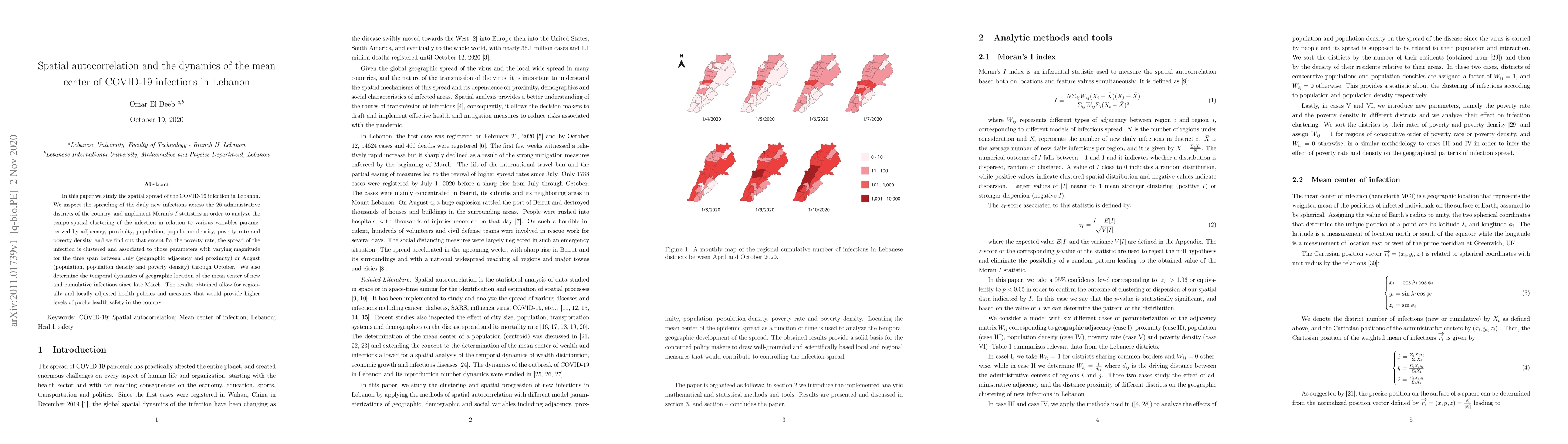
In this paper we study the spatial spread of the COVID-19 infection in Lebanon. We inspect the spreading of the daily new infections across the 26 administrative districts of the country, and implement Moran's $I$ statistics in order to analyze the tempo-spatial clustering of the infection in relation to various variables parameterized by adjacency, proximity, population, population density, poverty rate and poverty density, and we find out that except for the poverty rate, the spread of the infection is clustered and associated to those parameters with varying magnitude for the time span between July (geographic adjacency and proximity) or August (population, population density and poverty density) through October. We also determine the temporal dynamics of geographic location of the mean center of new and cumulative infections since late March. The results obtained allow for regionally and locally adjusted health policies and measures that would provide higher levels of public health safety in the country.
AI Key Findings
Get AI-generated insights about this paper's methodology, results, and significance.
Paper Details
PDF Preview
Key Terms
Citation Network
Current paper (gray), citations (green), references (blue)
Display is limited for performance on very large graphs.
Similar Papers
Found 4 papersDynamics of COVID-19 models with asymptomatic infections and quarantine measures
Songbai Guo, Zuohuan Zheng, Yuling Xue et al.
Prevalence of influenza A and B and respiratory syncytial virus infections before and during COVID-19 pandemic in the pediatric population in Lebanon: A retrospective study.
Salameh, Pascale, Eid, Reem, Sayad, Alain et al.
| Title | Authors | Year | Actions |
|---|
Comments (0)