Summary

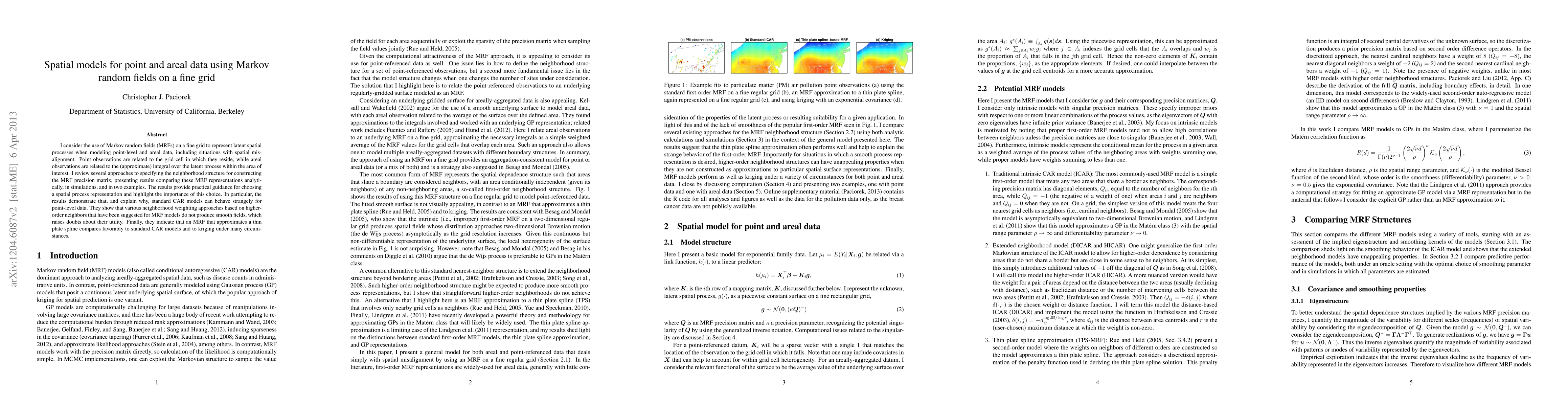
I consider the use of Markov random fields (MRFs) on a fine grid to represent latent spatial processes when modeling point-level and areal data, including situations with spatial misalignment. Point observations are related to the grid cell in which they reside, while areal observations are related to the (approximate) integral over the latent process within the area of interest. I review several approaches to specifying the neighborhood structure for constructing the MRF precision matrix, presenting results comparing these MRF representations analytically, in simulations, and in two examples. The results provide practical guidance for choosing a spatial process representation and highlight the importance of this choice. In particular, the results demonstrate that, and explain why, standard CAR models can behave strangely for point-level data. They show that various neighborhood weighting approaches based on higher-order neighbors that have been suggested for MRF models do not produce smooth fields, which raises doubts about their utility. Finally, they indicate that an MRF that approximates a thin plate spline compares favorably to standard CAR models and to kriging under many circumstances.

AI Key Findings

Get AI-generated insights about this paper's methodology, results, and significance.

Paper Details

PDF Preview

Download PDF

Key Terms

latent (0.214)
analytically (0.114)
data (0.096)
various (0.078)
consider (0.077)
structure (0.071)
use (0.067)
order (0.066)

Citation Network

Current paper (gray), citations (green), references (blue)

Current Paper
Citations
References
Click to view
Title Authors Year Actions
A dimension reduction approach to edge weight estimation for use in spatial models
Michael F. Christensen, Jo Eidsvik
2024
View Paper
Safer neighborhoods? Violent crime and trauma volume pre/post targeted police interventions in Dallas, Texas.
Jacob W. Roden-Foreman, Morgan Adkins, Philip M Edmundson, Catherine Glenn, Brian Tibbs
2023
View Paper
A spatio‐temporal Dirichlet process mixture model for coronavirus disease‐19
Jaewoo Park, Seorim Yi, Won Chang, J. Mateu
2022
View Paper
Interpolation of Precipitation Extremes on a Large Domain Toward IDF Curve Construction at Unmonitored Locations
J. Jalbert, C. Genest, L. Perreault
2022
View Paper
Pivotal discrepancy measures for Bayesian modelling of spatio-temporal data
Lindsay R. Morris, Nokuthaba Sibanda
2022
View Paper
A statistical interpolation code for ocean analysis and forecasting
A. Srinivasan, T. Chin, E. Chassignet, M. Iskandarani
2021
View Paper
Gaussian process regression‐based detection and correction of disturbances in surface topography measurements
G. Maculotti, Gianfranco Genta, D. Quagliotti, M. Galetto, H. N. Hansen
2021
View Paper
Spatial Weighted Analysis of Malnutrition Among Children in Nigeria: A Bayesian Approach
O. Egbon, Omodolapo Somo-Aina, E. Gayawan
2021
View Paper
Spatial Weighted Analysis of Malnutrition Among Children in Nigeria: A Bayesian Approach
O. Egbon, Omodolapo Somo-Aina, E. Gayawan
2021
View Paper
Predicting extreme surges from sparse data using a copula‐based hierarchical Bayesian spatial model
N. Beck, C. Genest, J. Jalbert, M. Mailhot
2019
View Paper
Joint quantile regression for spatial data
Xu Chen, S. Tokdar
2019
View Paper
Spatial autoregressive models for statistical inference from ecological data
J. Hoef, E. Peterson, M. Hooten, E. Hanks, Marie-Josèe Fortin
2018
View Paper
A spatiotemporal model for extreme precipitation simulated by a climate model, with an application to assessing changes in return levels over North America
J. Jalbert, A. Favre, Claude J. P. Bélisle, J. Angers
2017
View Paper
Making the most of spatial information in health: a tutorial in Bayesian disease mapping for areal data.
Su Yun Kang, S. Cramb, Nicole M White, Stephen J. Ball, K. Mengersen
2016
View Paper
Modeling Spatio-Temporal Extreme Events Using Graphical Models
Hang Yu, J. Dauwels
2016
View Paper
Patterns of livestock activity on heterogeneous subalpine pastures reveal distinct responses to spatial autocorrelation, environment and management
Hermel Homburger, A. Lüscher, M. Scherer‐Lorenzen, M. Schneider
2015
View Paper
Statistically-Estimated Tree Composition for the Northeastern United States at Euro-American Settlement
C. Paciorek, S. Goring, A. Thurman, C. Cogbill, John W. Williams, D. Mladenoff, Jody A. Peters, Jun Zhu, J. McLachlan
2015
View Paper
The choice of spatial scales and spatial smoothness priors for various spatial patterns.
Su Yun Kang, J. McGree, K. Mengersen
2014
View Paper
Simulation-free Bayesian Analysis for Temporally Misaligned Data with Application to Ice Cores
T. Doan, A. Parnell, J. Haslett
2014
View Paper
Spatial and Temporal Modelling of Hoki Distribution using Gaussian Markov Random Fields
L. Morris
2017
View Paper
Computationally efficient specifications of spatial point process models and spatio-temporal Gaussian models: Combining remote sensing drivers with geospatial disease case data to enhance geographic epidemiology
B. Ziniti
2016
View Paper
Bayesian inference for misaligned irregular time series with application to palaeoclimate reconstruction
T. Doan
2015
View Paper
Beyond Gaussian : copula graphical models for non-Gaussian data
Hang Yu
2015
View Paper

Comments (0)

This website uses cookies to ensure you get the best experience. Learn more