Publication
Metrics
AI Quick Summary
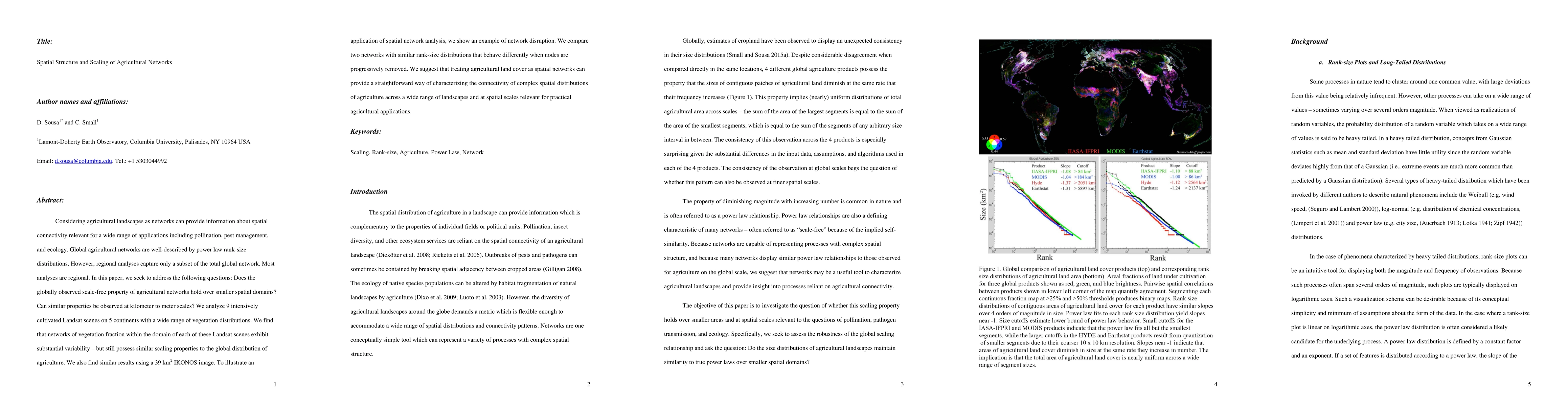
This paper investigates whether the globally observed scale-free property of agricultural networks persists at smaller spatial scales, analyzing intensively cultivated Landsat scenes and an IKONOS image. It finds that while there is variability, the networks still exhibit similar scaling properties, suggesting that spatial network analysis can effectively characterize agricultural connectivity.
Paper Preview
Abstract
Considering agricultural landscapes as networks can provide information about spatial connectivity relevant for a wide range of applications including pollination, pest management, and ecology. Global agricultural networks are well-described by power law rank-size distributions. However, regional analyses capture only a subset of the total global network. Most analyses are regional. In this paper, we seek to address the following questions: Does the globally observed scale-free property of agricultural networks hold over smaller spatial domains? Can similar properties be observed at kilometer to meter scales? We analyze 9 intensively cultivated Landsat scenes on 5 continents with a wide range of vegetation distributions. We find that networks of vegetation fraction within the domain of each of these Landsat scenes exhibit substantial variability - but still possess similar scaling properties to the global distribution of agriculture. We also find similar results using a 39 km2 IKONOS image. To illustrate an application of spatial network analysis, we show an example of network disruption. We compare two networks with similar rank-size distributions that behave differently when nodes are progressively removed. We suggest that treating agricultural land cover as spatial networks can provide a straightforward way of characterizing the connectivity of complex spatial distributions of agriculture across a wide range of landscapes and at spatial scales relevant for practical agricultural applications.
AI Key Findings
Get AI-generated insights about this paper's methodology, results, significance, and more — seven facets brought into focus.
Impact
Paper Details
PDF Preview
Key Terms
Citation Network
Current paper (gray), citations (green), references (blue)
Display is limited for performance on very large graphs.
Discussion 0