ArxivLens

Publication

Published: Oct 08, 2025
Categories: cs.LG

Metrics

Source: ArXiv

Quick Answers

What methodology did the authors use?

The research employs multimodal Earth observation data and uncertainty quantification methods to analyze spatial uncertainty in wildfire spread forecasting. It uses deep ensembles, Bayesian neural networks, and calibration metrics like ECE, Brier Score, and NLL to assess predictive uncertainty. More in Methodology →

What are the key results?

Predictive uncertainty shows coherent spatial patterns concentrated near fire perimeters — High-uncertainty regions form consistent 20-60 meter buffer zones around predicted firelines More in Key Results →

Why is this work significant?

This work enables more robust wildfire management systems by integrating structured uncertainty maps into decision-making processes, supporting climate adaptation and disaster response under increasing fire risks. More in Significance →

What are the main limitations?

Focus on epistemic (not aleatoric) uncertainty — Limited to U.S.-only coverage More in Limitations →

Paper Preview

Abstract

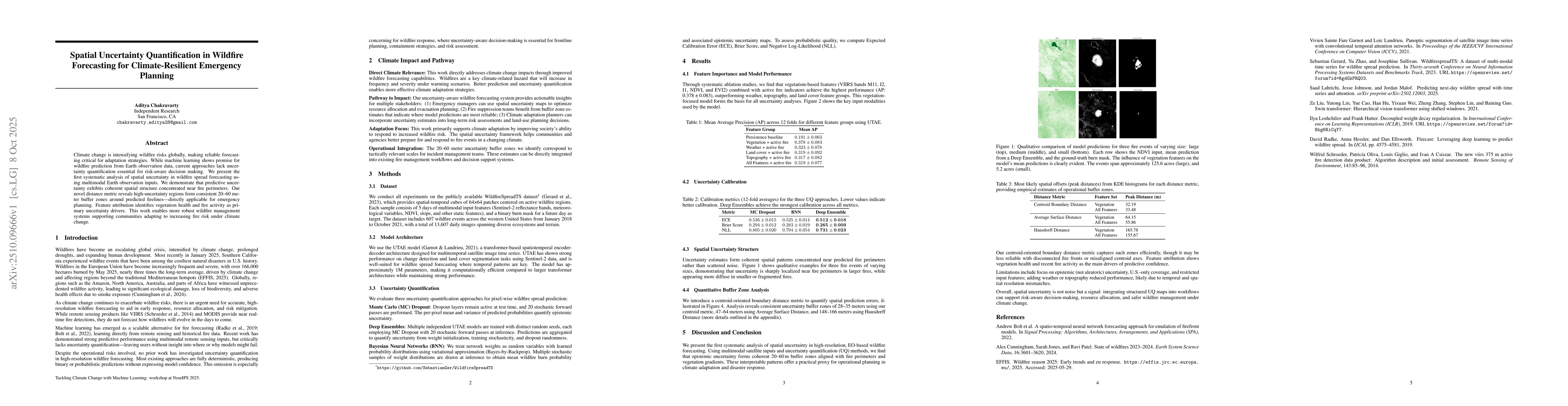
Climate change is intensifying wildfire risks globally, making reliable forecasting critical for adaptation strategies. While machine learning shows promise for wildfire prediction from Earth observation data, current approaches lack uncertainty quantification essential for risk-aware decision making. We present the first systematic analysis of spatial uncertainty in wildfire spread forecasting using multimodal Earth observation inputs. We demonstrate that predictive uncertainty exhibits coherent spatial structure concentrated near fire perimeters. Our novel distance metric reveals high-uncertainty regions form consistent 20-60 meter buffer zones around predicted firelines - directly applicable for emergency planning. Feature attribution identifies vegetation health and fire activity as primary uncertainty drivers. This work enables more robust wildfire management systems supporting communities adapting to increasing fire risk under climate change.

Key Findings, in focus

Seven facets of this paper, analysed and brought into focus by AI.

AI-generated · verify against source Generated Nov 01, 2025
In focus · one-line synthesis

This work enables more robust wildfire management systems by integrating structured uncertainty maps into decision-making processes, supporting climate adaptation and disaster response under increasing fire risks.

01
MethodologyHow they did it

The research employs multimodal Earth observation data and uncertainty quantification methods to analyze spatial uncertainty in wildfire spread forecasting. It uses deep ensembles, Bayesian neural networks, and calibration metrics like ECE, Brier Score, and NLL to assess predictive uncertainty.

02
ResultsWhat they found
  • Predictive uncertainty shows coherent spatial patterns concentrated near fire perimeters
  • High-uncertainty regions form consistent 20-60 meter buffer zones around predicted firelines
  • Vegetation health and recent fire activity are primary drivers of predictive uncertainty
03
SignificanceWhy it matters

This work enables more robust wildfire management systems by integrating structured uncertainty maps into decision-making processes, supporting climate adaptation and disaster response under increasing fire risks.

04
Technical ContributionsWhat's new technically

Development of a centroid-oriented boundary distance metric to quantify spatial prediction errors and integration of uncertainty quantification into high-resolution wildfire forecasting models.

05
NoveltyWhat sets it apart

First systematic analysis of spatial uncertainty in EO-based wildfire forecasting, combining multimodal satellite inputs with uncertainty quantification to provide interpretable, actionable insights for emergency planning.

06
LimitationsWhat to be cautious about
  • Focus on epistemic (not aleatoric) uncertainty
  • Limited to U.S.-only coverage
  • Restricted input features with potential resolution mismatches
07
Future WorkWhere it goes next
  • Incorporating weather and topography with improved temporal/spatial resolution
  • Expanding coverage to global datasets
  • Enhancing uncertainty quantification for disconnected fire fronts

Paper Details

Paper ID: 2510.09666
Categories:
cs.LG

How to Cite This Paper

Reference manager: RIS EndNote


Discussion 0

This website uses cookies to ensure you get the best experience. Learn more