Paper Preview
Abstract
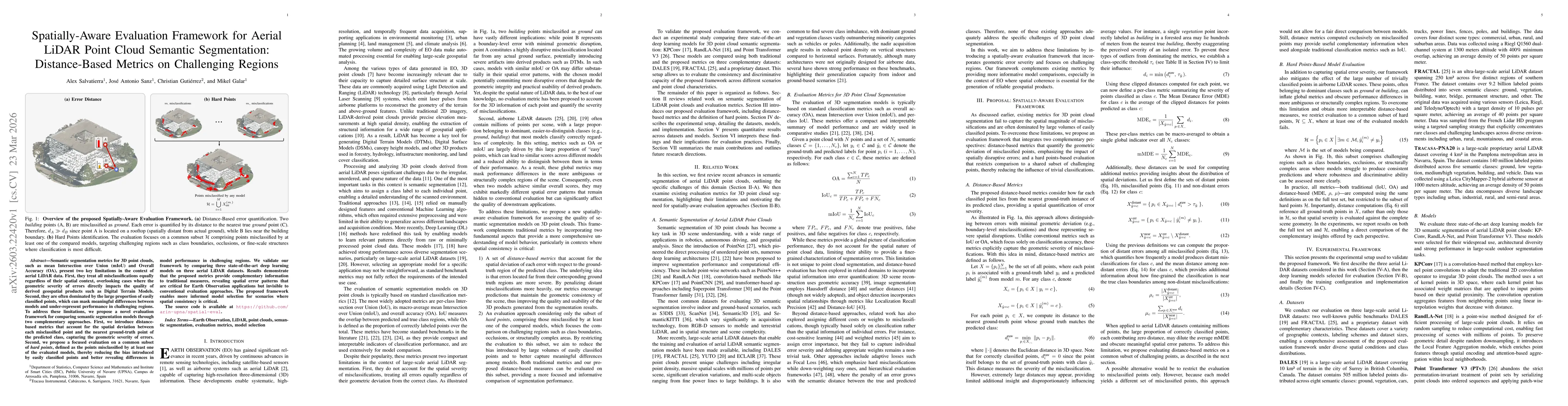
Semantic segmentation metrics for 3D point clouds, such as mean Intersection over Union (mIoU) and Overall Accuracy (OA), present two key limitations in the context of aerial LiDAR data. First, they treat all misclassifications equally regardless of their spatial context, overlooking cases where the geometric severity of errors directly impacts the quality of derived geospatial products such as Digital Terrain Models. Second, they are often dominated by the large proportion of easily classified points, which can mask meaningful differences between models and under-represent performance in challenging regions. To address these limitations, we propose a novel evaluation framework for comparing semantic segmentation models through two complementary approaches. First, we introduce distance-based metrics that account for the spatial deviation between each misclassified point and the nearest ground-truth point of the predicted class, capturing the geometric severity of errors. Second, we propose a focused evaluation on a common subset of hard points, defined as the points misclassified by at least one of the evaluated models, thereby reducing the bias introduced by easily classified points and better revealing differences in model performance in challenging regions. We validate our framework by comparing three state-of-the-art deep learning models on three aerial LiDAR datasets. Results demonstrate that the proposed metrics provide complementary information to traditional measures, revealing spatial error patterns that are critical for Earth Observation applications but invisible to conventional evaluation approaches. The proposed framework enables more informed model selection for scenarios where spatial consistency is critical.
AI Key Findings
Get AI-generated insights about this paper's methodology, results, and significance.
Paper Details
How to Cite This Paper
@article{salvatierra2026spatially,
  title         = {Spatially-Aware Evaluation Framework for Aerial LiDAR Point Cloud Semantic Segmentation: Distance-Based Metrics on Challenging Regions},
  author        = {Salvatierra, Alex and Gutiérrez, Christian and Sanz, José Antonio and others},
  year          = {2026},
  eprint        = {2603.22420},
  archivePrefix = {arXiv},
  primaryClass  = {cs.CV},
}Salvatierra, A., Gutiérrez, C., Sanz, J., & Galar, M. (2026). Spatially-Aware Evaluation Framework for Aerial LiDAR Point Cloud Semantic Segmentation: Distance-Based Metrics on Challenging Regions. arXiv. https://arxiv.org/abs/2603.22420Salvatierra, Alex, et al. "Spatially-Aware Evaluation Framework for Aerial LiDAR Point Cloud Semantic Segmentation: Distance-Based Metrics on Challenging Regions." arXiv, 2026, arxiv.org/abs/2603.22420.PDF Preview
Similar Papers
Found 4 papersCurbNet: Curb Detection Framework Based on LiDAR Point Cloud Segmentation
Guoyang Zhao, Fulong Ma, Weiqing Qi et al.
TransUPR: A Transformer-based Uncertain Point Refiner for LiDAR Point Cloud Semantic Segmentation
Zifan Yu, Meida Chen, Zhikang Zhang et al.
Comments (0)