Quick Summary:

This dataset provides detailed meteorological and ancillary data for rainfall streamflow modeling across five river basins in central Europe, enabling more accurate hydrological modeling.

Summary

We present a dataset for rainfall streamflow modeling that is fully spatially resolved with the aim of taking neural network-driven hydrological modeling beyond lumped catchments. To this end, we compiled data covering five river basins in central Europe: upper Danube, Elbe, Oder, Rhine, and Weser. The dataset contains meteorological forcings, as well as ancillary information on soil, rock, land cover, and orography. The data is harmonized to a regular 9km times 9km grid and contains daily values that span from October 1981 to September 2011. We also provide code to further combine our dataset with publicly available river discharge data for end-to-end rainfall streamflow modeling.

AI Key Findings

Generated Jun 08, 2025

Methodology

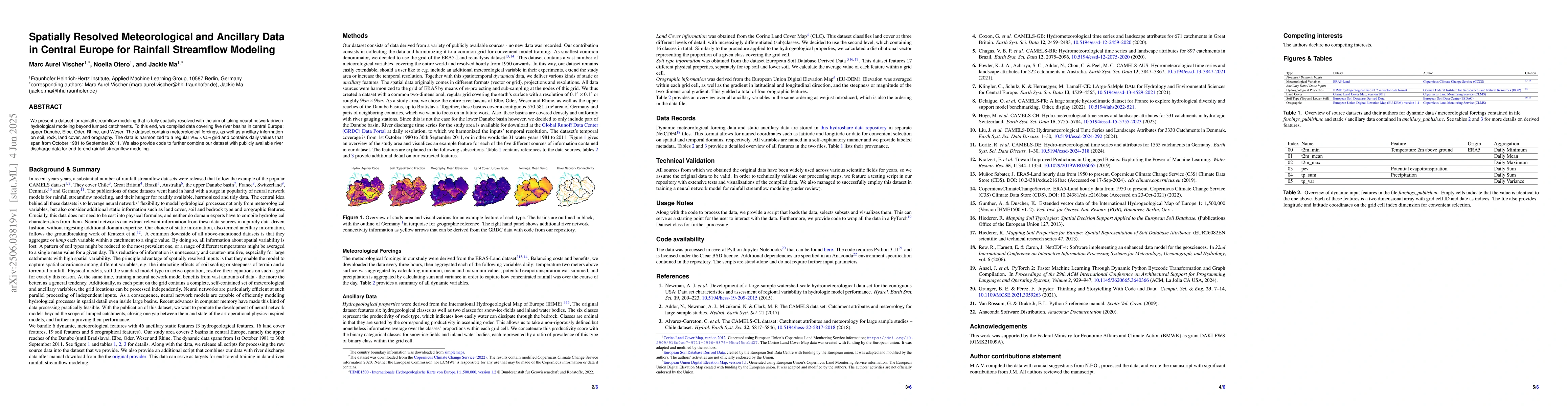
The research compiled a dataset covering five river basins in central Europe, including meteorological forcings and ancillary information on soil, rock, land cover, and orography. The data is harmonized to a regular 9km x 9km grid with daily values from October 1981 to September 2011.

Key Results

  • A spatially resolved dataset for rainfall streamflow modeling was created.
  • The dataset covers five river basins: upper Danube, Elbe, Oder, Rhine, and Weser.

Significance

This dataset aims to advance neural network-driven hydrological modeling beyond lumped catchments, enabling more accurate rainfall streamflow modeling in central Europe.

Technical Contribution

The harmonization of diverse meteorological and ancillary data into a regular grid for hydrological modeling.

Novelty

This work provides a comprehensive, spatially resolved dataset specifically designed for neural network-driven hydrological modeling, going beyond traditional lumped catchment approaches.

Limitations

  • The dataset only covers central Europe and the specified river basins.
  • The time span from 1981 to 2011 may not capture recent climate change impacts.

Future Work

  • Integration with publicly available river discharge data for end-to-end modeling.
  • Expanding the dataset to include more diverse climate scenarios and basins.

Paper Details

PDF Preview

Download PDF

Key Terms

No key terms available for this paper.

Citation Network

Current paper (gray), citations (green), references (blue)

Current Paper
Citations
References
Click to view
Title Authors Year Actions
Spatially Resolved Rainfall Streamflow Modeling in Central Europe
Marc Aurel Vischer, Noelia Otero, Jackie Ma
View Paper

Comments (0)

This website uses cookies to ensure you get the best experience. Learn more