ArxivLens
ArXiv cs.CV

Spatially-Weighted CLIP for Street-View Geo-localization

Chunsong Chen, Fengjiao Li, Haoling Huang, Meiliu Wu, Ting Han, Yiping Chen

2604.04357 Published Apr 6, 2026
View PDF

Publication

Published: Apr 06, 2026
Categories: cs.CV

Metrics

Source: ArXiv

Quick Answers

What methodology did the authors use?

SW-CLIP replaces hard one‑hot negatives in CLIP with distance‑decayed soft labels derived from geodesic distances, encodes geographic positions as learnable text tokens, and adds neighborhood‑consistency and regional‑fairness regularizers to enforce spatial autocorrelation during contrastive training. More in Methodology →

What are the key results?

Median geo‑localization error dropped from 276.8 m to 91.96 m and mean error from 723.5 m to 449.25 m on an eight‑city UK dataset. — Recall@1 and other retrieval metrics improved dramatically, showing that SW‑CLIP consistently ranks the correct location higher. More in Key Results →

Why is this work significant?

The work demonstrates that embedding spatial autocorrelation into vision‑language contrastive learning yields substantial gains in street‑view geo‑localization, offering a general recipe for integrating geographic principles into multimodal models and improving real‑world location‑based services. More in Significance →

What are the main limitations?

Evaluation is confined to eight UK cities, limiting evidence of cross‑regional generalization. — The method assumes accurate GPS coordinates; noisy or missing location data could undermine performance. More in Limitations →

Paper Preview

Abstract

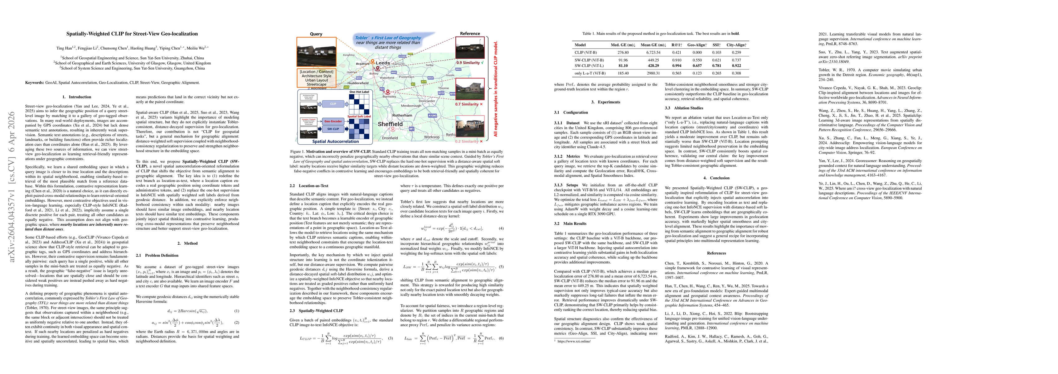
This paper proposes Spatially-Weighted CLIP (SW-CLIP), a novel framework for street-view geo-localization that explicitly incorporates spatial autocorrelation into vision-language contrastive learning. Unlike conventional CLIP-based methods that treat all non-matching samples as equally negative, SW-CLIP leverages Tobler's First Law of Geography to model geographic relationships through distance-aware soft supervision. Specifically, we introduce a location-as-text representation to encode geographic positions and replace one-hot InfoNCE targets with spatially weighted soft labels derived from geodesic distance. Additionally, a neighborhood-consistency regularization is employed to preserve local spatial structure in the embedding space. Experiments on a multi-city dataset demonstrate that SW-CLIP significantly improves geo-localization accuracy, reduces long-tail errors, and enhances spatial coherence compared to standard CLIP. The results highlight the importance of shifting from semantic alignment to geographic alignment for robust geo-localization and provide a general paradigm for integrating spatial principles into multimodal representation learning.

Key Findings, in focus

Seven facets of this paper, analysed and brought into focus by AI.

AI-generated · verify against source Generated Apr 07, 2026
In focus · one-line synthesis

The work demonstrates that embedding spatial autocorrelation into vision‑language contrastive learning yields substantial gains in street‑view geo‑localization, offering a general recipe for integrating geographic principles into multimodal models and improving real‑world location‑based services.

01
MethodologyHow they did it

SW-CLIP replaces hard one‑hot negatives in CLIP with distance‑decayed soft labels derived from geodesic distances, encodes geographic positions as learnable text tokens, and adds neighborhood‑consistency and regional‑fairness regularizers to enforce spatial autocorrelation during contrastive training.

02
ResultsWhat they found
  • Median geo‑localization error dropped from 276.8 m to 91.96 m and mean error from 723.5 m to 449.25 m on an eight‑city UK dataset.
  • Recall@1 and other retrieval metrics improved dramatically, showing that SW‑CLIP consistently ranks the correct location higher.
  • Spatial smoothness and city‑alignment scores increased, indicating a more geographically coherent embedding space.
03
SignificanceWhy it matters

The work demonstrates that embedding spatial autocorrelation into vision‑language contrastive learning yields substantial gains in street‑view geo‑localization, offering a general recipe for integrating geographic principles into multimodal models and improving real‑world location‑based services.

04
Technical ContributionsWhat's new technically

A spatially weighted contrastive learning framework that encodes geographic positions as text, replaces hard negatives with distance‑aware soft labels, and enforces neighborhood consistency and regional fairness, enabling geographic alignment in CLIP.

05
NoveltyWhat sets it apart

First to encode geographic coordinates as learnable text tokens and to apply Tobler’s First Law via distance‑decayed soft supervision in a CLIP‑style contrastive objective, shifting the focus from semantic to geographic alignment.

06
LimitationsWhat to be cautious about
  • Evaluation is confined to eight UK cities, limiting evidence of cross‑regional generalization.
  • The method assumes accurate GPS coordinates; noisy or missing location data could undermine performance.
07
Future WorkWhere it goes next
  • Apply SW‑CLIP to larger, global datasets and incorporate additional modalities such as map imagery or textual descriptions.
  • Explore adaptive weighting or hierarchical spatial models to further reduce long‑tail errors and enhance robustness.

Paper Details

Paper ID: 2604.04357
Categories:
cs.CV

How to Cite This Paper

Reference manager: RIS EndNote


Discussion 0

This website uses cookies to ensure you get the best experience. Learn more