This paper proposes a spatio-temporal-spectral-angular observation model integrating UAV and mobile mapping vehicle data for comprehensive urban mapping, addressing data voids and occlusions through multi-source data fusion. Experiments in Baisha Town, China, demonstrate the model's effectiveness in achieving accurate, rapid, and complete urban scene data collection.
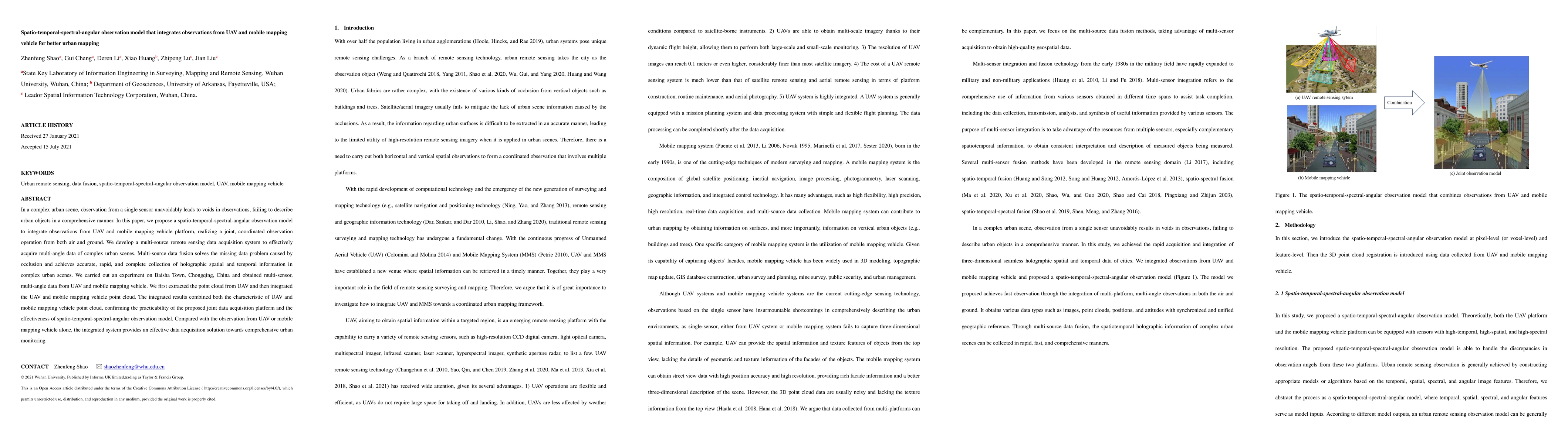
In a complex urban scene, observation from a single sensor unavoidably leads to voids in observations, failing to describe urban objects in a comprehensive manner. In this paper, we propose a spatio-temporal-spectral-angular observation model to integrate observations from UAV and mobile mapping vehicle platform, realizing a joint, coordinated observation operation from both air and ground. We develop a multi-source remote sensing data acquisition system to effectively acquire multi-angle data of complex urban scenes. Multi-source data fusion solves the missing data problem caused by occlusion and achieves accurate, rapid, and complete collection of holographic spatial and temporal information in complex urban scenes. We carried out an experiment on Baisha Town, Chongqing, China and obtained multi-sensor, multi-angle data from UAV and mobile mapping vehicle. We first extracted the point cloud from UAV and then integrated the UAV and mobile mapping vehicle point cloud. The integrated results combined both the characteristic of UAV and mobile mapping vehicle point cloud, confirming the practicability of the proposed joint data acquisition platform and the effectiveness of spatio-temporal-spectral-angular observation model. Compared with the observation from UAV or mobile mapping vehicle alone, the integrated system provides an effective data acquisition solution towards comprehensive urban monitoring.
This graph shows how this paper is connected to other research. The current paper is shown in dark gray, papers that cite it are in green, and papers it references are in blue. You can:
• Hover over any node to see the paper title
• Click a node to view that paper's details
• Drag nodes to rearrange the graph
• Use the zoom controls (bottom right) to zoom in/out
Title | Authors | Year | Actions |
---|---|---|---|
Long-term spatiotemporal features of aerosol optical characteristics and relative humidity in China’s offshore areas
|
Jie He, Zhao Li, Linyu He, Jian Wang, Weiping Jiang
|
2025
|
View Paper |
CSSDet: small object detection via cross-scale feature enhancement on drone-view images
|
Gui Cheng, Qing Ding, Bowen Cai, Chaoya Dang, Yu Wang, Xiaolong Zuo, Zhenfeng Shao
|
2024
|
View Paper |
Low-Cost LiDAR-GNSS-UAV Technology Development for PT Garam’s Three-Dimensional Stockpile Modelling Needs
|
D. Imani, M. N. Cahyadi, Imam Wahyu Farid, Ronny Mardianto
|
2023
|
View Paper |
Multiquadrotor Formation Tracking With Mixed Constraints: A Hierarchical Rolling Optimization Approach
|
Si-Sheng Liu, Teng‐Fei Ding, Ming‐Feng Ge, Xiao-Gang Dong, Zhiwei Liu
|
2023
|
View Paper |
Improved instance segmentation for slender urban road facility extraction using oblique aerial images
|
Zhu Mao, Xianfeng Huang, Wenyuan Niu, Xuan Wang, Zepeng Hou, Fan Zhang
|
2023
|
View Paper |
Emerging Issues in Mapping Urban Impervious Surfaces Using High-Resolution Remote Sensing Images
|
Z. Shao, T. Cheng, Hu Fu, D. Li, Xiao Huang
|
2023
|
View Paper |
Modeling carbon storage in urban vegetation: Progress, challenges, and opportunities
|
Q. Zhuang, Z. Shao, J. Gong, D. Li, Xiao Huang, Ya Zhang, Xiaodi Xu, Chaoya Dang, Jinlong Chen, O. Altan, Shixin Wu
|
2022
|
View Paper |
INDOOR AND OUTDOOR STRUCTURED MONOMER RECONSTRUCTION OF CITY 3D REAL SCENE BASED ON NONLINEAR OPTIMIZATION AND INTEGRATION OF MULTI-SOURCE AND MULTI-MODAL DATA
|
Z. Shao, G. Cheng, Y. Yi
|
2022
|
View Paper |
Simultaneous Localization and Mapping (SLAM) and Data Fusion in Unmanned Aerial Vehicles: Recent Advances and Challenges
|
Abhishek Gupta, Xavier N Fernando
|
2022
|
View Paper |
Comparison of Layer-stacking and Dempster-Shafer Theory-based Methods Using Sentinel-1 and Sentinel-2 Data Fusion in Urban Land Cover Mapping
|
Dang Hung Bui, L. Mucsi
|
2022
|
View Paper |
Mapping impervious surfaces with a hierarchical spectral mixture analysis incorporating endmember spatial distribution
|
Z. Shao, Yuan Zhang, Cheng Zhang, Xiao Huang, T. Cheng
|
2022
|
View Paper |
Phenology-based delineation of irrigated and rain-fed paddy fields with Sentinel-2 imagery in Google Earth Engine
|
D. G. D. Torre, Jay Gao, C. Macinnis‐Ng, Yan Shi
|
2021
|
View Paper |
Land cover classification from remote sensing images based on multi-scale fully convolutional network
|
Rui Li, Shunyi Zheng, Chenxi Duan
|
2020
|
View Paper |
A Morphological Feature-Oriented Algorithm for Extracting Impervious Surface Areas Obscured by Vegetation in Collaboration with OSM Road Networks in Urban Areas
|
Taomin Mao, Yewen Fan, Shuang Zhi, Jinshan Tang
|
2022
|
View Paper |
Yuan Yuan, Depeng Jin, Yong Li, Jingtao Ding, Chonghua Han
Published: 2024-11-19
Hong Yang, Yiming Pan, Yuan Zhu, Yanqiang Wang, Yadong An
Published: 2024-02-27
Rui Xu, Ting Gan, Yonghong Liu, Xinru Yang, Yuzhuang Pian, Dawen Yao, Ruhui Cao, Yixin Fu
Published: 2025-03-16
Comments (0)