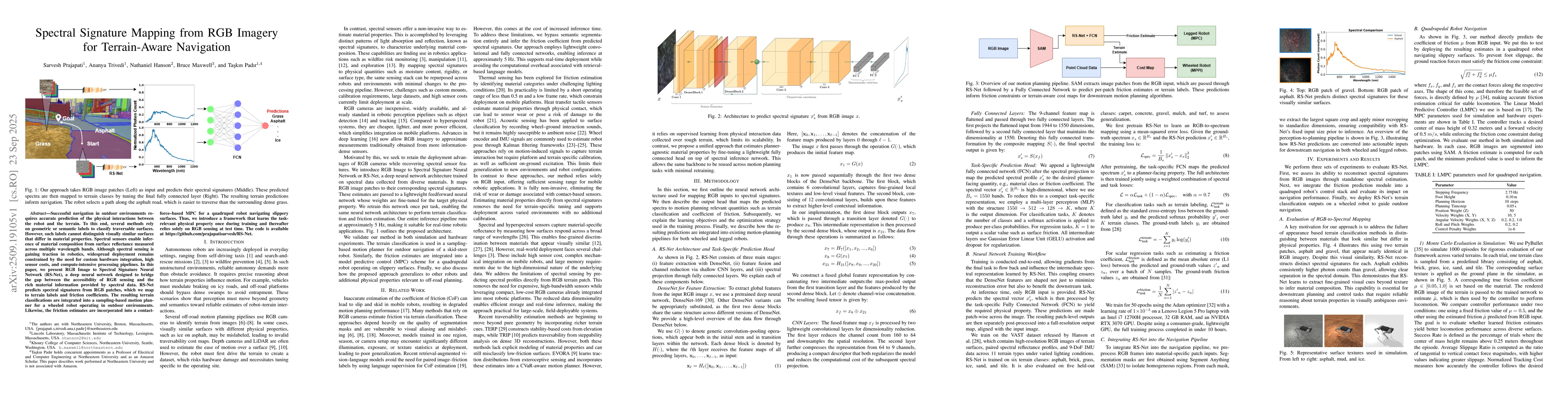
Successful navigation in outdoor environments requires accurate prediction of
the physical interactions between the robot and the terrain. To this end,
several methods rely on geometric or semantic labels to classify traversable
surfaces. However, such labels cannot distinguish visually similar surfaces
that differ in material properties. Spectral sensors enable inference of
material composition from surface reflectance measured across multiple
wavelength bands. Although spectral sensing is gaining traction in robotics,
widespread deployment remains constrained by the need for custom hardware
integration, high sensor costs, and compute-intensive processing pipelines. In
this paper, we present RGB Image to Spectral Signature Neural Network (RS-Net),
a deep neural network designed to bridge the gap between the accessibility of
RGB sensing and the rich material information provided by spectral data. RS-Net
predicts spectral signatures from RGB patches, which we map to terrain labels
and friction coefficients. The resulting terrain classifications are integrated
into a sampling-based motion planner for a wheeled robot operating in outdoor
environments. Likewise, the friction estimates are incorporated into a
contact-force-based MPC for a quadruped robot navigating slippery surfaces.
Thus, we introduce a framework that learns the task-relevant physical property
once during training and thereafter relies solely on RGB sensing at test time.
The code is available at https://github.com/prajapatisarvesh/RS-Net.
Discussion 0