Query-Conditioned Gaussian Splatting (QCGS) fuses sparse automatic weather station (AWS) observations with satellite imagery using a radar point proposal network and an implicit neural representation to predict Gaussian parameters for each queried point, selectively rendering only precipitation regions.
Station2Radar: query conditioned gaussian splatting for precipitation field
Publication
Metrics
Quick Answers
What methodology did the authors use?
Query-Conditioned Gaussian Splatting (QCGS) fuses sparse automatic weather station (AWS) observations with satellite imagery using a radar point proposal network and an implicit neural representation to predict Gaussian parameters for each queried point, selectively rendering only precipitation regions. More in Methodology →
What are the key results?
Over 50% reduction in RMSE compared to conventional gridded products — Consistently higher CSI across multiple thresholds and spatial scales, outperforming satellite-only products More in Key Results →
Why is this work significant?
Provides high-quality, resolution-flexible precipitation fields that bridge radar and gauge data, improving regional precipitation accuracy and offering valuable training data for data-driven forecasting models, thereby enhancing both traditional NWP systems and emerging AI-based weather prediction. More in Significance →
What are the main limitations?
Relies on sparse AWS data, limiting applicability in regions with few gauge stations — Lacks temporal coherence across consecutive frames, causing inconsistencies in dynamic precipitation patterns More in Limitations →
Abstract
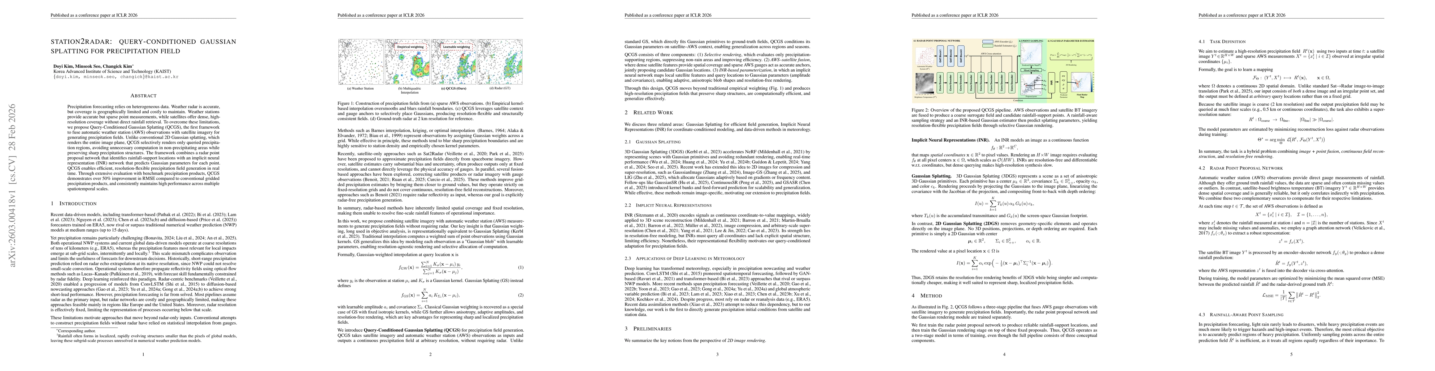
Precipitation forecasting relies on heterogeneous data. Weather radar is accurate, but coverage is geographically limited and costly to maintain. Weather stations provide accurate but sparse point measurements, while satellites offer dense, high-resolution coverage without direct rainfall retrieval. To overcome these limitations, we propose Query-Conditioned Gaussian Splatting (QCGS), the first framework to fuse automatic weather station (AWS) observations with satellite imagery for generating precipitation fields. Unlike conventional 2D Gaussian splatting, which renders the entire image plane, QCGS selectively renders only queried precipitation regions, avoiding unnecessary computation in non-precipitating areas while preserving sharp precipitation structures. The framework combines a radar point proposal network that identifies rainfall-support locations with an implicit neural representation (INR) network that predicts Gaussian parameters for each point. QCGS enables efficient, resolution-flexible precipitation field generation in real time. Through extensive evaluation with benchmark precipitation products, QCGS demonstrates over 50\% improvement in RMSE compared to conventional gridded precipitation products, and consistently maintains high performance across multiple spatiotemporal scales.
Key Findings, in focus
Seven facets of this paper, analysed and brought into focus by AI.
Provides high-quality, resolution-flexible precipitation fields that bridge radar and gauge data, improving regional precipitation accuracy and offering valuable training data for data-driven forecasting models, thereby enhancing both traditional NWP systems and emerging AI-based weather prediction.
- Over 50% reduction in RMSE compared to conventional gridded products
- Consistently higher CSI across multiple thresholds and spatial scales, outperforming satellite-only products
- QCGS fields exhibit lower bias and RMSE relative to radar-derived products, aligning more closely with AWS gauge observations
Provides high-quality, resolution-flexible precipitation fields that bridge radar and gauge data, improving regional precipitation accuracy and offering valuable training data for data-driven forecasting models, thereby enhancing both traditional NWP systems and emerging AI-based weather prediction.
Introduces query-conditioned Gaussian splatting combined with implicit neural representation for selective, resolution-free rendering of precipitation fields, enabling efficient and accurate fusion of point-based gauge data with satellite imagery.
First framework to fuse AWS and satellite data via Gaussian splatting conditioned on queries, selectively rendering only precipitation regions and integrating INR for parameter prediction, surpassing existing satellite-only precipitation products.
- Relies on sparse AWS data, limiting applicability in regions with few gauge stations
- Lacks temporal coherence across consecutive frames, causing inconsistencies in dynamic precipitation patterns
- Incorporate temporal conditioning to enforce coherence across consecutive frames
- Retrain downstream forecasting models directly on QCGS-generated inputs to close the performance gap with radar-based models
Discussion 0