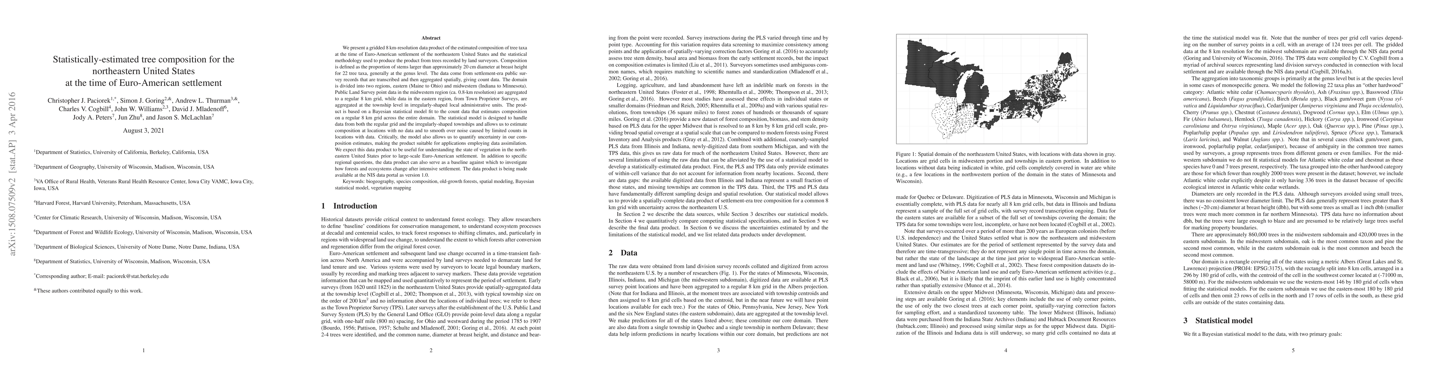
Summary
We present a gridded 8 km-resolution data product of the estimated composition of tree taxa at the time of Euro-American settlement of the northeastern United States and the statistical methodology used to produce the product from trees recorded by land surveyors. Composition is defined as the proportion of stems larger than approximately 20 cm diameter at breast height for 22 tree taxa, generally at the genus level. The data come from settlement-era public survey records that are transcribed and then aggregated spatially, giving count data. The domain is divided into two regions, eastern (Maine to Ohio) and midwestern (Indiana to Minnesota). Public Land Survey point data in the midwestern region (ca. 0.8-km resolution) are aggregated to a regular 8 km grid, while data in the eastern region, from Town Proprietor Surveys, are aggregated at the township level in irregularly-shaped local administrative units. The product is based on a Bayesian statistical model fit to the count data that estimates composition on a regular 8 km grid across the entire domain. The statistical model is designed to handle data from both the regular grid and the irregularly-shaped townships and allows us to estimate composition at locations with no data and to smooth over noise caused by limited counts in locations with data. The model also allows us to quantify uncertainty in our composition estimates, making the product suitable for applications employing data assimilation. We expect this data product to be useful for understanding the state of vegetation in the northeastern United States prior to large-scale Euro-American settlement. In addition to specific regional questions, the data product can also serve as a baseline against which to investigate how forests and ecosystems change after intensive settlement. The data product is available at the NIS data portal as version 1.0.
AI Key Findings
Get AI-generated insights about this paper's methodology, results, and significance.
Paper Details
PDF Preview
Key Terms
Citation Network
Current paper (gray), citations (green), references (blue)
Display is limited for performance on very large graphs.
Similar Papers
Found 4 papersUnmasking Obstructive Sleep Apnea: Estimated Prevalence and Impact in the United States.
Yee, John, Azarbarzin, Ali, Sönmez, Ibrahim et al.
An Automated Machine Learning Approach for Detecting Anomalous Peak Patterns in Time Series Data from a Research Watershed in the Northeastern United States Critical Zone
Byung Suk Lee, Ijaz Ul Haq, Donna M. Rizzo et al.
| Title | Authors | Year | Actions |
|---|
Comments (0)