Quick Summary:

A new method using deep learning improves elevation measurements from airborne SAR images with more accuracy and wider range than conventional methods.

Summary

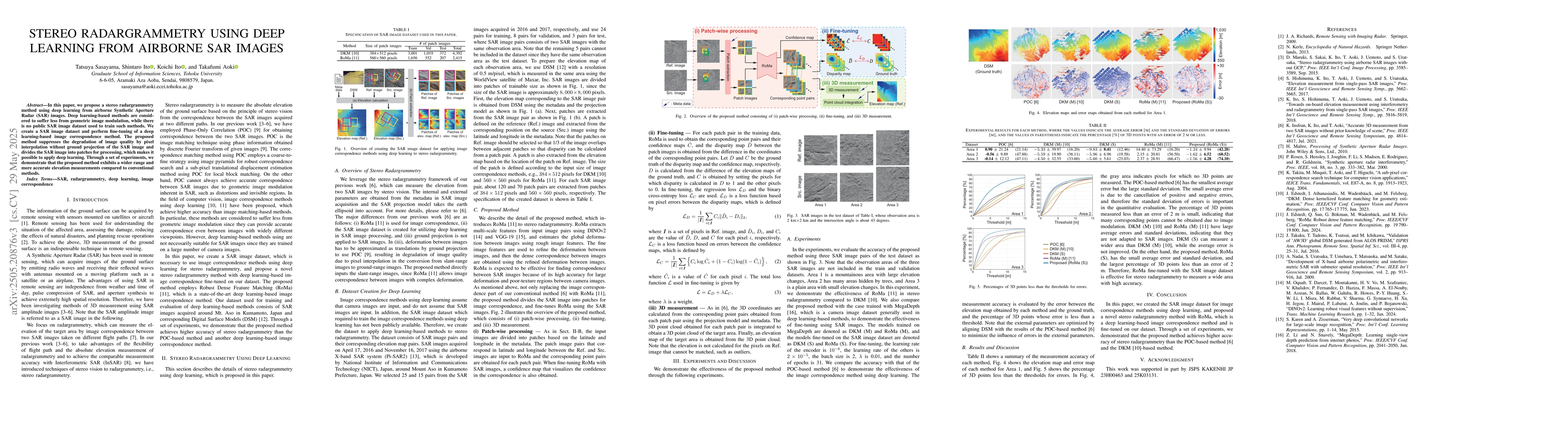
In this paper, we propose a stereo radargrammetry method using deep learning from airborne Synthetic Aperture Radar (SAR) images. Deep learning-based methods are considered to suffer less from geometric image modulation, while there is no public SAR image dataset used to train such methods. We create a SAR image dataset and perform fine-tuning of a deep learning-based image correspondence method. The proposed method suppresses the degradation of image quality by pixel interpolation without ground projection of the SAR image and divides the SAR image into patches for processing, which makes it possible to apply deep learning. Through a set of experiments, we demonstrate that the proposed method exhibits a wider range and more accurate elevation measurements compared to conventional methods. The project web page is available at: https://gsisaoki.github.io/IGARSS2025_sasayama/

AI Key Findings

Generated Jun 07, 2025

Methodology

The research proposes a stereo radargrammetry method using deep learning from airborne SAR images, creating a SAR image dataset for fine-tuning a deep learning-based image correspondence method, and processing SAR images in patches to apply deep learning without pixel interpolation or ground projection.

Key Results

  • The proposed method suppresses image quality degradation by pixel interpolation.
  • The method divides SAR images into patches for processing, enabling deep learning application.
  • Experiments demonstrate wider range and more accurate elevation measurements compared to conventional methods.

Significance

This research is important as it addresses the lack of deep learning methods for SAR images due to geometric image modulation, and presents a dataset and method for improved elevation measurements in various applications like topographic mapping, disaster assessment, and environmental monitoring.

Technical Contribution

The main technical contribution is the creation of a SAR image dataset and the development of a fine-tuned deep learning-based image correspondence method for stereo radargrammetry, which improves elevation measurement accuracy.

Novelty

This work stands out by addressing the scarcity of deep learning methods for SAR images, proposing a solution through dataset creation and patch-based processing, resulting in enhanced elevation measurement performance.

Limitations

  • The paper does not discuss limitations explicitly, but potential limitations could include the reliance on a specific dataset and the generalization of the method to diverse terrains or SAR image qualities.
  • Performance in real-world scenarios with varying atmospheric conditions and noise levels is not explicitly addressed.

Future Work

  • Exploration of more extensive and diverse SAR image datasets for further validation and generalization.
  • Investigation of method adaptability to different SAR image resolutions and acquisition geometries.

Paper Details

PDF Preview

Download PDF

Key Terms

No key terms available for this paper.

Citation Network

Current paper (gray), citations (green), references (blue)

Current Paper
Citations
References
Click to view

No citations found for this paper.

Comments (0)

This website uses cookies to ensure you get the best experience. Learn more