Authors
Summary
Streetscapes are an essential component of urban space. Their assessment is presently either limited to morphometric properties of their mass skeleton or requires labor-intensive qualitative evaluations of visually perceived qualities. This paper introduces SAGAI: Streetscape Analysis with Generative Artificial Intelligence, a modular workflow for scoring street-level urban scenes using open-access data and vision-language models. SAGAI integrates OpenStreetMap geometries, Google Street View imagery, and a lightweight version of the LLaVA model to generate structured spatial indicators from images via customizable natural language prompts. The pipeline includes an automated mapping module that aggregates visual scores at both the point and street levels, enabling direct cartographic interpretation. It operates without task-specific training or proprietary software dependencies, supporting scalable and interpretable analysis of urban environments. Two exploratory case studies in Nice and Vienna illustrate SAGAI's capacity to produce geospatial outputs from vision-language inference. The initial results show strong performance for binary urban-rural scene classification, moderate precision in commercial feature detection, and lower estimates, but still informative, of sidewalk width. Fully deployable by any user, SAGAI can be easily adapted to a wide range of urban research themes, such as walkability, safety, or urban design, through prompt modification alone.
AI Key Findings
Generated Jun 09, 2025
Methodology
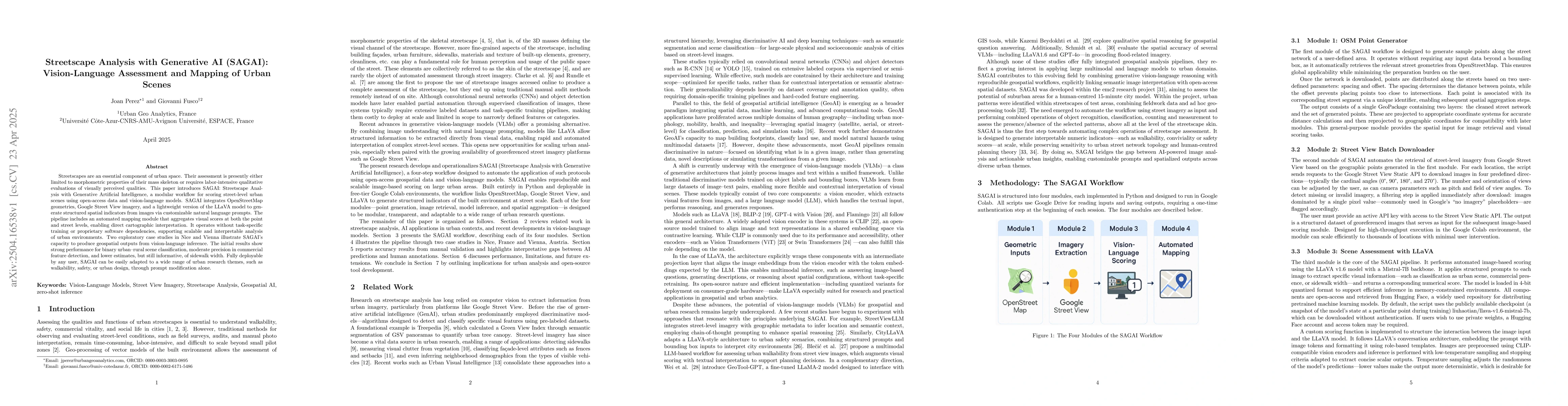
SAGAI is a modular workflow that uses open-access data and the LLaVA model to score street-level urban scenes. It integrates OpenStreetMap geometries, Google Street View imagery, and a lightweight version of the LLaVA model to generate structured spatial indicators via customizable natural language prompts.
Key Results
- SAGAI achieved high accuracy (over 90%) in scene classification (urban vs. rural).
- Moderate precision was observed in commercial feature detection (storefront counting).
- Lower but still informative estimates were made for sidewalk width measurement.
- The system demonstrated strong performance for binary urban-rural scene classification.
- Initial results showed moderate performance in detecting commercial features and sidewalk widths.
Significance
SAGAI enriches streetscape analysis by incorporating micro-scale elements typically assessed visually, absent from geodatabases. It offers a reproducible, extensible workflow for researchers and practitioners, suitable for various urban applications like walkability audits, infrastructure planning, and spatial equity assessments.
Technical Contribution
SAGAI presents a lightweight, reproducible workflow that automates the scoring of street-level urban environments using open-access data and generative vision-language models, demonstrating zero-shot generalization capability across different cities or scoring schemes.
Novelty
SAGAI stands out by leveraging on-line street imagery through generative AI algorithms to enrich streetscape analysis with micro-scale elements, absent from available geodatabases, and offering a modular architecture suitable for various urban applications.
Limitations
- The model struggles with contextual reasoning in complex urban scenes, as evidenced by misclassifications in hybrid landscapes.
- Sidewalk width estimations rarely exceed 1 meter, even in visibly wider areas, due to a broad range of error types.
- Interpretation of results for sidewalk width measurement is limited by overall uncertainty and variability.
Future Work
- Explore the integration of few-shot learning modules to allow user-provided labeled datasets for local model calibration.
- Investigate the use of heavier AI models, prompt engineering, and higher-precision quantization formats to improve accuracy and robustness.
- Evaluate commercial multimodal systems to compare their performance with LLaVA in the context of SAGAI.
Paper Details
PDF Preview
Citation Network
Current paper (gray), citations (green), references (blue)
Display is limited for performance on very large graphs.
Similar Papers
Found 4 papersUrbanSense:AFramework for Quantitative Analysis of Urban Streetscapes leveraging Vision Large Language Models
Shuai Lu, Ran Luo, Miao Zhang et al.
HGS-Mapping: Online Dense Mapping Using Hybrid Gaussian Representation in Urban Scenes
Jieru Zhao, Wenchao Ding, Zijun Xu et al.
Thermal Comfort in Sight: Thermal Affordance and its Visual Assessment for Sustainable Streetscape Design
Filip Biljecki, Pengyuan Liu, Adrian Chong et al.
No citations found for this paper.
Comments (0)