STRMs: Spatial Temporal Reasoning Models for Vision-Based Localization Rivaling GPS Precision

Source: ArXiv

AI Quick Summary

This paper introduces VAE-RNN and VAE-Transformer models for vision-based localization, achieving GPS-level precision without satellite image databases. The VAE-Transformer model outperforms existing methods, rivaling commercial GPS accuracy while using significantly less computational resources.

Share: Share on X LinkedIn

Summary

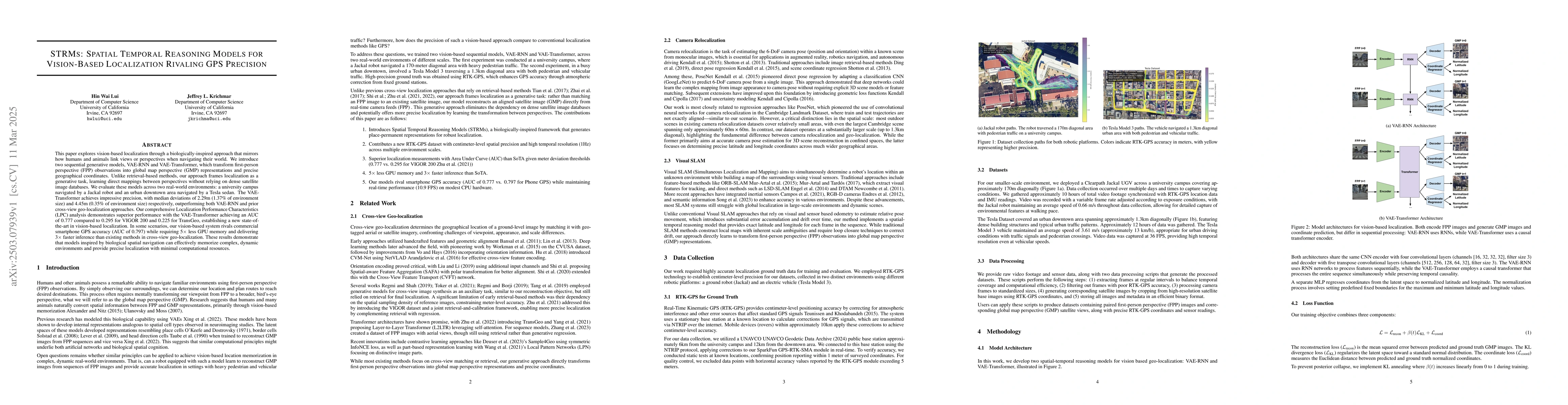
This paper explores vision-based localization through a biologically-inspired approach that mirrors how humans and animals link views or perspectives when navigating their world. We introduce two sequential generative models, VAE-RNN and VAE-Transformer, which transform first-person perspective (FPP) observations into global map perspective (GMP) representations and precise geographical coordinates. Unlike retrieval-based methods, our approach frames localization as a generative task, learning direct mappings between perspectives without relying on dense satellite image databases. We evaluate these models across two real-world environments: a university campus navigated by a Jackal robot and an urban downtown area navigated by a Tesla sedan. The VAE-Transformer achieves impressive precision, with median deviations of 2.29m (1.37% of environment size) and 4.45m (0.35% of environment size) respectively, outperforming both VAE-RNN and prior cross-view geo-localization approaches. Our comprehensive Localization Performance Characteristics (LPC) analysis demonstrates superior performance with the VAE-Transformer achieving an AUC of 0.777 compared to 0.295 for VIGOR 200 and 0.225 for TransGeo, establishing a new state-of-the-art in vision-based localization. In some scenarios, our vision-based system rivals commercial smartphone GPS accuracy (AUC of 0.797) while requiring 5x less GPU memory and delivering 3x faster inference than existing methods in cross-view geo-localization. These results demonstrate that models inspired by biological spatial navigation can effectively memorize complex, dynamic environments and provide precise localization with minimal computational resources.

AI Key Findings

Generated Jun 10, 2025

Methodology

The research introduces two sequential generative models, VAE-RNN and VAE-Transformer, which transform first-person perspective (FPP) observations into global map perspective (GMP) representations and precise geographical coordinates, learning direct mappings between perspectives without relying on dense satellite image databases.

Key Results

  • VAE-Transformer achieves median deviations of 2.29m (1.37% of environment size) in a university campus and 4.45m (0.35% of environment size) in an urban downtown area, outperforming VAE-RNN and prior approaches.
  • The VAE-Transformer model establishes a new state-of-the-art in vision-based localization with an AUC of 0.777, surpassing VIGOR 200 (0.295) and TransGeo (0.225).
  • In certain scenarios, the vision-based system rivals commercial smartphone GPS accuracy (AUC of 0.797) while using 5x less GPU memory and delivering 3x faster inference.

Significance

This research demonstrates that models inspired by biological spatial navigation can effectively memorize complex, dynamic environments and provide precise localization with minimal computational resources, potentially revolutionizing vision-based localization systems.

Technical Contribution

The development of VAE-RNN and VAE-Transformer models for vision-based localization, framing the task as a generative problem rather than a retrieval one.

Novelty

Unlike retrieval-based methods, these models learn direct mappings between perspectives, avoiding reliance on extensive satellite image databases, and achieve superior performance in terms of precision and computational efficiency.

Limitations

  • The study was conducted in limited real-world environments: a university campus and an urban downtown area.
  • Performance in diverse and extreme environmental conditions (e.g., heavy weather, low-light, or highly cluttered scenes) is not addressed.

Future Work

  • Extending the approach to more varied environments and conditions to validate its robustness.
  • Investigating the integration of additional sensor data (e.g., LiDAR, IMU) to further enhance localization accuracy.

Paper Details

PDF Preview

Download PDF

Citation Network

Current paper (gray), citations (green), references (blue)

Display is limited for performance on very large graphs.

Current Paper
Citations
References
Click to view

No citations found for this paper.

Comments (0)

This website uses cookies to ensure you get the best experience. Learn more