Sub-metre Lunar DEM Generation and Validation from Chandrayaan-2 OHRC Multi-View Imagery Using Open-Source Photogrammetry
Publication
Metrics
Paper Preview
Abstract
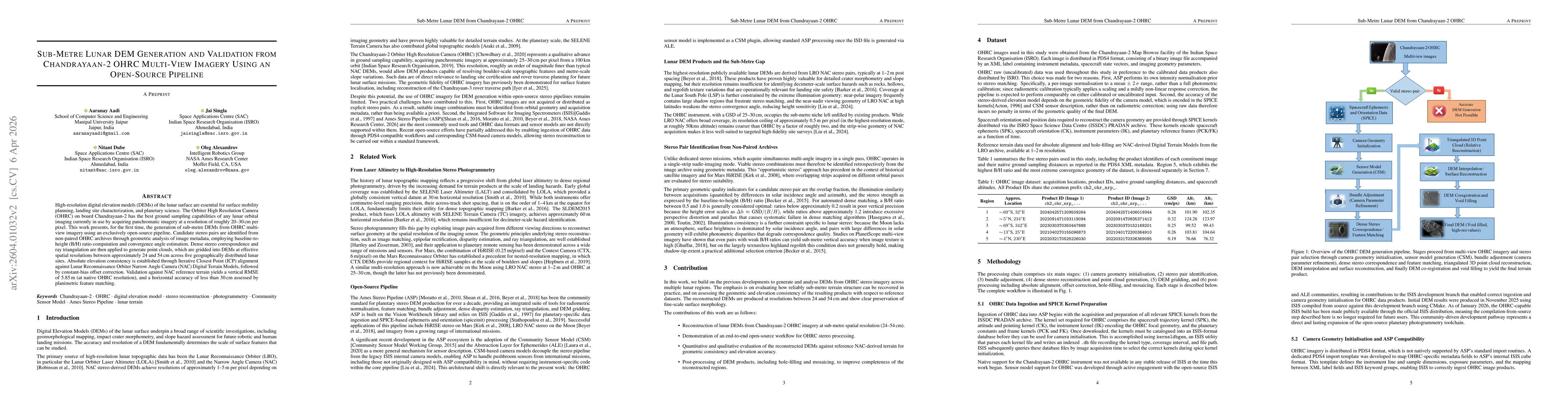
High-resolution digital elevation models (DEMs) of the lunar surface are essential for surface mobility planning, landing site characterization, and planetary science. The Orbiter High Resolution Camera (OHRC) on board Chandrayaan-2 has the best ground sampling capabilities of any lunar orbital imaging currently in use by acquiring panchromatic imagery at a resolution of roughly 20-30 cm per pixel. This work presents, for the first time, the generation of sub-metre DEMs from OHRC multi-view imagery using an exclusively open-source pipeline. Candidate stereo pairs are identified from non-paired OHRC archives through geometric analysis of image metadata, employing baseline-to-height (B/H) ratio computation and convergence angle estimation. Dense stereo correspondence and ray triangulation are then applied to generate point clouds, which are gridded into DEMs at effective spatial resolutions between approximately 24 and 54 cm across five geographically distributed lunar sites. Absolute elevation consistency is established through Iterative Closest Point (ICP) alignment against Lunar Reconnaissance Orbiter Narrow Angle Camera (NAC) Digital Terrain Models, followed by constant-bias offset correction. Validation against NAC reference terrain yields a vertical RMSE of 5.85 m (at native OHRC resolution), and a horizontal accuracy of less than 30 cm assessed by planimetric feature matching.
AI Key Findings
Get AI-generated insights about this paper's methodology, results, significance, and more — seven facets brought into focus.
Discussion 0