SuperRivolution: Fine-Scale Rivers from Coarse Temporal Satellite Imagery
Publication
Metrics
Paper Preview
Abstract
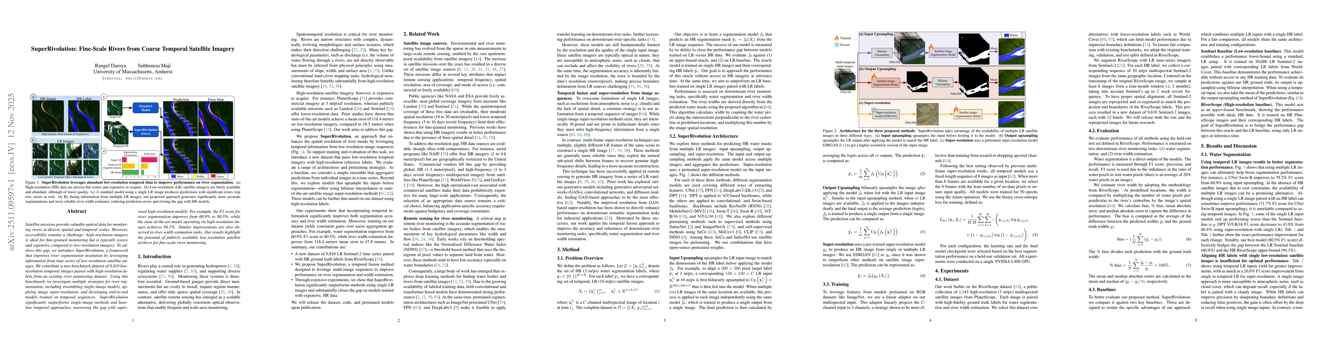
Satellite missions provide valuable optical data for monitoring rivers at diverse spatial and temporal scales. However, accessibility remains a challenge: high-resolution imagery is ideal for fine-grained monitoring but is typically scarce and expensive compared to low-resolution imagery. To address this gap, we introduce SuperRivolution, a framework that improves river segmentation resolution by leveraging information from time series of low-resolution satellite images. We contribute a new benchmark dataset of 9,810 low-resolution temporal images paired with high-resolution labels from an existing river monitoring dataset. Using this benchmark, we investigate multiple strategies for river segmentation, including ensembling single-image models, applying image super-resolution, and developing end-to-end models trained on temporal sequences. SuperRivolution significantly outperforms single-image methods and baseline temporal approaches, narrowing the gap with supervised high-resolution models. For example, the F1 score for river segmentation improves from 60.9% to 80.5%, while the state-of-the-art model operating on high-resolution images achieves 94.1%. Similar improvements are also observed in river width estimation tasks. Our results highlight the potential of publicly available low-resolution satellite archives for fine-scale river monitoring.
AI Key Findings
Get AI-generated insights about this paper's methodology, results, significance, and more — seven facets brought into focus.
Discussion 0