System Calibration of a Field Phenotyping Robot with Multiple High-Precision Profile Laser Scanners
Publication
Metrics
AI Quick Summary
This paper presents a novel calibration method for a field phenotyping robot equipped with high-precision laser scanners, achieving a 0.8 cm root-mean-square error in distance to a georeferenced point cloud. The method optimizes scanner-to-robot transformations and employs a factor graph-based pose estimation fusing various measurement sources for precise calibration.
Paper Preview
Abstract
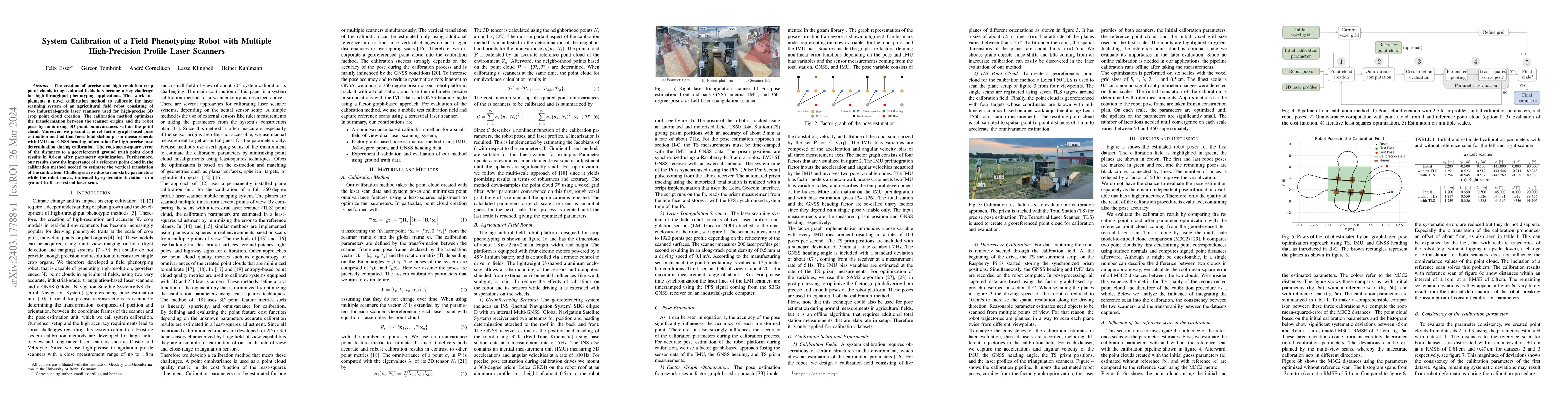
The creation of precise and high-resolution crop point clouds in agricultural fields has become a key challenge for high-throughput phenotyping applications. This work implements a novel calibration method to calibrate the laser scanning system of an agricultural field robot consisting of two industrial-grade laser scanners used for high-precise 3D crop point cloud creation. The calibration method optimizes the transformation between the scanner origins and the robot pose by minimizing 3D point omnivariances within the point cloud. Moreover, we present a novel factor graph-based pose estimation method that fuses total station prism measurements with IMU and GNSS heading information for high-precise pose determination during calibration. The root-mean-square error of the distances to a georeferenced ground truth point cloud results in 0.8 cm after parameter optimization. Furthermore, our results show the importance of a reference point cloud in the calibration method needed to estimate the vertical translation of the calibration. Challenges arise due to non-static parameters while the robot moves, indicated by systematic deviations to a ground truth terrestrial laser scan.
AI Key Findings
Get AI-generated insights about this paper's methodology, results, significance, and more — seven facets brought into focus.
Impact
Paper Details
Authors
PDF Preview
Key Terms
Citation Network
Current paper (gray), citations (green), references (blue)
Display is limited for performance on very large graphs.
Discussion 0