TDFANet: Encoding Sequential 4D Radar Point Clouds Using Trajectory-Guided Deformable Feature Aggregation for Place Recognition

Source: ArXiv

AI Quick Summary

TDFANet proposes a novel method for place recognition using sequential 4D radar point clouds, addressing the challenges of sparsity, noise, and low resolution. It employs trajectory-guided deformable feature aggregation to extract and combine spatio-temporal features, validated through real-world experiments demonstrating robustness in dynamic environments.

Share: Share on X LinkedIn

Summary

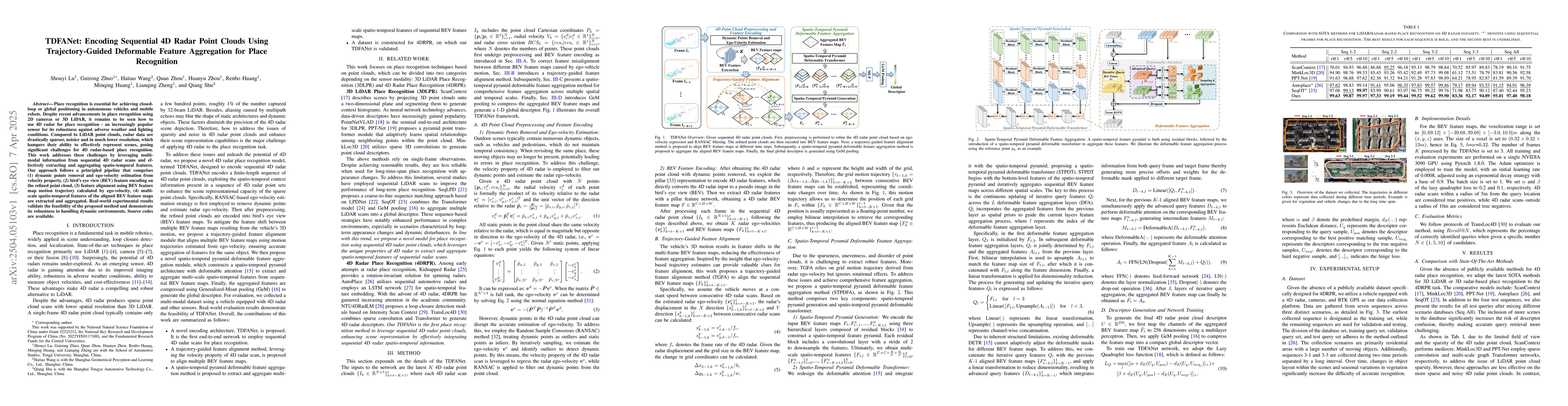
Place recognition is essential for achieving closed-loop or global positioning in autonomous vehicles and mobile robots. Despite recent advancements in place recognition using 2D cameras or 3D LiDAR, it remains to be seen how to use 4D radar for place recognition - an increasingly popular sensor for its robustness against adverse weather and lighting conditions. Compared to LiDAR point clouds, radar data are drastically sparser, noisier and in much lower resolution, which hampers their ability to effectively represent scenes, posing significant challenges for 4D radar-based place recognition. This work addresses these challenges by leveraging multi-modal information from sequential 4D radar scans and effectively extracting and aggregating spatio-temporal features.Our approach follows a principled pipeline that comprises (1) dynamic points removal and ego-velocity estimation from velocity property, (2) bird's eye view (BEV) feature encoding on the refined point cloud, (3) feature alignment using BEV feature map motion trajectory calculated by ego-velocity, (4) multi-scale spatio-temporal features of the aligned BEV feature maps are extracted and aggregated.Real-world experimental results validate the feasibility of the proposed method and demonstrate its robustness in handling dynamic environments. Source codes are available.

AI Key Findings

Generated Jun 10, 2025

Methodology

The methodology involves a pipeline with four main steps: (1) dynamic points removal and ego-velocity estimation from radar velocity property, (2) bird's eye view (BEV) feature encoding on the refined point cloud, (3) feature alignment using BEV feature map motion trajectory calculated by ego-velocity, and (4) extraction and aggregation of multi-scale spatio-temporal features of the aligned BEV feature maps.

Key Results

  • TDFanet successfully encodes sequential 4D radar point clouds for place recognition.
  • The approach demonstrates robustness in dynamic environments.

Significance

This research is significant as it addresses the challenge of using sparse, noisy 4D radar data for place recognition, which is crucial for autonomous vehicles and mobile robots operating under adverse weather and lighting conditions.

Technical Contribution

The main technical contribution is the trajectory-guided deformable feature aggregation approach for encoding sequential 4D radar point clouds.

Novelty

This work is novel in its application of multi-modal information from sequential 4D radar scans and the use of a trajectory-guided deformable feature aggregation method for place recognition, addressing the unique challenges posed by radar data sparsity and low resolution.

Limitations

  • The method's performance has not been evaluated in all possible real-world scenarios.
  • Computational complexity and efficiency for real-time applications are not explicitly discussed.

Future Work

  • Investigate the method's performance under extreme weather conditions.
  • Explore optimization techniques to enhance computational efficiency for real-time implementation.

Paper Details

PDF Preview

Download PDF

Citation Network

Current paper (gray), citations (green), references (blue)

Display is limited for performance on very large graphs.

Current Paper
Citations
References
Click to view

No citations found for this paper.

Comments (0)

This website uses cookies to ensure you get the best experience. Learn more