Summary
Cross-modal drone navigation remains a challenging task in robotics, requiring efficient retrieval of relevant images from large-scale databases based on natural language descriptions. The RoboSense 2025 Track 4 challenge addresses this challenge, focusing on robust, natural language-guided cross-view image retrieval across multiple platforms (drones, satellites, and ground cameras). Current baseline methods, while effective for initial retrieval, often struggle to achieve fine-grained semantic matching between text queries and visual content, especially in complex aerial scenes. To address this challenge, we propose a two-stage retrieval refinement method: Caption-Guided Retrieval System (CGRS) that enhances the baseline coarse ranking through intelligent reranking. Our method first leverages a baseline model to obtain an initial coarse ranking of the top 20 most relevant images for each query. We then use Vision-Language-Model (VLM) to generate detailed captions for these candidate images, capturing rich semantic descriptions of their visual content. These generated captions are then used in a multimodal similarity computation framework to perform fine-grained reranking of the original text query, effectively building a semantic bridge between the visual content and natural language descriptions. Our approach significantly improves upon the baseline, achieving a consistent 5\% improvement across all key metrics (Recall@1, Recall@5, and Recall@10). Our approach win TOP-2 in the challenge, demonstrating the practical value of our semantic refinement strategy in real-world robotic navigation scenarios.
AI Key Findings
Generated Oct 12, 2025
Methodology
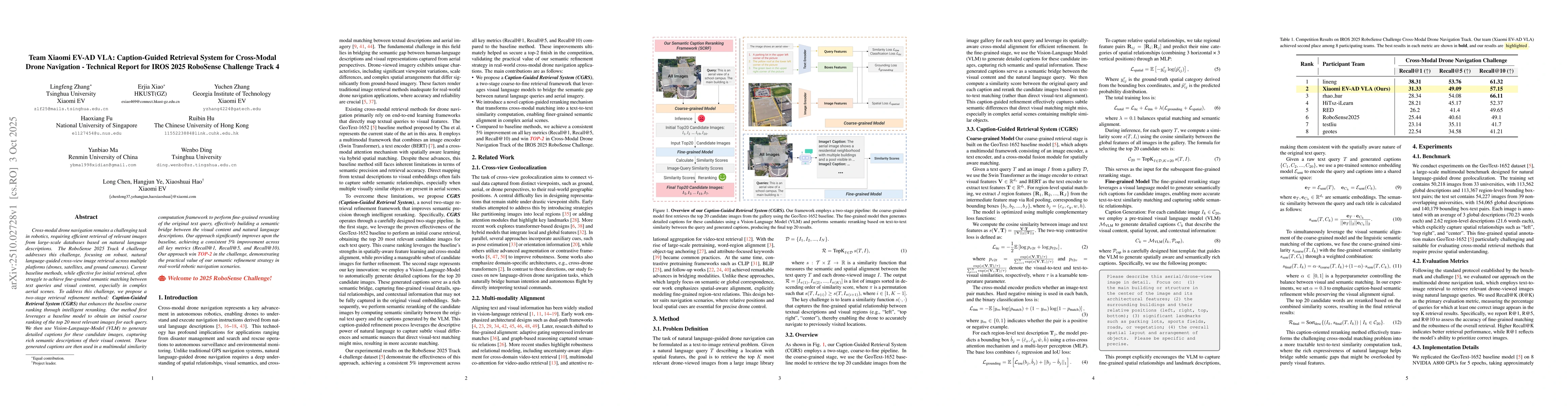
The research proposes a two-stage retrieval refinement method called Caption-Guided Retrieval System (CGRS). It first uses a baseline model (GeoText-1652) to retrieve top 20 candidate images, then employs a Vision-Language Model (VLM) to generate detailed captions for these images. These captions are used in a multimodal similarity computation framework to perform fine-grained reranking based on text-to-text similarity between the query and generated captions.
Key Results
- Achieved a consistent 5% improvement across all key metrics (Recall@1, Recall@5, and Recall@10) compared to the baseline
- Won TOP-2 in the IROS 2025 RoboSense Challenge Track 4, demonstrating the practical value of their semantic refinement strategy
- Generated captions that effectively captured fine-grained spatial relationships and landmark descriptions, improving semantic matching in complex aerial scenes
Significance
This research advances cross-modal drone navigation by bridging the semantic gap between natural language queries and visual content. The semantic refinement strategy has practical implications for real-world robotic navigation, enabling more accurate and reliable image retrieval for drone operations.
Technical Contribution
Proposed a novel two-stage retrieval system that combines spatially-aware cross-modal alignment with caption-guided semantic refinement, achieving more accurate text-to-image retrieval for drone navigation tasks.
Novelty
Emphasizes spatial-aware alignment and explicit modeling of fine-grained region-text relationships, which is different from previous approaches that focused primarily on global semantic correspondence. The method transforms cross-modal matching into a text-to-text similarity computation task through generated captions.
Limitations
- The approach relies on pre-trained vision-language models which may have biases or limitations in specific domain knowledge
- The caption generation process requires significant computational resources and offline time (12 hours) for processing
- The method's performance may degrade in scenarios with extremely complex or ambiguous spatial relationships
Future Work
- Exploring more efficient caption generation techniques with reduced computational overhead
- Investigating domain adaptation strategies to improve performance in new and unseen environments
- Enhancing spatial reasoning capabilities through integration with advanced 3D spatial models
- Developing more robust handling of ambiguous or noisy natural language queries
Paper Details
PDF Preview
Similar Papers
Found 5 papersTeam Xiaomi EV-AD VLA: Learning to Navigate Socially Through Proactive Risk Perception -- Technical Report for IROS 2025 RoboSense Challenge Social Navigation Track
Long Chen, Wenbo Ding, Xiaoshuai Hao et al.
Team Samsung-RAL: Technical Report for 2024 RoboDrive Challenge-Robust Map Segmentation Track
Jing Zhang, Yi Zhou, Xiaoshuai Hao et al.
A Parameter-Efficient Mixture-of-Experts Framework for Cross-Modal Geo-Localization
Tianle Zhang, Xuelong Li, Chi Zhang et al.
TrajTok: Technical Report for 2025 Waymo Open Sim Agents Challenge
Junchi Yan, Qifeng Li, Zhiyuan Zhang et al.
Comments (0)