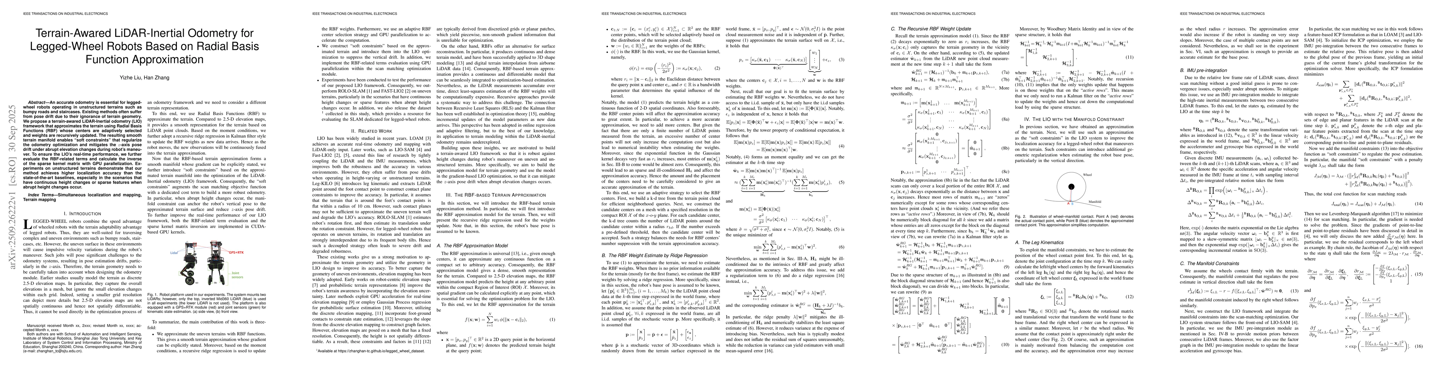
Quick Answers
What methodology did the authors use?
The research proposes RBF-LIO, a LiDAR-inertial odometry framework that integrates terrain constraints to enhance vertical localization accuracy. It uses radial basis functions (RBFs) to approximate terrain based on moment conditions, reformulating the problem as a recursive ridge regression task. The method introduces a terrain manifold as "soft constraints" into gradient-based LIO optimization to mitigate z-axis localization errors. More in Methodology →
What are the key results?
RBF-LIO significantly reduces both Absolute Trajectory Error (ATE) and Relative Trajectory Error (RTE) in scenarios with continuous height changes or sparse features, outperforming Fast-LIO2 and ROLO-SLAM. — The method maintains accurate vertical localization through continuous height corrections via "soft constraints", preserving global map consistency even during abrupt stair ascents. More in Key Results →
Why is this work significant?
This research addresses critical challenges in vertical localization for legged-wheel robots, improving navigation accuracy in complex terrains. The integration of terrain constraints with LiDAR-inertial systems offers new approaches for robust localization in environments with significant elevation changes. More in Significance →
What are the main limitations?
The current RBF formulation is limited to 2D height functions, making it unsuitable for multi-layered environments like overpasses or stacked floors. — The method relies on approximations of contact points, which may introduce errors in certain terrain configurations. More in Limitations →
Abstract
An accurate odometry is essential for legged-wheel robots operating in unstructured terrains such as bumpy roads and staircases. Existing methods often suffer from pose drift due to their ignorance of terrain geometry. We propose a terrain-awared LiDAR-Inertial odometry (LIO) framework that approximates the terrain using Radial Basis Functions (RBF) whose centers are adaptively selected and weights are recursively updated. The resulting smooth terrain manifold enables ``soft constraints" that regularize the odometry optimization and mitigates the $z$-axis pose drift under abrupt elevation changes during robot's maneuver. To ensure the LIO's real-time performance, we further evaluate the RBF-related terms and calculate the inverse of the sparse kernel matrix with GPU parallelization. Experiments on unstructured terrains demonstrate that our method achieves higher localization accuracy than the state-of-the-art baselines, especially in the scenarios that have continuous height changes or sparse features when abrupt height changes occur.
AI Key Findings
Generated Oct 01, 2025
Methodology — What approach did the authors take?
The research proposes RBF-LIO, a LiDAR-inertial odometry framework that integrates terrain constraints to enhance vertical localization accuracy. It uses radial basis functions (RBFs) to approximate terrain based on moment conditions, reformulating the problem as a recursive ridge regression task. The method introduces a terrain manifold as "soft constraints" into gradient-based LIO optimization to mitigate z-axis localization errors.
Key Results — What are the main findings?
- RBF-LIO significantly reduces both Absolute Trajectory Error (ATE) and Relative Trajectory Error (RTE) in scenarios with continuous height changes or sparse features, outperforming Fast-LIO2 and ROLO-SLAM.
- The method maintains accurate vertical localization through continuous height corrections via "soft constraints", preserving global map consistency even during abrupt stair ascents.
- RBF-LIO achieves comparable performance to Fast-LIO2 in rich-feature environments but demonstrates superior accuracy in challenging terrains with elevation changes.
Significance — Why does this research matter?
This research addresses critical challenges in vertical localization for legged-wheel robots, improving navigation accuracy in complex terrains. The integration of terrain constraints with LiDAR-inertial systems offers new approaches for robust localization in environments with significant elevation changes.
Technical Contribution — What is the technical contribution?
The paper introduces a novel approach to terrain modeling using RBFs with moment conditions, reformulating the problem as a recursive ridge regression task. It proposes a terrain manifold as "soft constraints" for gradient-based LIO optimization, enabling continuous vertical error correction.
Novelty — What is new about this work?
This work uniquely combines terrain constraint modeling with LiDAR-inertial odometry through RBF-based approximation, introducing "soft constraints" for vertical localization that improve accuracy without compromising system performance. The method's ability to maintain global map consistency during abrupt elevation changes represents a significant advancement over existing approaches.
Limitations — What are the limitations of this study?
- The current RBF formulation is limited to 2D height functions, making it unsuitable for multi-layered environments like overpasses or stacked floors.
- The method relies on approximations of contact points, which may introduce errors in certain terrain configurations.
Future Work — What did the authors propose for future work?
- Exploring more expressive surface representations to handle complex geometries in multi-layered environments.
- Integrating continuous approximation functions like RBF into reinforcement learning frameworks for legged-wheel robot locomotion.
- Enhancing the method's adaptability to dynamic and unstructured terrains through improved terrain modeling techniques.
How to Cite This Paper
@article{zhang2025terrain,
title = {Terrain-Awared LiDAR-Inertial Odometry for Legged-Wheel Robots Based on
Radial Basis Function Approximation},
author = {Zhang, Han and Liu, Yizhe},
year = {2025},
eprint = {2509.26222},
archivePrefix = {arXiv},
primaryClass = {cs.RO},
}
Zhang, H., & Liu, Y. (2025). Terrain-Awared LiDAR-Inertial Odometry for Legged-Wheel Robots Based on
Radial Basis Function Approximation. arXiv. https://arxiv.org/abs/2509.26222
Zhang, Han, and Yizhe Liu. "Terrain-Awared LiDAR-Inertial Odometry for Legged-Wheel Robots Based on
Radial Basis Function Approximation." arXiv, 2025, arxiv.org/abs/2509.26222.
PDF Preview
Similar Papers
Found 4 papersVILENS: Visual, Inertial, Lidar, and Leg Odometry for All-Terrain Legged Robots
David Wisth, Maurice Fallon, Marco Camurri
LIKO: LiDAR, Inertial, and Kinematic Odometry for Bipedal Robots
Qingrui Zhao, Mingyuan Li, Yongliang Shi et al.
Comments (0)