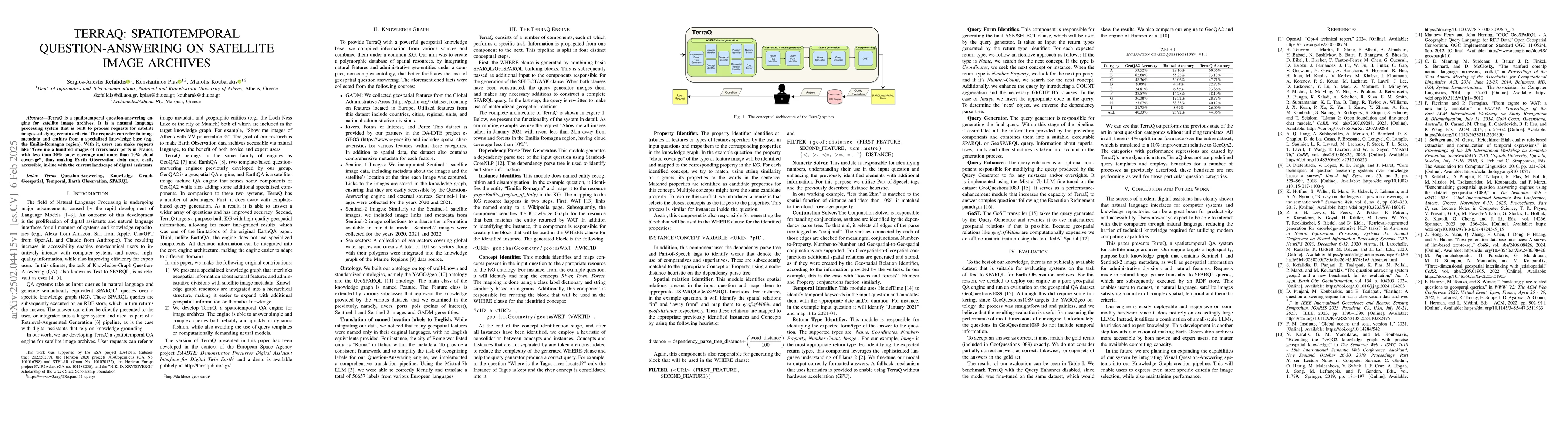
Publication

Published: Feb 06, 2025
Categories: cs.CV, cs.AI

Metrics

Source: ArXiv

Quick Actions

View PDF

AI Quick Summary

TerraQ is a natural language processing system designed for spatiotemporal question-answering on satellite image archives, enabling users to request specific images based on metadata and specialized knowledge bases. It facilitates easy access to Earth Observation data, akin to modern digital assistants.

Quick Answers

What is "TerraQ: Spatiotemporal Question-Answering on Satellite Image Archives" about?

TerraQ is a natural language processing system designed for spatiotemporal question-answering on satellite image archives, enabling users to request specific images based on metadata and specialized knowledge bases. It facilitates easy access to Earth Observation data, akin to modern digital assistants.

What methodology did the authors use?

TerraQ is a spatiotemporal question-answering engine for satellite image archives, built using a natural language processing system to process requests for satellite images based on specific criteria. It integrates a polymorphic database of spatial resources, combining natural features and administrative geo-entities under a compact, non-complex ontology for efficient geospatial question answering. More in Methodology →

What are the key results?

TerraQ outperforms previous state-of-the-art systems in most question categories without using predefined query templates. — The evaluation shows a 4% uplift in overall performance, equivalent to a 10% improvement relative to GeoQA2. More in Key Results →

Why is this work significant?

TerraQ contributes to making Earth Observation archives more accessible to both novice and expert users, regardless of their computing capacity. It advances the accessibility of digital assistants for Earth observation data, which is crucial for various applications, including environmental monitoring, urban planning, and disaster management. More in Significance →

What are the main limitations?

The paper mentions that TerraQ's heuristics do not perform as well for certain question categories due to its dynamic nature, which does not rely on predefined query templates. — The evaluation is conducted on the geospatial QA dataset GeoQuestions1089, which lacks temporal information in questions. More in Limitations →

Paper Preview

Abstract

TerraQ is a spatiotemporal question-answering engine for satellite image archives. It is a natural language processing system that is built to process requests for satellite images satisfying certain criteria. The requests can refer to image metadata and entities from a specialized knowledge base (e.g., the Emilia-Romagna region). With it, users can make requests like "Give me a hundred images of rivers near ports in France, with less than 20% snow coverage and more than 10% cloud coverage", thus making Earth Observation data more easily accessible, in-line with the current landscape of digital assistants.

AI Key Findings

Generated Jun 11, 2025

Methodology — What approach did the authors take?

TerraQ is a spatiotemporal question-answering engine for satellite image archives, built using a natural language processing system to process requests for satellite images based on specific criteria. It integrates a polymorphic database of spatial resources, combining natural features and administrative geo-entities under a compact, non-complex ontology for efficient geospatial question answering.

Key Results — What are the main findings?

  • TerraQ outperforms previous state-of-the-art systems in most question categories without using predefined query templates.
  • The evaluation shows a 4% uplift in overall performance, equivalent to a 10% improvement relative to GeoQA2.
  • TerraQ is easily deployable and responsive on commodity hardware, utilizing a combination of small-scale language models, heuristics, and expert knowledge instead of extremely large LLMs.
  • The system enables users to request satellite images satisfying complex spatial, temporal, and thematic criteria through natural language queries.

Significance — Why does this research matter?

TerraQ contributes to making Earth Observation archives more accessible to both novice and expert users, regardless of their computing capacity. It advances the accessibility of digital assistants for Earth observation data, which is crucial for various applications, including environmental monitoring, urban planning, and disaster management.

Technical Contribution — What is the technical contribution?

TerraQ's main technical contribution is its modular architecture, which breaks down the question-answering process into distinct components, each responsible for specific tasks, and propagates information from one component to the next.

Novelty — What is new about this work?

TerraQ stands out from existing research by not relying on predefined query templates and employing heuristics for various processes, enabling more flexible and dynamic question answering on satellite image archives.

Limitations — What are the limitations of this study?

  • The paper mentions that TerraQ's heuristics do not perform as well for certain question categories due to its dynamic nature, which does not rely on predefined query templates.
  • The evaluation is conducted on the geospatial QA dataset GeoQuestions1089, which lacks temporal information in questions.

Future Work — What did the authors propose for future work?

  • The authors plan to integrate Visual Question-Answering systems into the Knowledge Graph creation pipeline to allow users to express even more specific image selection criteria.
  • Expanding TerraQ's capabilities to handle a broader range of question types and improving the performance of heuristics for underperforming categories.

Paper Details

Paper ID: 2502.04415
Categories:
cs.CV cs.AI

How to Cite This Paper

BibTeX
@article{plas2025terraq,
  title         = {TerraQ: Spatiotemporal Question-Answering on Satellite Image Archives},
  author        = {Plas, Konstantinos and Koubarakis, Manolis and Kefalidis, Sergios-Anestis},
  year          = {2025},
  eprint        = {2502.04415},
  archivePrefix = {arXiv},
  primaryClass  = {cs.CV},
}
APA 7
Plas, K., Koubarakis, M., & Kefalidis, S. (2025). TerraQ: Spatiotemporal Question-Answering on Satellite Image Archives. arXiv. https://arxiv.org/abs/2502.04415
MLA 9
Plas, Konstantinos, et al. "TerraQ: Spatiotemporal Question-Answering on Satellite Image Archives." arXiv, 2025, arxiv.org/abs/2502.04415.

Similar Papers

Found 4 papers

Visual Question Answering on Image Sets

Yuting Zhang, Rama Chellappa, Ankan Bansal

2020-08-28

Analysis on Image Set Visual Question Answering

Aviral Joshi, Har Simrat Singh, Pulkit Goel et al.

2021-04-02

Multi-Image Visual Question Answering

Akhilesh Bhardwaj, Janhavi Dadhania, Prabuchandran KJ et al.

2022-02-08

No citations found for this paper.

Comments (0)

This website uses cookies to ensure you get the best experience. Learn more