ArxivLens

Publication

Published: Apr 15, 2025
Categories: cs.RO, cs.HC

Metrics

Source: ArXiv

Quick Answers

What methodology did the authors use?

The research introduces the Robotability Score ($R$), a novel metric quantifying urban environments' suitability for autonomous robot navigation. Expert interviews and surveys were conducted to identify and weigh key features contributing to $R$ for wheeled robots on urban streets. More in Methodology →

What are the key results?

Pedestrian density, crowd dynamics, and pedestrian flow are the most critical factors, collectively accounting for 28% of the total score. — Significant variation in robotability across New York City, with the highest area being 3.0 times more 'robotable' than the lowest. More in Key Results →

Why is this work significant?

This framework aims to reduce uncertainty in robot deployment while respecting established mobility patterns and urban planning principles, contributing to harmonious human-robot environments. More in Significance →

What are the main limitations?

Expert backgrounds impact feedback received, with different value sets concerning robot navigation identified. — Weight extraction using pairwise comparison methodology might be skewed towards respondents' backgrounds and professional experiences. More in Limitations →

Paper Preview

Abstract

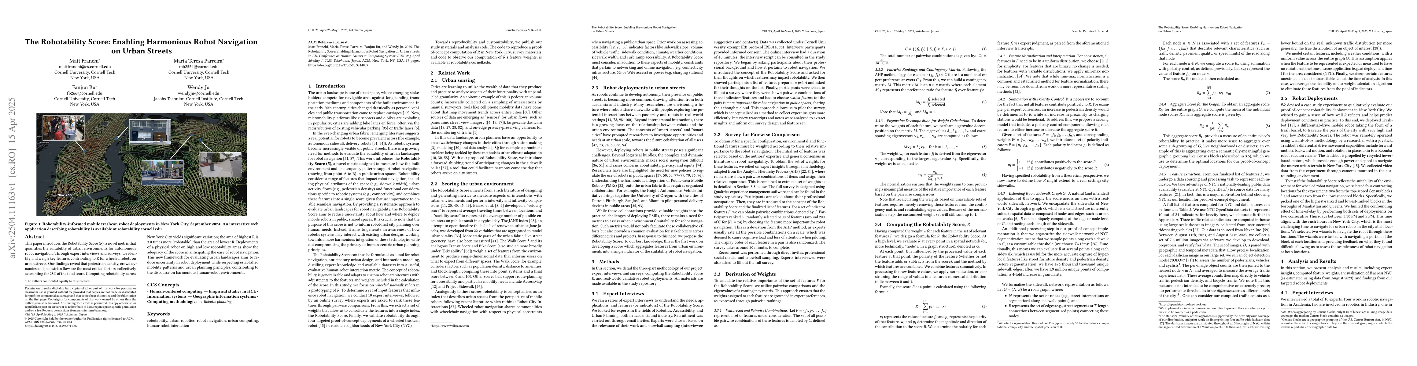
This paper introduces the Robotability Score ($R$), a novel metric that quantifies the suitability of urban environments for autonomous robot navigation. Through expert interviews and surveys, we identify and weigh key features contributing to R for wheeled robots on urban streets. Our findings reveal that pedestrian density, crowd dynamics and pedestrian flow are the most critical factors, collectively accounting for 28% of the total score. Computing robotability across New York City yields significant variation; the area of highest R is 3.0 times more "robotable" than the area of lowest R. Deployments of a physical robot on high and low robotability areas show the adequacy of the score in anticipating the ease of robot navigation. This new framework for evaluating urban landscapes aims to reduce uncertainty in robot deployment while respecting established mobility patterns and urban planning principles, contributing to the discourse on harmonious human-robot environments.

Key Findings, in focus

Seven facets of this paper, analysed and brought into focus by AI.

AI-generated · verify against source Generated Jun 09, 2025
In focus · one-line synthesis

This framework aims to reduce uncertainty in robot deployment while respecting established mobility patterns and urban planning principles, contributing to harmonious human-robot environments.

01
MethodologyHow they did it

The research introduces the Robotability Score ($R$), a novel metric quantifying urban environments' suitability for autonomous robot navigation. Expert interviews and surveys were conducted to identify and weigh key features contributing to $R$ for wheeled robots on urban streets.

02
ResultsWhat they found
  • Pedestrian density, crowd dynamics, and pedestrian flow are the most critical factors, collectively accounting for 28% of the total score.
  • Significant variation in robotability across New York City, with the highest area being 3.0 times more 'robotable' than the lowest.
03
SignificanceWhy it matters

This framework aims to reduce uncertainty in robot deployment while respecting established mobility patterns and urban planning principles, contributing to harmonious human-robot environments.

04
Technical ContributionsWhat's new technically

The Robotability Score provides a novel, anticipatory, and extensible metric for improved robot navigation, operationalizing expert knowledge and synthesizing it with extensive urban datasets.

05
NoveltyWhat sets it apart

Unlike existing metrics, the Robotability Score focuses on both infrastructure and dynamic human considerations, making it adaptable for various robot classes and types of human development.

06
LimitationsWhat to be cautious about
  • Expert backgrounds impact feedback received, with different value sets concerning robot navigation identified.
  • Weight extraction using pairwise comparison methodology might be skewed towards respondents' backgrounds and professional experiences.
07
Future WorkWhere it goes next
  • Explore the use of cell phone mobility data as a more available proxy for traffic-involved features of $R$.
  • Improve data accuracy and expand the indicator list to different civilization patterns beyond urban environments.

Impact

94
References

Paper Details

Paper ID: 2504.11163
Comments: Accepted to CHI '25
Categories:
cs.RO cs.HC

How to Cite This Paper

Reference manager: RIS EndNote

Citation Network

Current paper (gray), citations (green), references (blue)

Display is limited for performance on very large graphs.

Current Paper
Citations
References
Click to view


Discussion 0

This website uses cookies to ensure you get the best experience. Learn more