Quick Summary:

The Sand Atlas provides high-resolution 3D models of sand particles, aiding researchers with detailed morphology data, and encourages community contributions to expand knowledge on granular materials. It includes surface meshes and level-set data, supported by a Python package for data conversion.

Summary

The Sand Atlas is a publicly accessible repository dedicated to the collection, processing, and sharing of high-resolution 3D models of sand-sized particles. This dataset offers valuable insights into the morphology of a wide variety of natural and synthetic sand-sized particles from different regions, with varying mineralogy and history. The primary goal of The Sand Atlas is to support researchers, educators, and industry professionals by providing detailed, easily accessible and uniformly produced surface meshes and level-set data. The underlying code that converts volumetric data to meshes is also available via the sand-atlas python package. This platform encourages community participation, inviting contributors to share their own data and enrich the collective understanding of granular materials.

AI Key Findings

Generated Jun 11, 2025

Methodology

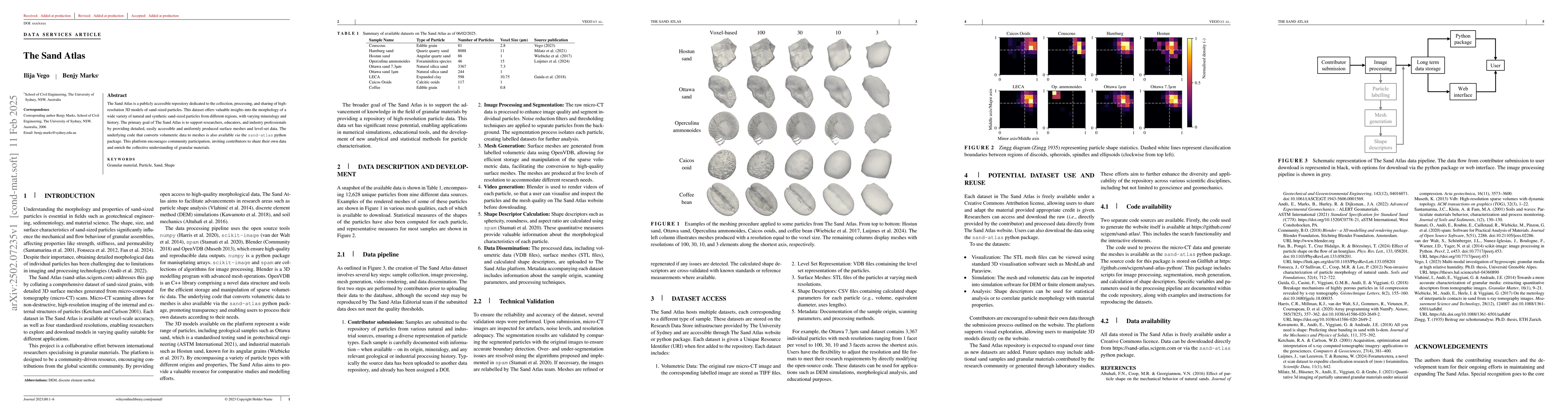
The Sand Atlas is a repository of high-resolution 3D models of sand-sized particles, offering detailed surface meshes and level-set data. It involves steps like sample collection, image processing, mesh generation, video rendering, and data dissemination. The platform encourages community participation for data contribution.

Key Results

  • Provides a publicly accessible dataset of 12,628 unique particles from nine sources.
  • Offers high-resolution surface meshes at varying levels for different research needs.

Significance

The Sand Atlas aims to advance knowledge in granular materials by providing a repository of high-resolution particle data, enabling applications in numerical simulations, educational tools, and new analytical methods for particle characterization.

Technical Contribution

The Sand Atlas provides an open-source code package (sand-atlas-python) for image processing, segmentation, mesh generation, and calculation of shape descriptors.

Novelty

The Sand Atlas is unique in its comprehensive collection of high-resolution 3D models of various sand-sized particles, along with detailed shape descriptors and open-source processing tools, fostering community-driven data contribution and research collaboration.

Limitations

  • Data is currently limited to sand-sized particles; expansion to other granular materials is planned.
  • The platform's utility depends on the quality and diversity of contributed data.

Future Work

  • Intends to expand the repository with new datasets and samples contributed by the research community.
  • Aims to enhance applicability across various scientific disciplines, including geoscience and geomechanics.

Paper Details

PDF Preview

Download PDF

Key Terms

No key terms available for this paper.

Citation Network

Current paper (gray), citations (green), references (blue)

Current Paper
Citations
References
Click to view

No citations found for this paper.

Comments (0)

This website uses cookies to ensure you get the best experience. Learn more