Quick Summary:

Summary: This paper reviews the evolution and current state of annotated datasets essential for machine learning in remote sensing, highlighting key features through selected examples and identifying challenges for future advancements.

Summary

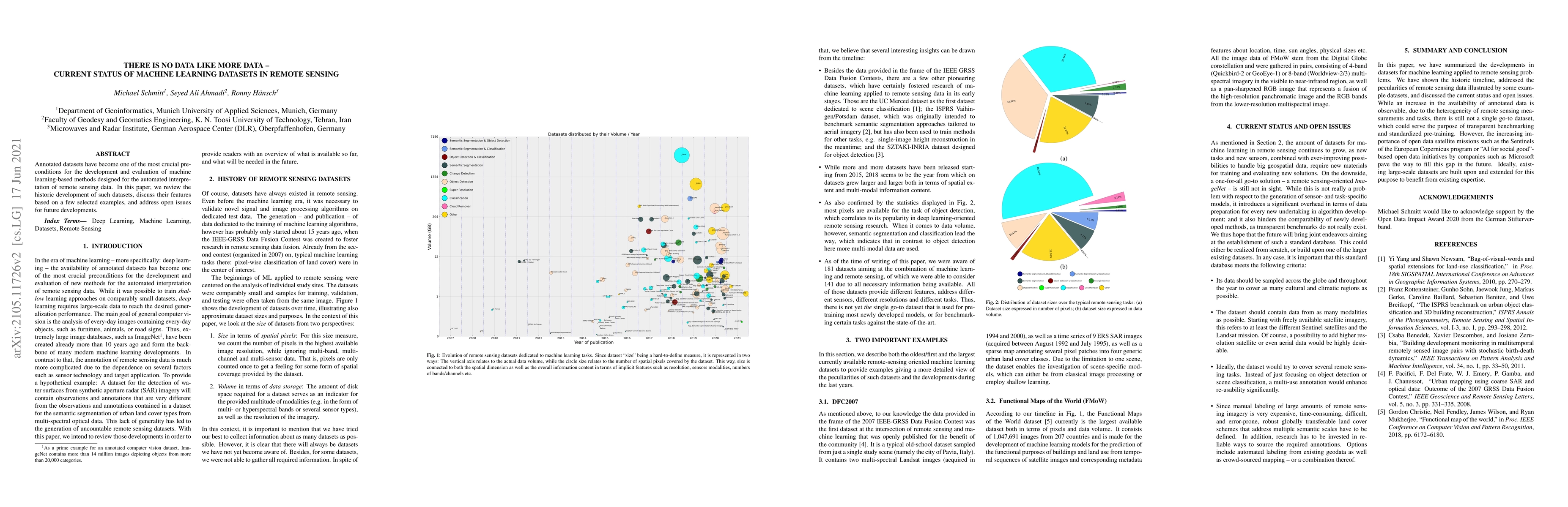
Annotated datasets have become one of the most crucial preconditions for the development and evaluation of machine learning-based methods designed for the automated interpretation of remote sensing data. In this paper, we review the historic development of such datasets, discuss their features based on a few selected examples, and address open issues for future developments.

AI Key Findings

Get AI-generated insights about this paper's methodology, results, and significance.

Paper Details

PDF Preview

Download PDF

Key Terms

issues (0.178)
designed (0.169)
machine (0.157)
future (0.151)
based (0.151)
learning (0.123)
data (0.094)
paper (0.088)

Citation Network

Current paper (gray), citations (green), references (blue)

Current Paper
Citations
References
Click to view
Title Authors Year Actions
Prefab-Net: Segmentation of prefabricated building from satellite imagery with deep neural network
Minjie Wang, Zhen Xiong, Leyong Zhang, Zhiqiang Li, Ting Chen, Zhiyong Wang, Jianjun He
2023
View Paper
A critical survey of GEOBIA methods for forest image detection and classification
Clopas Kwenda, M. V. Gwetu, Fonou-Dombeu Jean Vincent
2023
View Paper
There Are No Data Like More Data: Datasets for deep learning in Earth observation
Michael Schmitt, S. A. Ahmadi, Yonghao Xu, G. Taşkın, Ujjwal Verma, F. Sica, R. Hänsch
2023
View Paper
Multimodal camera for pedestrian detection with deep learning models
Adam Dradrach, Jakub Konert, J. Rumiński
2023
View Paper
MapInWild: A remote sensing dataset to address the question of what makes nature wild [Software and Data Sets]
Burak Ekim, T. Stomberg, R. Roscher, Michael Schmitt
2023
View Paper
Earth Observation and Artificial Intelligence: Understanding emerging ethical issues and opportunities
M. Kochupillai, Matthias Kahl, Michael Schmitt, Hannes Taubenboeck, Xiao Xiang Zhu
2022
View Paper
Quantum Based Pseudo-Labelling for Hyperspectral Imagery: A Simple and Efficient Semi-Supervised Learning Method for Machine Learning Classifiers
Riyaaz Uddien Shaik, Aiswarya Unni, Weiping Zeng
2022
View Paper
EarthNets: Empowering AI in Earth Observation
Zhitong Xiong, Fahong Zhang, Yi Wang, Yilei Shi, Xiao Xiang Zhu
2022
View Paper
EOD: The IEEE GRSS Earth Observation Database
M. Schmitt, Pedram Ghamisi, N. Yokoya, Ronny Hansch
2022
View Paper
Mapinwild: A Dataset for Global Wilderness Mapping
Burak Ekim, Michael Schmitt
2022
View Paper
Urban Building Classification (UBC) – A Dataset for Individual Building Detection and Classification from Satellite Imagery
Xingliang Huang, Libo Ren, Chenglong Liu, Yixuan Wang, Hongfeng Yu, M. Schmitt, R. Hänsch, Xian Sun, Hai Huang, H. Mayer
2022
View Paper
Accuracy and processing speed trade-offs in classical and quantum SVM classifier exploiting PRISMA hyperspectral imagery
Riyaaz Uddien Shaik, S. Periasamy
2022
View Paper
An Automatic Procedure for Forest Fire Fuel Mapping Using Hyperspectral (PRISMA) Imagery: A Semi-Supervised Classification Approach
Riyaaz Uddien Shaik, G. Laneve, L. Fusilli
2022
View Paper
A Review of Landcover Classification with Very-High Resolution Remotely Sensed Optical Images-Analysis Unit, Model Scalability and Transferability
R. Qin, Tao Liu
2022
View Paper
Quantifying Uncertainty in Slum Detection: Advancing Transfer Learning With Limited Data in Noisy Urban Environments
Thomas Stark, Michael Wurm, Xiao Xiang Zhu, H. Taubenböck
2024
View Paper
Complex-Valued End-to-End Deep Network With Coherency Preservation for Complex-Valued SAR Data Reconstruction and Classification
Reza Mohammadi Asiyabi, M. Datcu, A. Anghel, H. Nies
2023
View Paper
Training on Lexical Resources
Kenneth Ward Church, Xingyu Cai, Yuchen Bian
2022
View Paper

Comments (0)

This website uses cookies to ensure you get the best experience. Learn more