ArxivLens

Publication

Published: Feb 28, 2026
Categories: cs.NI

Metrics

Source: ArXiv

Quick Answers

What methodology did the authors use?

The study builds a high‑fidelity Digital Twin of a disaster‑affected urban area, performs site‑specific ray‑traced air‑to‑ground channel modeling with Sionna RT, and uses a Bayesian optimization engine (Tree‑structured Parzen Estimator) to search for UAV 3D placements that maximize a composite utility of coverage, sum‑rate, and fairness. The framework iteratively updates the topology in response to dynamic changes such as terrestrial... More in Methodology →

What are the key results?

TITAN achieves 32.2% higher user coverage, 64.9% higher system sum‑rate, and 49.3% higher fairness compared to the state‑of‑the‑art UAV placement method and all baselines. — After the first terrestrial base‑station failure, TITAN restores over 80% of the original sum‑rate by deploying a single UAV, and continues to maintain high service levels as additional failures occur. More in Key Results →

Why is this work significant?

By integrating deterministic, site‑specific channel knowledge with adaptive UAV placement, the framework enables reliable direct‑to‑cell satellite access in urban disaster scenarios, improving emergency communications and providing an open‑source platform for future resilient network research. More in Significance →

What are the main limitations?

The approach assumes accurate, up‑to‑date 3D environmental data and precise UAV positioning; errors in the Digital Twin or GPS can degrade performance. — High‑fidelity ray‑tracing incurs significant computational cost, limiting real‑time deployment in large‑scale or rapidly evolving environments. More in Limitations →

Paper Preview

Abstract

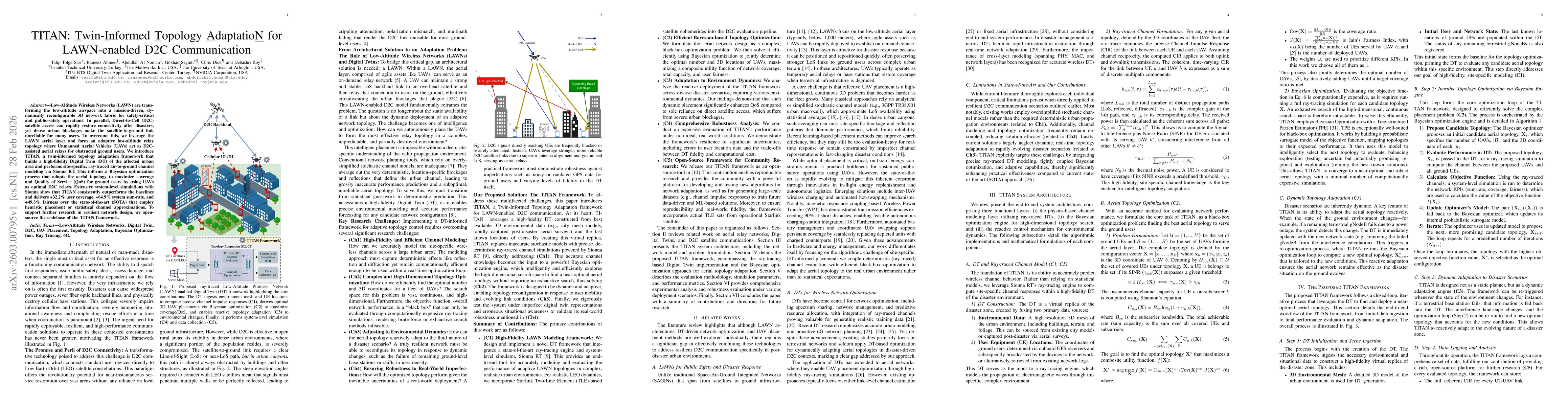
Low-Altitude Wireless Networks (LAWN) are transforming the low-altitude airspace into a mission-driven, dynamically reconfigurable 3D network fabric for safety-critical and public-safety operations. In parallel, Direct-to-Cell (D2C) satellite access can rapidly restore connectivity after disasters, yet dense urban blockages make the satellite-to-ground link unreliable for many users. To overcome this, we leverage the LAWN aerial layer and form an adaptive low-altitude relay topology where Unmanned Aerial Vehicles (UAVs) act as D2C-assisted aerial relays for obstructed ground users. We introduce TITAN, a twin-informed topology adaptation framework that builds a high-fidelity Digital Twin (DT) of the affected urban area and performs site-specific, ray-traced air-to-ground channel modeling via Sionna RT. This informs a Bayesian optimization process that adapts the aerial topology to maximize coverage and Quality of Service (QoS) for ground users by using UAVs as optimal D2C relays. Extensive system-level simulations with Sionna show that TITAN consistently outperforms the baselines and delivers +32.2% user coverage, +64.9% system sum-rate, and +49.3% fairness over the state-of-the-art (SOTA) that employ heuristic placement or statistical channel approximations. To support further research in resilient network design, we open-source the codebase of the TITAN framework.

Key Findings, in focus

Seven facets of this paper, analysed and brought into focus by AI.

AI-generated · verify against source Generated Mar 03, 2026
In focus · one-line synthesis

By integrating deterministic, site‑specific channel knowledge with adaptive UAV placement, the framework enables reliable direct‑to‑cell satellite access in urban disaster scenarios, improving emergency communications and providing an open‑source platform for future resilient network research.

01
MethodologyHow they did it

The study builds a high‑fidelity Digital Twin of a disaster‑affected urban area, performs site‑specific ray‑traced air‑to‑ground channel modeling with Sionna RT, and uses a Bayesian optimization engine (Tree‑structured Parzen Estimator) to search for UAV 3D placements that maximize a composite utility of coverage, sum‑rate, and fairness. The framework iteratively updates the topology in response to dynamic changes such as terrestrial base‑station failures, and evaluates performance through full system‑level simulations.

02
ResultsWhat they found
  • TITAN achieves 32.2% higher user coverage, 64.9% higher system sum‑rate, and 49.3% higher fairness compared to the state‑of‑the‑art UAV placement method and all baselines.
  • After the first terrestrial base‑station failure, TITAN restores over 80% of the original sum‑rate by deploying a single UAV, and continues to maintain high service levels as additional failures occur.
  • Using a low‑fidelity Digital Twin reduces optimization time by ~1.8× while still delivering over 85% of the high‑fidelity sum‑rate, demonstrating robustness to computational constraints and UE location errors.
03
SignificanceWhy it matters

By integrating deterministic, site‑specific channel knowledge with adaptive UAV placement, the framework enables reliable direct‑to‑cell satellite access in urban disaster scenarios, improving emergency communications and providing an open‑source platform for future resilient network research.

04
Technical ContributionsWhat's new technically

A closed‑loop framework that couples high‑fidelity Digital Twin‑based ray‑traced channel evaluation with Bayesian optimization for UAV topology design and dynamic adaptation, achieving near‑optimal coverage, capacity, and fairness in complex urban disaster settings.

05
NoveltyWhat sets it apart

First to combine deterministic, site‑specific propagation modeling with Bayesian topology optimization for LAWN‑enabled D2C communication, demonstrating significant performance gains over stochastic or heuristic methods and enabling real‑time adaptive deployment.

06
LimitationsWhat to be cautious about
  • The approach assumes accurate, up‑to‑date 3D environmental data and precise UAV positioning; errors in the Digital Twin or GPS can degrade performance.
  • High‑fidelity ray‑tracing incurs significant computational cost, limiting real‑time deployment in large‑scale or rapidly evolving environments.
07
Future WorkWhere it goes next
  • Incorporate dynamic environmental factors such as weather and antenna radiation patterns to further refine channel models and UAV trajectories.
  • Explore multi‑hop aerial relay networks and integration with terrestrial 5G/6G infrastructure to broaden applicability and enhance scalability.

Paper Details

Paper ID: 2603.00795
Comments: Submitted for journal publication
Categories:
cs.NI

How to Cite This Paper

Reference manager: RIS EndNote


Discussion 0

This website uses cookies to ensure you get the best experience. Learn more