ArxivLens

Quick Summary:

This paper introduces a real-time 3D wind field prediction method for UAVs and a sampling-based path planner that considers wind effects. The wind prediction reduces wind error by 23% compared to zero-wind assumptions, while the path planner, optimized for performance, consistently provides collision-free routes, especially in stronger winds.

arXiv Id: 1712.03608
Date Published: 2017-12-12
Date Updated: 2017-12-12

Categories:

Key Terms (TF-IDF):

wind (0.267)
planning (0.227)
aware (0.221)
paths (0.176)
path (0.175)
navigation (0.168)
shortest (0.166)
today (0.157)
autonomous (0.145)
collision (0.142)
follow (0.135)
real time (0.134)
sampling (0.126)
overall (0.125)
research (0.124)
environment (0.116)
prediction (0.112)
fully (0.111)
required (0.110)
real (0.107)
License: http://arxiv.org/licenses/nonexclusive-distrib/1.0/

Summary:

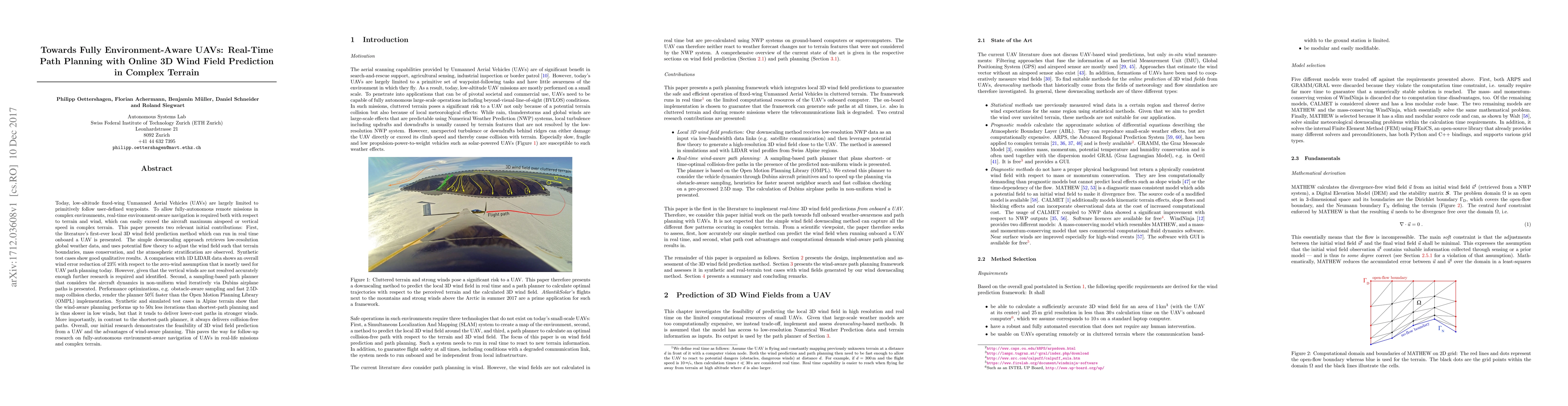
Today, low-altitude fixed-wing Unmanned Aerial Vehicles (UAVs) are largely limited to primitively follow user-defined waypoints. To allow fully-autonomous remote missions in complex environments, real-time environment-aware navigation is required both with respect to terrain and strong wind drafts. This paper presents two relevant initial contributions: First, the literature's first-ever 3D wind field prediction method which can run in real time onboard a UAV is presented. The approach retrieves low-resolution global weather data, and uses potential flow theory to adjust the wind field such that terrain boundaries, mass conservation, and the atmospheric stratification are observed. A comparison with 1D LIDAR data shows an overall wind error reduction of 23% with respect to the zero-wind assumption that is mostly used for UAV path planning today. However, given that the vertical winds are not resolved accurately enough further research is required and identified. Second, a sampling-based path planner that considers the aircraft dynamics in non-uniform wind iteratively via Dubins airplane paths is presented. Performance optimizations, e.g. obstacle-aware sampling and fast 2.5D-map collision checks, render the planner 50% faster than the Open Motion Planning Library (OMPL) implementation. Test cases in Alpine terrain show that the wind-aware planning performs up to 50x less iterations than shortest-path planning and is thus slower in low winds, but that it tends to deliver lower-cost paths in stronger winds. More importantly, in contrast to the shortest-path planner, it always delivers collision-free paths. Overall, our initial research demonstrates the feasibility of 3D wind field prediction from a UAV and the advantages of wind-aware planning. This paves the way for follow-up research on fully-autonomous environment-aware navigation of UAVs in real-life missions and complex terrain.

Citation & Reference Network Visualization

This graph shows how this paper is connected to other research. The current paper is shown in dark gray, papers that cite it are in green, and papers it references are in blue. You can:

Current Paper
Papers citing this work (Citations)
Papers cited by this work (References)

• Hover over any node to see the paper title

• Click a node to view that paper's details

• Drag nodes to rearrange the graph

• Use the zoom controls (bottom right) to zoom in/out

Citations and References

Title Authors Year Actions
Safe Periodic Trochoidal Paths for Fixed-Wing UAVs in Confined Windy Environments
Jaeyoung Lim, David Rohr, Thomas Stastny, Roland Siegwart
2025
View Paper
Autonomous Active Mapping in Steep Alpine Environments with Fixed-wing Aerial Vehicles
Jaeyoung Lim, Florian Achermann, Nicholas R. J. Lawrance, Roland Siegwart
2024
View Paper
Energy-Optimized Planning in Non-Uniform Wind Fields with Fixed-Wing Aerial Vehicles
Yufei Duan, Florian Achermann, Jaeyoung Lim, Roland Siegwart
2024
View Paper
Safe Low-Altitude Navigation in Steep Terrain With Fixed-Wing Aerial Vehicles
Jaeyoung Lim, Florian Achermann, Rik Girod, Nicholas R. J. Lawrance, Roland Siegwart
2024
View Paper
The Constructing UAV Trajectories Method Using Bezier Curves and Pythagorean Hodograph
K. Y. Ganshin, O. Mezentceva, Y. Agakhanova
2022
View Paper
Towards Finding Energy Efficient Paths for Hybrid Airships in the Atmosphere of Venus
R. Bernardo Martinez, Anna Puigvert I Juan, Guilherme A. S. Pereira
2022
View Paper
Learn to Path: Using neural networks to predict Dubins path characteristics for aerial vehicles in wind
Trevor Phillips, Maximilian Stölzle, Erick Turricelli, Florian Achermann, Nicholas R. J. Lawrance, R. Siegwart, Jen Jen Chung
2021
View Paper
Emerging approaches to support dynamic mission planning: survey and recommendations for future research
M. Henchey, S. Rosen
2020
View Paper
From Pillars to AI Technology-Based Forest Fire Protection Systems
N. Aspragathos, E. Dogkas, P. Konstantinidis, P. Koutmos, Nefeli Lamprinou, V. Moulianitis, G. Paterakis, E. Psarakis, Evangelos G. Sartinas, K. Souflas, G. Thanellas, G. Tsiourlis, N. Xanthopoulos, P. Xofis
2019
View Paper
THEASIS System for Early Detection of Wildfires in Greece: Preliminary Results from its Laboratory and Small Scale Tests
N. Aspragathos, Evangelos G. Sartinas, D. Katsaros, Stefanos Michos, Anastasios Kanavos, V. Moulianitis, E. Dogkas, P. Koutmos, G. Paterakis, K. Souflas, G. Thanellas, N. Xanthopoulos, Nefeli Lamprinou, E. Psarakis
2019
View Paper
Estimating the Vertical Structure of Weather-Induced Mission Costs for Small UAS
J. Bird, S. Richardson, J. Langelaan
2019
View Paper
General Extremal Field Method for Time-Optimal Trajectory Planning in Flow Fields
B. Schnitzler, A. Drouin, J. Moschetta, D. Delahaye
2023
View Paper
Optimal Path Planning for Aerial Robots Using Genetic Algorithm
Anna Puigvert I Juan
2023
View Paper
Wind Sensing and Estimation Using Small Fixed-Wing UAVs: A Survey
Pengzhi Tian, Haiyang Chao, M. Rhudy
2020
View Paper
Autonomous and efficient large-scale snow avalanche monitoring with an Unmanned Aerial System (UAS)
Jaeyoung Lim, Elisabeth D. Hafner, Florian Achermann, Rik Girod, David Rohr, Nicholas R. J. Lawrance, Yves Bühler, Roland Siegwart
View Paper

Comments (0)

This website uses cookies to ensure you get the best experience. Learn more