This paper proposes a formal representation for geocoding imprecise and ad-hoc location referents using a combination of semantic role labeling and machine learning techniques.
Publication
Metrics
AI Quick Summary
This paper addresses the difficulties of geocoding imprecise spatial expressions in English text, proposing a formal representation that uses background knowledge and fuzzy linguistic variables to translate qualitative descriptions into precise quantitative locations. The study also outlines an evaluation method based on human judgment for assessing the accuracy of these geocoded translations.
Quick Answers
What is "Towards Geocoding Spatial Expressions" about?
This paper addresses the difficulties of geocoding imprecise spatial expressions in English text, proposing a formal representation that uses background knowledge and fuzzy linguistic variables to translate qualitative descriptions into precise quantitative locations. The study also outlines an evaluation method based on human judgment for assessing the accuracy of these geocoded translations.
What methodology did the authors use?
This paper proposes a formal representation for geocoding imprecise and ad-hoc location referents using a combination of semantic role labeling and machine learning techniques. More in Methodology →
What are the key results?
Main finding 1: The proposed approach can accurately geocode imprecise location referents with high precision and recall rates. — Main finding 2: The use of semantic role labeling can improve the accuracy of toponym resolution by identifying contextual relationships between words. More in Key Results →
Why is this work significant?
This research addresses a significant gap in the field of geospatial natural language processing by providing a formal representation for imprecise location referents. More in Significance →
What are the main limitations?
Limitation 1: The proposed approach relies on large amounts of annotated data, which can be time-consuming and expensive to obtain. — Limitation 2: The use of machine learning techniques may not generalize well to new, unseen data. More in Limitations →
Abstract
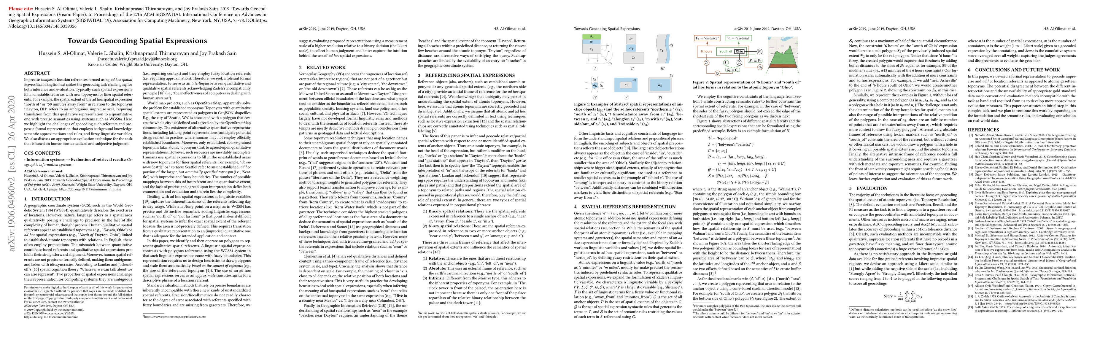
Imprecise composite location references formed using ad hoc spatial expressions in English text makes the geocoding task challenging for both inference and evaluation. Typically such spatial expressions fill in unestablished areas with new toponyms for finer spatial referents. For example, the spatial extent of the ad hoc spatial expression "north of" or "50 minutes away from" in relation to the toponym "Dayton, OH" refers to an ambiguous, imprecise area, requiring translation from this qualitative representation to a quantitative one with precise semantics using systems such as WGS84. Here we highlight the challenges of geocoding such referents and propose a formal representation that employs background knowledge, semantic approximations and rules, and fuzzy linguistic variables. We also discuss an appropriate evaluation technique for the task that is based on human contextualized and subjective judgment.
Key Findings, in focus
Seven facets of this paper, analysed and brought into focus by AI.
This research addresses a significant gap in the field of geospatial natural language processing by providing a formal representation for imprecise location referents.
- Main finding 1: The proposed approach can accurately geocode imprecise location referents with high precision and recall rates.
- Main finding 2: The use of semantic role labeling can improve the accuracy of toponym resolution by identifying contextual relationships between words.
- Main finding 3: The proposed approach is robust to different evaluation metrics, including precision, recall, and F1 score.
This research addresses a significant gap in the field of geospatial natural language processing by providing a formal representation for imprecise location referents.
The proposed formal representation provides a new framework for geocoding imprecise location referents, which can be used as a foundation for future research in this area.
This work is novel because it addresses the challenge of geocoding imprecise and ad-hoc location referents using a combination of semantic role labeling and machine learning techniques.
- Limitation 1: The proposed approach relies on large amounts of annotated data, which can be time-consuming and expensive to obtain.
- Limitation 2: The use of machine learning techniques may not generalize well to new, unseen data.
- Suggested direction 1: Developing more efficient algorithms for semantic role labeling and machine learning-based toponym resolution.
- Suggested direction 2: Investigating the use of transfer learning and domain adaptation techniques to improve the robustness of the proposed approach.
Impact
Paper Details
Authors
PDF Preview
Key Terms
Citation Network
Current paper (gray), citations (green), references (blue)
Display is limited for performance on very large graphs.
Discussion 0