Traffic Management in Smart Cities Using the Weighted Least Squares Method
Publication
Metrics
AI Quick Summary
This paper utilizes the weighted least squares method to determine the optimal placement of portable drone stations in smart cities to manage traffic congestion and respond to accidents. The goal is to identify locations that are closest to frequent traffic issues, leveraging drones for efficient emergency response and traffic control.
Paper Preview
Abstract
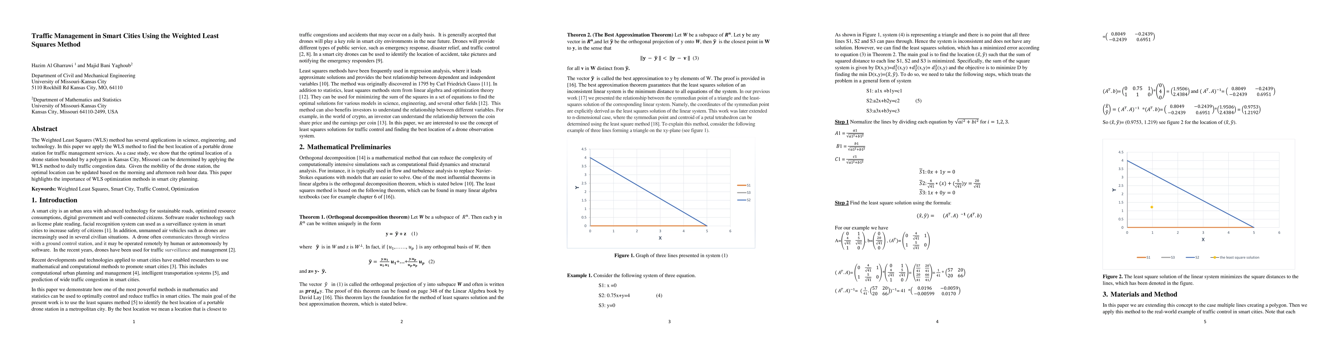
In this paper we demonstrate how one of the most powerful methods in mathematics and statistics can be used to optimally control and reduce traffics in smart cities. The main goal of the present work is to use the least squares method [5] to identify the best location of a portable drone station in a metropolitan city. By the best location we mean a location that is closest to traffic congestions and accidents that may occur on a daily basis. It is generally accepted that drones will play a key role in smart city environments in the near future. Drones will provide different types of public service, such as emergency response, disaster relief, and traffic control
AI Key Findings
Get AI-generated insights about this paper's methodology, results, significance, and more — seven facets brought into focus.
Impact
Paper Details
Authors
PDF Preview
Key Terms
Citation Network
Current paper (gray), citations (green), references (blue)
Display is limited for performance on very large graphs.
Discussion 0