Publication
Metrics
AI Quick Summary
This paper proposes a refined satellite imagery framework using UAV-derived high-resolution multispectral images and machine learning to improve precision agriculture. The refined normalized difference vegetation index (NDVI) maps better describe crop status, validated through correlation analysis and ANOVA in a vineyard case study.
Paper Preview
Abstract
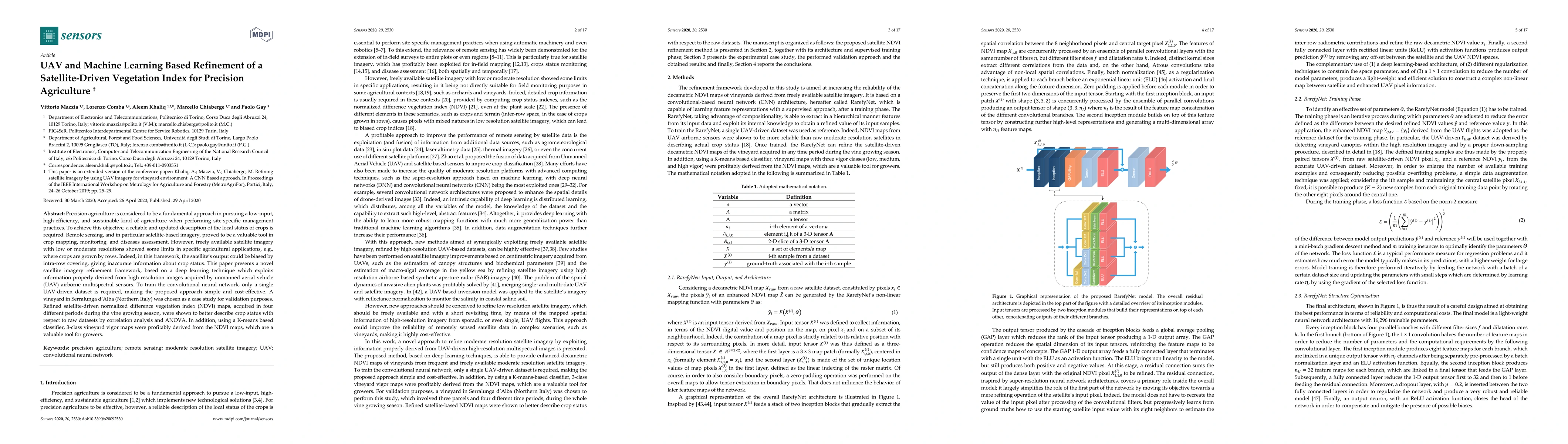
Precision agriculture is considered to be a fundamental approach in pursuing a low-input, high-efficiency, and sustainable kind of agriculture when performing site-specific management practices. To achieve this objective, a reliable and updated description of the local status of crops is required. Remote sensing, and in particular satellite-based imagery, proved to be a valuable tool in crop mapping, monitoring, and diseases assessment. However, freely available satellite imagery with low or moderate resolutions showed some limits in specific agricultural applications, e.g., where crops are grown by rows. Indeed, in this framework, the satellite's output could be biased by intra-row covering, giving inaccurate information about crop status. This paper presents a novel satellite imagery refinement framework, based on a deep learning technique which exploits information properly derived from high resolution images acquired by unmanned aerial vehicle (UAV) airborne multispectral sensors. To train the convolutional neural network, only a single UAV-driven dataset is required, making the proposed approach simple and cost-effective. A vineyard in Serralunga d'Alba (Northern Italy) was chosen as a case study for validation purposes. Refined satellite-driven normalized difference vegetation index (NDVI) maps, acquired in four different periods during the vine growing season, were shown to better describe crop status with respect to raw datasets by correlation analysis and ANOVA. In addition, using a K-means based classifier, 3-class vineyard vigor maps were profitably derived from the NDVI maps, which are a valuable tool for growers.
AI Key Findings
Get AI-generated insights about this paper's methodology, results, significance, and more — seven facets brought into focus.
Impact
Paper Details
Authors
PDF Preview
Key Terms
Citation Network
Current paper (gray), citations (green), references (blue)
Display is limited for performance on very large graphs.
Discussion 0