ArxivLens

Quick Summary:

UPDExplainer is an interpretable transformer-based framework for detecting urban physical disorders using street view imagery, leveraging a Swin Transformer model for accurate detection and a factor identification module for detailed analysis. The method achieves 79.9% detection accuracy and ranks physical disorder factors effectively, as demonstrated on the Place Pulse 2.0 dataset.

arXiv Id: 2305.02911
Date Published: 2023-05-05
Date Updated: 2023-05-05

Categories:

Key Terms (TF-IDF):

ranking (0.233)
ranking (0.233)
street (0.217)
transformer (0.172)
disorder (0.168)
disorder (0.166)
detecting (0.164)
transformer (0.162)
detecting (0.161)
gain (0.159)
gain (0.153)
physical (0.149)
physical (0.147)
detection (0.146)
detection (0.145)
maps (0.144)
precision (0.143)
view (0.143)
precision (0.142)
view (0.139)
License: http://arxiv.org/licenses/nonexclusive-distrib/1.0/

Summary:

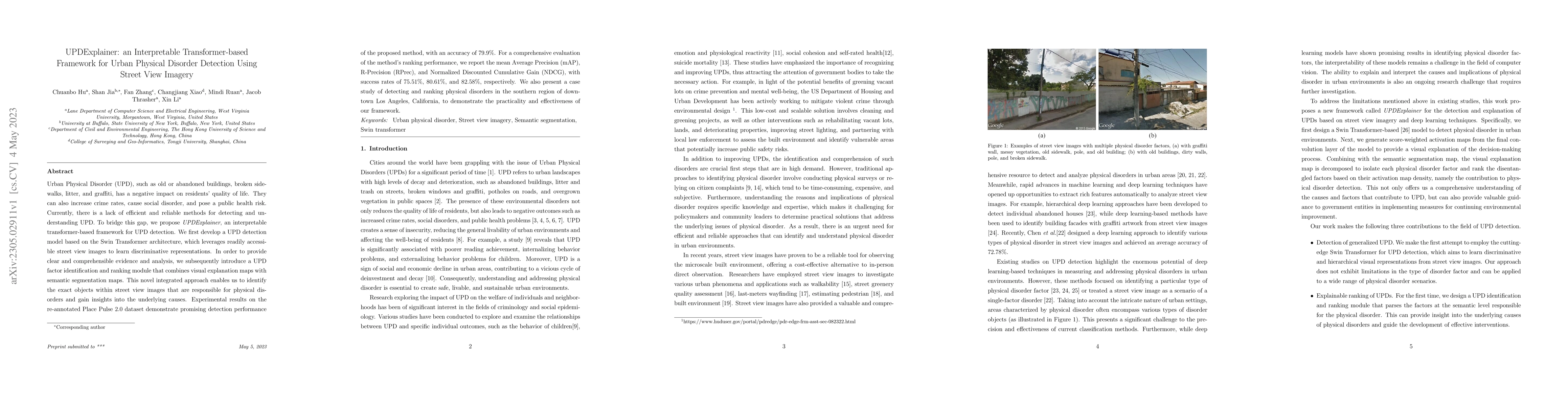
Urban Physical Disorder (UPD), such as old or abandoned buildings, broken sidewalks, litter, and graffiti, has a negative impact on residents' quality of life. They can also increase crime rates, cause social disorder, and pose a public health risk. Currently, there is a lack of efficient and reliable methods for detecting and understanding UPD. To bridge this gap, we propose UPDExplainer, an interpretable transformer-based framework for UPD detection. We first develop a UPD detection model based on the Swin Transformer architecture, which leverages readily accessible street view images to learn discriminative representations. In order to provide clear and comprehensible evidence and analysis, we subsequently introduce a UPD factor identification and ranking module that combines visual explanation maps with semantic segmentation maps. This novel integrated approach enables us to identify the exact objects within street view images that are responsible for physical disorders and gain insights into the underlying causes. Experimental results on the re-annotated Place Pulse 2.0 dataset demonstrate promising detection performance of the proposed method, with an accuracy of 79.9%. For a comprehensive evaluation of the method's ranking performance, we report the mean Average Precision (mAP), R-Precision (RPrec), and Normalized Discounted Cumulative Gain (NDCG), with success rates of 75.51%, 80.61%, and 82.58%, respectively. We also present a case study of detecting and ranking physical disorders in the southern region of downtown Los Angeles, California, to demonstrate the practicality and effectiveness of our framework.

Citation & Reference Network Visualization

This graph shows how this paper is connected to other research. The current paper is shown in dark gray, papers that cite it are in green, and papers it references are in blue. You can:

Current Paper
Papers citing this work (Citations)
Papers cited by this work (References)

• Hover over any node to see the paper title

• Click a node to view that paper's details

• Drag nodes to rearrange the graph

• Use the zoom controls (bottom right) to zoom in/out

Citations and References

Title Authors Year Actions
Different perspectives are indispensable for public space quality: Exploring the relationship between urban design quality and physical disorder
Yue Ma, Tangqi Tu, Ying Long
2025
View Paper
Measuring Temporal Evolution of Nationwide Urban Physical Disorder: An Approach Combining Time-Series Street View Imagery with Deep Learning
Yue Ma, Yan Li, Ying Long
2025
View Paper
Cross-platform complementarity: Assessing the data quality and availability of Google Street View and Baidu Street View
Lei Wang, Tianlin Zhang, Jie He, Martin Kada
2025
View Paper
A Review of the Application of Hemispherical Photography in Urban Outdoor Thermal Comfort Studies
Lei Sima, Yisha Liu, X. Shang, Qi Yuan, Yunming Zhang
2025
View Paper
Paved or unpaved? A Deep Learning derived Road Surface Global Dataset from Mapillary Street-View Imagery
Sukanya Randhawa, Eren Aygun, Guntaj Randhawa, B. Herfort, Sven Lautenbach, Alexander Zipf
2024
View Paper
From Space to Street: A Systematic Review of the Associations between Visible Greenery and Bluespace in Street View Imagery and Mental Health.
M. Bardhan, Fu Li, M. E. Browning, Jiaying Dong, Kuiran Zhang, Shuai Yuan, Hüseyin Ertan İnan, O. McAnirlin, Dani T. Dagan, Allison Maynard, Katie M. Thurson, Fan Zhang, Ruoyu Wang, Marco Helbich
2024
View Paper
URSimulator: Human-Perception-Driven Prompt Tuning for Enhanced Virtual Urban Renewal via Diffusion Models
Chuanbo Hu, Shanshan Jia, Xin Li
2024
View Paper
Pano2Geo: An efficient and robust building height estimation model using street-view panoramas
Kaixuan Fan, Anqi Lin, Hao Wu, Zhenci Xu
2024
View Paper
Measuring solar radiation and spatio-temporal distribution in different street network direction through solar trajectories and street view images
Lei Wang, Ce Hou, Yecheng Zhang, Jie He
2024
View Paper
A State-of-Art Survey on Generative AI Techniques for Floor Planning
Ankur Jain, Rana Talukdar, Avinash Kushwaha
View Paper

Comments (0)

This website uses cookies to ensure you get the best experience. Learn more