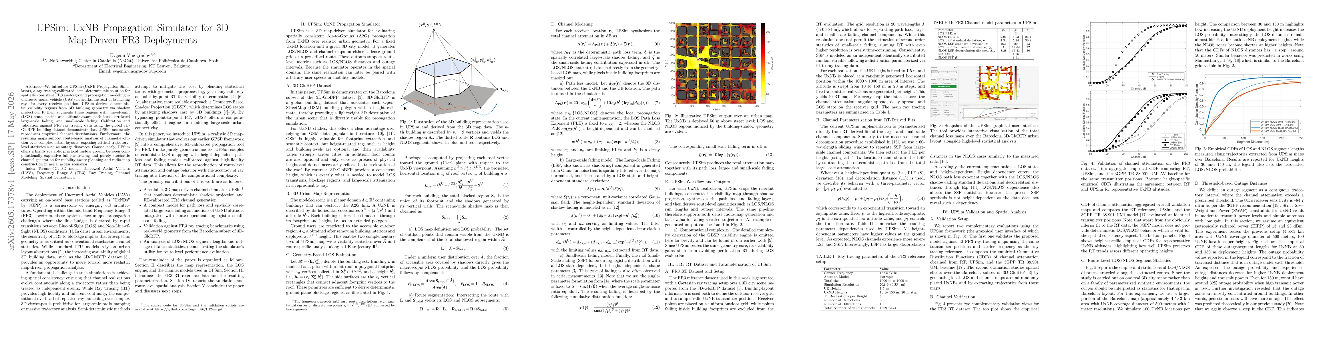
Publication

Published: May 17, 2026
Categories: eess.SP, cs.NI

Metrics

Source: ArXiv

Quick Actions

View PDF

Quick Answers

What methodology did the authors use?

UPSim adopts a 3D map-driven, semi-deterministic framework that uses geometry-based shadow projection to derive deterministic visibility regions from 3D city models, then augments these regions with altitude-aware LOS/NLOS mapping, calibrated FR3 channel models (path loss, large-scale fading, and small-scale fading) against ray tracing data from 3D-GloBFP Barcelona subset. It outputs route- and map-level visibility and channel maps, enabling route-level metrics... More in Methodology →

What are the key results?

UPSim reproduces empirical channel distributions observed in FR3 ray tracing benchmarks when calibrated with the 3D-GloBFP building dataset, demonstrating geometrically consistent channel behavior. — The framework provides route-based analysis capabilities, exposing trajectory-level statistics like LOS/NLOS segment lengths and outage distances with varyingUxNB heights. More in Key Results →

Why is this work significant?

The work delivers a scalable, map-driven propagation tool that preserves spatial continuity and route-level insights in urban FR3 A2G deployments, enabling realistic mobility-aware planning, outage analysis, and radio-map generation with significantly reduced computational cost relative to point-by-point ray tracing. More in Significance →

What are the main limitations?

Small-scale fading is altitude-aware but may require further validation across diverse urban geometries and frequencies beyond FR3. — Static city models and fixed UxNB positions limit dynamic trajectory fidelity; unmodeled temporal variations could affect accuracy during rapid maneuvers. More in Limitations →

Paper Preview

Abstract

We introduce UPSim (UxNB Propagation Simulator), a ray tracing-calibrated, semi-deterministic solution for spatially consistent FR3 air-to-ground propagation modeling in uncrewed aerial vehicle (UAV) networks. Instead of launching rays for every receiver position, UPSim derives deterministic visibility regions from 3D building geometry via shadow projection. It then augments these regions with line-of-sight (LOS) state-specific and altitude-aware path loss, correlated large-scale fading, and small-scale fading. Calibration and validation against FR3 ray tracing data using the global 3D-GloBFP building dataset demonstrate that UPSim accurately reproduces empirical channel distributions. Furthermore, the resulting maps support route-based analysis of channel evolution over complex urban layouts, exposing critical trajectory-level statistics such as outage distances. Consequently, UPSim offers a highly scalable, practical middle ground between computationally expensive full ray tracing and purely stochastic channel generation for mobility-aware planning and radio-map construction in aerial access scenarios.

AI Key Findings

Generated May 31, 2026

Methodology — What approach did the authors take?

UPSim adopts a 3D map-driven, semi-deterministic framework that uses geometry-based shadow projection to derive deterministic visibility regions from 3D city models, then augments these regions with altitude-aware LOS/NLOS mapping, calibrated FR3 channel models (path loss, large-scale fading, and small-scale fading) against ray tracing data from 3D-GloBFP Barcelona subset. It outputs route- and map-level visibility and channel maps, enabling route-level metrics such as outage distances without performing per-receiver ray tracing.

Key Results — What are the main findings?

  • UPSim reproduces empirical channel distributions observed in FR3 ray tracing benchmarks when calibrated with the 3D-GloBFP building dataset, demonstrating geometrically consistent channel behavior.
  • The framework provides route-based analysis capabilities, exposing trajectory-level statistics like LOS/NLOS segment lengths and outage distances with varyingUxNB heights.
  • Compared to full ray tracing, UPSim offers a scalable middle-ground with similar fidelity for mobility-aware planning and radio-map construction in aerial access scenarios.

Significance — Why does this research matter?

The work delivers a scalable, map-driven propagation tool that preserves spatial continuity and route-level insights in urban FR3 A2G deployments, enabling realistic mobility-aware planning, outage analysis, and radio-map generation with significantly reduced computational cost relative to point-by-point ray tracing.

Technical Contribution — What is the technical contribution?

A scalable 3D map-driven propagation simulator (UPSim) that combines deterministic shadow-projection LOS determination with FR3 channel generation calibrated against RT data, enabling spatially consistent route-level channel maps for UAV A2G networks.

Novelty — What is new about this work?

Introduces a RT-calibrated, shadow-projection–based LOS engine integrated with altitude-aware pathloss and fading models to produce spatially coherent channel maps, bridging the gap between full ray tracing and stochastic models for FR3 urban A2G scenarios.

Limitations — What are the limitations of this study?

  • Small-scale fading is altitude-aware but may require further validation across diverse urban geometries and frequencies beyond FR3.
  • Static city models and fixed UxNB positions limit dynamic trajectory fidelity; unmodeled temporal variations could affect accuracy during rapid maneuvers.
  • Calibration is performed on Barcelona subset of 3D-GloBFP; generalization to other cities with different building morphologies remains to be demonstrated.

Future Work — What did the authors propose for future work?

  • Extend spatial and frequency consistency in the small-scale fading layer to dynamic trajectories and moving UxNBs.
  • Broaden GIS-based deployment studies and measurement-driven validation across multiple cities and environments.
  • Develop data-driven Channel Knowledge Map generation to support predictive beam management and route-aware access decisions.

Paper Details

Paper ID: 2605.17378
Categories:
eess.SP cs.NI

How to Cite This Paper

BibTeX
@article{vinogradov2026upsim,
  title         = {UPSim: UxNB Propagation Simulator for 3D Map-Driven FR3 Deployments},
  author        = {Vinogradov, Evgenii},
  year          = {2026},
  eprint        = {2605.17378},
  archivePrefix = {arXiv},
  primaryClass  = {eess.SP},
}
APA 7
Vinogradov, E. (2026). UPSim: UxNB Propagation Simulator for 3D Map-Driven FR3 Deployments. arXiv. https://arxiv.org/abs/2605.17378
MLA 9
Vinogradov, Evgenii. "UPSim: UxNB Propagation Simulator for 3D Map-Driven FR3 Deployments." arXiv, 2026, arxiv.org/abs/2605.17378.

Similar Papers

Found 4 papers

Distributed local spline simulator for wave propagation

Yaomeng Li, Xu Guo, Yunfeng Xiong

2023-01-13

Physics-Informed Machine Learning Simulator for Wildfire Propagation

Luca Bottero, Valerio Pagliarino, Giovanni Graziano et al.

2020-12-15

PropSplat: Map-Free RF Field Reconstruction via 3D Gaussian Propagation Splatting

William Bjorndahl, Maninder Pal Singh, Farhad Nouri et al.

2026-05-08

Notes on Propagation of 3D Buoyant Fluid-Driven Cracks

Dmitry I. Garagash, Leonid N. Germanovich

2022-09-01

Comments (0)

This website uses cookies to ensure you get the best experience. Learn more