Quick Summary:

A new laser scanning simulation tool called HELIOS++ has been developed to simulate 3D point cloud representations of the Earth's surface with reduced computational complexity and increased flexibility.

Summary

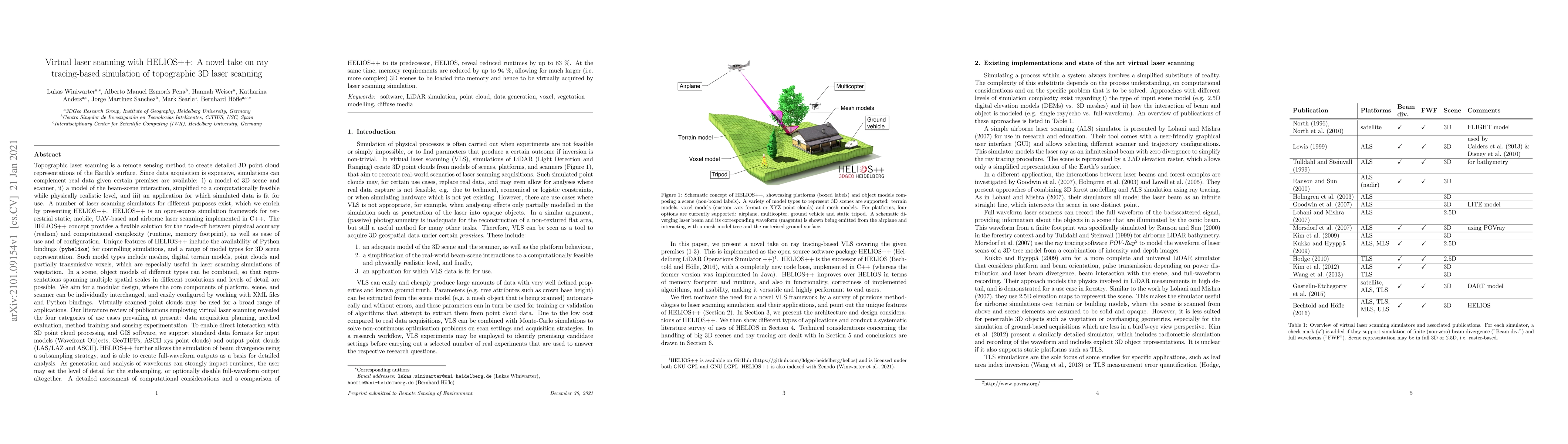
Topographic laser scanning is a remote sensing method to create detailed 3D point cloud representations of the Earth's surface. Since data acquisition is expensive, simulations can complement real data given certain premises are available: i) a model of 3D scene and scanner, ii) a model of the beam-scene interaction, simplified to a computationally feasible while physically realistic level, and iii) an application for which simulated data is fit for use. A number of laser scanning simulators for different purposes exist, which we enrich by presenting HELIOS++. HELIOS++ is an open-source simulation framework for terrestrial static, mobile, UAV-based and airborne laser scanning implemented in C++. The HELIOS++ concept provides a flexible solution for the trade-off between physical accuracy (realism) and computational complexity (runtime, memory footprint), as well as ease of use and of configuration. Unique features of HELIOS++ include the availability of Python bindings (pyhelios) for controlling simulations, and a range of model types for 3D scene representation. HELIOS++ further allows the simulation of beam divergence using a subsampling strategy, and is able to create full-waveform outputs as a basis for detailed analysis. As generation and analysis of waveforms can strongly impact runtimes, the user may set the level of detail for the subsampling, or optionally disable full-waveform output altogether. A detailed assessment of computational considerations and a comparison of HELIOS++ to its predecessor, HELIOS, reveal reduced runtimes by up to 83 %. At the same time, memory requirements are reduced by up to 94 %, allowing for much larger (i.e. more complex) 3D scenes to be loaded into memory and hence to be virtually acquired by laser scanning simulation.

AI Key Findings

Get AI-generated insights about this paper's methodology, results, and significance.

Paper Details

PDF Preview

Download PDF

Key Terms

scanning (0.248)
scanning (0.247)
scene (0.225)
laser (0.219)
scene (0.215)
laser (0.208)
waveform (0.196)
waveform (0.189)
memory (0.183)
memory (0.173)
detailed (0.165)
detailed (0.164)
create (0.156)
create (0.154)
simulation (0.154)
beam (0.150)
beam (0.147)
simulation (0.146)
reduced (0.137)
reduced (0.131)
Title Authors Year Actions
Point cloud data-based edge detection of precast concrete components for dimensional quality assessment using self-attention mechanisms
Fangxin Li, Shuyan Zhao, Ziyu Feng, Qiongfang Li, Xin Xu
2025
View Paper
Automated registration of forest point clouds from terrestrial and drone platforms using structural features
Yiliu Tan, Xin Xu, Hangkai You, Yupan Zhang, Di Wang, Yuichi Onda, Takashi Gomi, Xinwei Wang, Min Chen
2025
View Paper
Occlusion mapping reveals the impact of flight and sensing parameters on vertical forest structure exploration with cost-effective UAV based laser scanning
Matthias Gassilloud, Barbara Koch, A. Göritz
2025
View Paper
A Scalable and Efficient UAV-based Pipeline and Deep Learning Framework for Phenotyping Sorghum Panicle Morphology from Point Clouds
Chrisbin James, Shekhar S. Chandra, Scott C. Chapman
2025
View Paper
3D bridge segmentation using semi-supervised domain adaptation
Maximilian Kellner, Timothy König, Jan-Iwo Jäkel, K. Klemt‐Albert, A. Reiterer
2025
View Paper
Enhancing LiDAR point cloud generation with BRDF-based appearance modelling
Alfonso López, C. Ogáyar, R. J. Segura, Juan C. Casas-Rosa
2025
View Paper
CNN-Based Pose Estimation of a Noncooperative Spacecraft With Symmetries From LiDAR Point Clouds
Léo Renaut, Heike Frei, A. Nüchter
2025
View Paper
Building damage assessment in natural disasters: A trans- and interdisciplinary approach combining domain knowledge, 3D machine learning, and crowdsourcing
Julia Kohns, V. Zahs, Carolin Klonner, Bernhard Höfle, Lothar Stempniewski, Alexander Stark
2025
View Paper
Research on fine model reconstruction method of ancient architecture based on least squares method
Changlei Jiang, Wei Hu, Guoyu Zhang
2025
View Paper
A hybrid approach for enhanced tree volume estimation of complex trees using terrestrial LiDAR
Moonis Ali, Bharat Lohani, M. Hollaus, Norbert Pfeifer
2025
View Paper
Computer Graphics-Driven 3D LiDAR Model for Autonomous Driving Systems
Leandro E. Borgnino, Claudio Delrieux, Nicolás Salomón, Damián A. Morero
2025
View Paper
Joint 3D Point Cloud Segmentation using Real-Sim Loop: From Panels to Trees and Branches
Tian Qiu, Ruiming Du, Nikolai Spine, Lailiang Cheng, Yu Jiang
2025
View Paper
Deep learning on 3D point clouds for fast pose estimation during satellite rendezvous
Léo Renaut, Heike Frei, A. Nüchter
2025
View Paper
SK-TreePCN: Skeleton-Embedded Transformer Model for Point Cloud Completion of Individual Trees from Simulated to Real Data
Haifeng Xu, Yongjian Huai, Xun Zhao, Qingkuo Meng, Xiaoying Nie, Bowen Li, Hao Lu
2025
View Paper
TLSynth: A Novel Blender Add-On for Real-Time Point Cloud Generation from 3D Models
Emiliano Pérez, Adolfo Sánchez-Hermosell, P. Merchán
2025
View Paper
Point Cloud Wall Projection for Realistic Road Data Augmentation
Kana Kim, Sangjun Lee, Vijay Kakani, Xingyou Li, Hakil Kim
2024
View Paper
Evaluating forest aboveground biomass estimation model using simulated ALS point cloud from an individual-based forest model and 3D radiative transfer model across continents.
Zhexiu Yu, Jianbo Qi, Shangbo Liu, Xun Zhao, Huaguo Huang
2024
View Paper
Intercomparison of the DART model and GEDI simulator for simulating GEDI waveforms in forests
Ziyang Wang, Jing Liu, Yehua Sheng, Xuebo Yang
2024
View Paper
Domain adaptation of deep neural networks for tree part segmentation using synthetic forest trees
Mitch Bryson, Ahalya Ravendran, C. Mercier, T. Frickey, Sadeepa Jayathunga, Grant D. Pearse, Robin J. L. Hartley
2024
View Paper
Multi-sensor missile-borne LiDAR point cloud data augmentation based on Monte Carlo distortion simulation
Luda Zhao, Yihua Hu, Fei Han, Zhenglei Dou, Shanshan Li, Yan Zhang, Qilong Wu
2024
View Paper
LiDAR-GS:Real-time LiDAR Re-Simulation using Gaussian Splatting
Qifeng Chen, Sheng Yang, Sicong Du, Tao Tang, Peng Chen, Yuchi Huo
2024
View Paper
Completing 3D point clouds of individual trees using deep learning
Aline Bornand, M. Abegg, F. Morsdorf, Nataliia Rehush
2024
View Paper
CNN-based transfer learning for forest aboveground biomass prediction from ALS point cloud tomography
J. Schäfer, L. Winiwarter, Hannah Weiser, B. Höfle, Sebastian Schmidtlein, Jan Novotný, Grzegorz Krok, Krzysztof Stereńczak, Markus Hollaus, F. Fassnacht
2024
View Paper
Deep learning with simulated laser scanning data for 3D point cloud classification
Alberto M. Esmorís, Hannah Weiser, L. Winiwarter, J. C. Cabaleiro, B. Höfle
2024
View Paper
Domain knowledge-enhanced region growing framework for semantic segmentation of bridge point clouds
Tao Yang, Y. Zou, Xiaofei Yang, E. del Rey Castillo
2024
View Paper
Prototype pipeline modelling using interval scanning point clouds
Toa Pečur, Frédéric Bosché, G. Cerniauskas, Frank Mill, Andrew Sherlock, Nan Yu
2024
View Paper
A Depth-Buffer-Based Lidar Model With Surface Normal Estimation
Martin Kirchengast, Daniel Watzenig
2024
View Paper
SuPrNet: Super Proxy for 4D occupancy forecasting
Ao Liang, Wenyu Chen, Jian Fang, Huaici Zhao
2024
View Paper
Near-Complete Sampling of Forest Structure from High-Density Drone Lidar Demonstrated by Ray Tracing
Dafeng Zhang, Kamil Král, Martin Krůček, K. Cushman, James R. Kellner
2024
View Paper
Role of Simulated Lidar Data for Training 3D Deep Learning Models: An Exhaustive Analysis
B. Lohani, P. Khan, Vaibhav Kumar, Siddhartha Gupta
2024
View Paper
TreeNet3D : A large scale tree benchmark for 3D tree modeling, carbon storage estimation and tree segmentation
Shengjun Tang, Zhuoyu Ao, Yaoyu Li, Hongsheng Huang, L. Xie, Ruisheng Wang, Weixi Wang, Renzhong Guo
2024
View Paper
Towards digital representations for brownfield factories using synthetic data generation and 3D object detection
Javier Villena Toro, Lars Bolin, Jacob Eriksson, Anton Wiberg
2024
View Paper
Branch architecture quantification of large-scale coniferous forest plots using UAV-LiDAR data
Shangshu Cai, Wuming Zhang, Shuhang Zhang, Sisi Yu, Xinlian Liang
2024
View Paper
Efficient in-site laser scanning scheme with adaptive angular resolution for long-span bridge geometry measurement
Yan Xu, Menghui Zhao, Chaofan Xu, Yifeng Wang, Jian Zhang
2024
View Paper
Wildfire response of forest species from multispectral LiDAR data. A deep learning approach with synthetic data
Lino Comesaña-Cebral, J. Martínez-Sánchez, G. Suárez-Fernández, Pedro Arias
2024
View Paper
Transport Infrastructure Management Based on LiDAR Synthetic Data: A Deep Learning Approach with a ROADSENSE Simulator
Lino Comesaña-Cebral, J. Martínez-Sánchez, Antón Nuñez Seoane, P. Arias
2024
View Paper
LiMOX—A Point Cloud Lidar Model Toolbox Based on NVIDIA OptiX Ray Tracing Engine
Relindis Rott, David J. Ritter, Stefan Ladstätter, Oliver Nikolic, M. Hennecke
2024
View Paper
3D Reconstruction of Wheat Plants by Integrating Point Cloud Data and Virtual Design Optimization
Wenxuan Gu, Weiliang Wen, Sheng Wu, Chenxi Zheng, Xianju Lu, Wushuai Chang, Pengliang Xiao, Xinyu Guo
2024
View Paper
Individual-Tree Segmentation from UAV-LiDAR Data Using a Region-Growing Segmentation and Supervoxel-Weighted Fuzzy Clustering Approach
Yuwen Fu, Yifang Niu, Li Wang, Wang Li
2024
View Paper
Research on Ground Object Echo Simulation of Avian Lidar
Zhigang Su, Le Sang, Jingtang Hao, Bing Han, Yue Wang, Peng Ge
2024
View Paper
SegmentAnyTree: A sensor and platform agnostic deep learning model for tree segmentation using laser scanning data
Maciej Wielgosz, Stefano Puliti, Binbin Xiang, Konrad Schindler, R. Astrup
2024
View Paper
Enhancing point cloud semantic segmentation in the data‐scarce domain of industrial plants through synthetic data
F. Noichl, Fiona C. Collins, A. Braun, André Borrmann
2024
View Paper
Medium-Fidelity Evaluation and Modeling for Perception Systems of Intelligent and Connected Vehicles
Chen Sun, Yaodong Cui, Ngoc-Dũng Dào, R. V. Mehrizi, Mohammad Pirani, A. Khajepour
2024
View Paper
Assessing the potential of synthetic and ex situ airborne laser scanning and ground plot data to train forest biomass models
J. Schäfer, L. Winiwarter, Hannah Weiser, Jan Novotný, B. Höfle, Sebastian Schmidtlein, Hans Henniger, G. Krok, Krzysztof Stereńczak, F. Fassnacht
2023
View Paper
Visual programming simulator for producing realistic labeled point clouds from digital infrastructure models
Kamil Korus, Thomas Czerniawski, Marek Salamak
2023
View Paper
Evaluating the potential of airborne hyperspectral LiDAR for assessing forest insects and diseases with 3D Radiative Transfer Modeling
Xun Zhao, Jianbo Qi, Haifeng Xu, Zhexiu Yu, L. Yuan, Yiwen Chen, Huaguo Huang
2023
View Paper
Evaluating Surface Mesh Reconstruction Using Real Data
Yanis Marchand, L. Caraffa, Raphael Sulzer, Emmanuel Clédat, Bruno Vallet
2023
View Paper
GPU Rasterization-Based 3D LiDAR Simulation for Deep Learning
Leon Denis, Remco Royen, Quentin Bolsée, Nicolas Vercheval, Aleksandra Pižurica, A. Munteanu
2023
View Paper
LESS LiDAR: A Full-Waveform and Discrete-Return Multispectral LiDAR Simulator Based on Ray Tracing Algorithm
Yaotao Luo, D. Xie, Jianbo Qi, Kun Zhou, G. Yan, X. Mu
2023
View Paper
Benchmarking airborne laser scanning tree segmentation algorithms in broadleaf forests shows high accuracy only for canopy trees
Yujie Cao, James G C Ball, D. Coomes, Leon Steinmeier, Nikolai Knapp, Phil Wilkes, Mathias Disney, K. Calders, A. Burt, Yi Lin, Toby D. Jackson
2023
View Paper
Full four-dimensional change analysis of topographic point cloud time series using Kalman filtering
L. Winiwarter, K. Anders, Daniel Czerwonka-Schröder, B. Höfle
2023
View Paper
PolyGNN: Polyhedron-based Graph Neural Network for 3D Building Reconstruction from Point Clouds
Zhaiyu Chen, Yilei Shi, L. Nan, Zhitong Xiong, Xiao Xiang Zhu
2023
View Paper
Polyhedron-Based Graph Neural Network for Compact Building Model Reconstruction
Zhaiyu Chen, Yilei Shi, Zhitong Xiong, Xiao Xiang Zhu
2023
View Paper
Investigating the Impact of Point Cloud Density on Semantic Segmentation Performance Using Virtual Lidar in Boreal Forest
Olivier Stocker, Reza Mahmoudi Kouhi, Éric Guilbert, Antonio Ferraz, Thierry Badard
2023
View Paper
Saint Petersburg 3D: Creating a Large-Scale Hybrid Mobile LiDAR Point Cloud Dataset for Geospatial Applications
S. Lytkin, V. Badenko, A. Fedotov, K. Vinogradov, Anton Chervak, Yevgeny Milanov, D. Zotov
2023
View Paper
Remote sensing in forestry: current challenges, considerations and directions
F. Fassnacht, Joanne C. White, M. Wulder, E. Næsset
2023
View Paper
Neural LiDAR Fields for Novel View Synthesis
S. Huang, Zan Gojcic, Zian Wang, Francis Williams, Yoni Kasten, S. Fidler, K. Schindler, O. Litany
2023
View Paper
Generating synthetic laser scanning data of forests by combining forest inventory information, a tree point cloud database and an open-source laser scanning simulator
J. Schäfer, Hannah Weiser, L. Winiwarter, B. Höfle, S. Schmidtlein, F. Fassnacht
2023
View Paper
Classification of structural building damage grades from multi-temporal photogrammetric point clouds using a machine learning model trained on virtual laser scanning data
V. Zahs, K. Anders, Julia Kohns, Alexander Stark, B. Höfle
2023
View Paper
Point Density Variations in Airborne Lidar Point Clouds
V. Petras, A. Petrasova, J. McCarter, H. Mitásová, R. Meentemeyer
2023
View Paper
Tree segmentation in airborne laser scanning data is only accurate for canopy trees
Yujie Cao, James G. C. Ball, D. Coomes, Leon Steinmeier, Nikolai Knapp, P. Wilkes, M. Disney, K. Calders, A. Burt, Yi Lin, Tobias Jackson
2022
View Paper
A novel entropy-based method to quantify forest canopy structural complexity from multiplatform lidar point clouds
Xiaoqiang Liu, Q. Ma, Xiaoyong Wu, T. Hu, Zhonghua Liu, Lingli Liu, Q. Guo, Yanjun Su
2022
View Paper
Evaluating Data Inter-Operability of Multiple UAV-LiDAR Systems for Measuring the 3D Structure of Savanna Woodland
H. Bartholomeus, K. Calders, T. Whiteside, L. Terryn, Sruthi M. Krishna Moorthy, S. Levick, R. Bartolo, H. Verbeeck
2022
View Paper
Peering through the thicket: Effects of UAV LiDAR scanner settings and flight planning on canopy volume discovery
Benjamin Brede, H. Bartholomeus, N. Barbier, F. Pimont, Grégoire Laurent Vincent, M. Herold
2022
View Paper
Enhancing Railway Detection by Priming Neural Networks with Project Exaptations
Felix Eickeler, A. Borrmann
2022
View Paper
SIMULATING LIDAR TO CREATE TRAINING DATA FOR MACHINE LEARNING ON 3D POINT CLOUDS
J. Hildebrand, S. Schulz, R. Richter, J. Döllner
2022
View Paper
Reducing domain shift in synthetic data augmentation for semantic segmentation of 3D point clouds
Romain Cazorla, L. Poinel, Panagiotis Papadakis, Cédric Buche
2022
View Paper
POINT CLOUD SIMULATOR FOR SPACE IN-ORBIT CLOSE RANGE AUTONOMOUS OPERATIONS
L. M. González-deSantos, H. González-Jorge, M. Sanjurjo-Rivo, H. Michinel
2022
View Paper
VIRTUAL LASER SCANNING OF DYNAMIC SCENES CREATED FROM REAL 4D TOPOGRAPHIC POINT CLOUD DATA
L. Winiwarter, K. Anders, D. Schröder, B. Höfle
2022
View Paper
Synthetic Point Cloud Generation for Class Segmentation Applications
Maria Gonzalez Stefanelli, A. Jain, Sandeep Kamal Jalui, E. Agapaki
2022
View Paper
Digital Twin Framework for Enabling Serial Construction
Simon Kosse, O. Vogt, M. Wolf, M. König, Detlef Gerhard
2022
View Paper
Individual tree point clouds and tree measurements from multi-platform laser scanning in German forests
Hannah Weiser, J. Schäfer, L. Winiwarter, Nina Krašovec, F. Fassnacht, B. Höfle
2022
View Paper
Evaluating the Quality of Semantic Segmented 3D Point Clouds
Eike Barnefske, H. Sternberg
2022
View Paper
Assessing inclination angles of tree branches from terrestrial laser scan data using a skeleton extraction method
Bingxiao Wu, G. Zheng, Yang Chen, Dongsheng Yu
2021
View Paper
Opaque voxel-based tree models for virtual laser scanning in forestry applications
Hannah Weiser, L. Winiwarter, K. Anders, F. Fassnacht, B. Höfle
2021
View Paper
BLAINDER—A Blender AI Add-On for Generation of Semantically Labeled Depth-Sensing Data
Stefan Reitmann, Lorenzo Neumann, Bernhard Jung
2021
View Paper
SPTNet: Sparse Convolution and Transformer Network for Woody and Foliage Components Separation From Point Clouds
Shuai Zhang, Yiping Chen, Biao Wang, Dong Pan, Wuming Zhang, Aiguang Li
2024
View Paper
Finding geometric and topological similarities in building elements for large-scale pose updates in Scan-vs-BIM
Fiona C. Collins, A. Braun, A. Borrmann
2023
View Paper
Validation of the DART Model for Airborne Laser Scanner Simulations on Complex Forest Environments
Florian de Boissieu, Florence Heuschmidt, N. Lauret, Dav M. Ebengo, Grégoire Laurent Vincent, J. Féret, T. Yin, J. Gastellu‐Etchegorry, Josiane Costeraste, M. Lefèvre-Fonollosa, S. Durrieu
2023
View Paper
Virtual LiDAR Simulation as a High Performance Computing Challenge: Toward HPC HELIOS++
Alberto M. Esmorís, M. Yermo, Hannah Weiser, L. Winiwarter, B. Höfle, F. F. Rivera
2022
View Paper
Graph-Based Leaf–Wood Separation Method for Individual Trees Using Terrestrial Lidar Point Clouds
Zhilin Tian, Shihua Li
2022
View Paper
Machine Learning Based Methods for Virtual Validation of Autonomous Driving
T. Johansson
2021
View Paper
A dvancing vegetation monitoring with virtual laser scanning of dynamic scenes (VLS-4D): O pportunities , implementations and future perspectives
Hannah Weiser, Bernhard Höfle
View Paper
TwinGen: Advanced technologies to automatically generate digital twins for operation and maintenance of existing bridges
M. S. M. S. Vilgertshofer, A. Borrmann, J. Martens, T. Blut, R. Becker, J. Blankenbach, A. G¨obels, J. Beetz, F. Celik, B. Faltin, M. K¨onig
View Paper
Reconstructing the fine-scale habitat structure of wetlands for animal ecology using remote sensing
View Paper

Comments (0)

This website uses cookies to ensure you get the best experience. Learn more