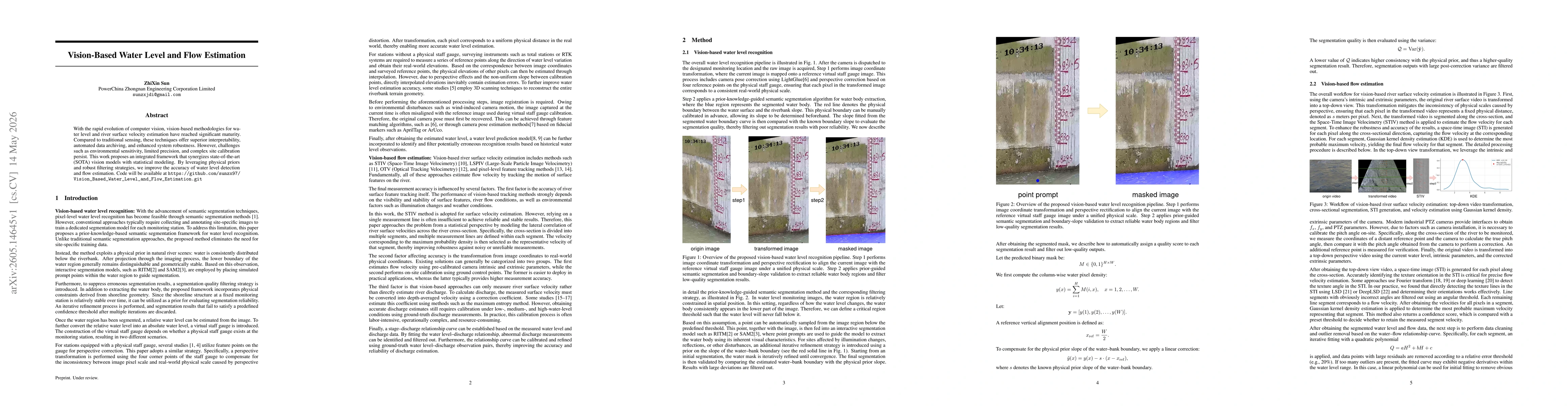
Vision-Based Water Level and Flow Estimation

PDF

Authors

Publication

Published: May 14, 2026
Categories: cs.CV, cs.AI

Metrics

Source: ArXiv

Quick Actions

View PDF

Quick Answers

What methodology did the authors use?

The work combines state-of-the-art vision models with statistical modeling, leveraging physical priors (shoreline geometry) and robust filtering, plus a virtual staff gauge or reference points for absolute water level, and a cross-sectional multi-line velocity estimation using STIV with a probabilistic selection of segment velocities. More in Methodology →

What are the key results?

An integrated framework improves water level detection accuracy by incorporating physical priors and iterative segmentation quality filtering. — Surface velocity estimation is enhanced by cross-sectional segmentation and a maximum a posteriori approach over multiple measurement lines, increasing robustness to noise. More in Key Results →

Why is this work significant?

The approach offers improved accuracy and robustness for vision-based water level and river surface velocity estimation by fusing vision with physical priors and statistical modeling, potentially reducing reliance on extensive site-specific training data and enabling automated data archiving and interpretability. More in Significance →

What are the main limitations?

Environmental sensitivity and varying illumination can still impact feature visibility and segmentation reliability. — On-site calibration complexities remain for some configurations, especially when physical staff gauges are unavailable. More in Limitations →

Paper Preview

Abstract

With the rapid evolution of computer vision, vision-based methodologies for water level and river surface velocity estimation have reached significant maturity. Compared to traditional sensing, these techniques offer superior interpretability, automated data archiving, and enhanced system robustness. However, challenges such as environmental sensitivity, limited precision, and complex site calibration persist. This work proposes an integrated framework that synergizes state-of-the-art (SOTA) vision models with statistical modeling. By leveraging physical priors and robust filtering strategies, we improve the accuracy of water level detection and flow estimation. Code will be available at https://github.com/sunzx97/Vision_Based_Water_Level_and_Flow_Estimation.git

AI Key Findings

Generated May 31, 2026

Methodology — What approach did the authors take?

The work combines state-of-the-art vision models with statistical modeling, leveraging physical priors (shoreline geometry) and robust filtering, plus a virtual staff gauge or reference points for absolute water level, and a cross-sectional multi-line velocity estimation using STIV with a probabilistic selection of segment velocities.

Key Results — What are the main findings?

  • An integrated framework improves water level detection accuracy by incorporating physical priors and iterative segmentation quality filtering.
  • Surface velocity estimation is enhanced by cross-sectional segmentation and a maximum a posteriori approach over multiple measurement lines, increasing robustness to noise.
  • Relative water levels can be transformed to absolute levels via virtual staff gauge or distributed reference points, enabling real-world calibration.

Significance — Why does this research matter?

The approach offers improved accuracy and robustness for vision-based water level and river surface velocity estimation by fusing vision with physical priors and statistical modeling, potentially reducing reliance on extensive site-specific training data and enabling automated data archiving and interpretability.

Technical Contribution — What is the technical contribution?

A novel integration of SOTA vision models with physical priors and robust filtering for water level and flow estimation, plus a statistical framework to fuse multi-line velocity measurements and a virtual staff gauge for absolute calibration.

Novelty — What is new about this work?

Introduces a physics-informed, segmentation-filtered, multi-line flow estimation pipeline in a vision-based setting, incorporating virtual staff gauges and cross-sectional probabilistic velocity selection to enhance accuracy and robustness.

Limitations — What are the limitations of this study?

  • Environmental sensitivity and varying illumination can still impact feature visibility and segmentation reliability.
  • On-site calibration complexities remain for some configurations, especially when physical staff gauges are unavailable.

Future Work — What did the authors propose for future work?

  • Extend robust segmentation filtering with stronger priors and uncertainty quantification to handle extreme environmental conditions.
  • Improve cross-section modeling to capture complex river morphologies and flow regimes.
  • Automate calibration workflows further, reducing dependency on ground-truth references for broader deployment.

Paper Details

Paper ID: 2605.14645
Categories:
cs.CV cs.AI

How to Cite This Paper

BibTeX
@article{sun2026vision,
  title         = {Vision-Based Water Level and Flow Estimation},
  author        = {Sun, ZhiXin},
  year          = {2026},
  eprint        = {2605.14645},
  archivePrefix = {arXiv},
  primaryClass  = {cs.CV},
}
APA 7
Sun, Z. (2026). Vision-Based Water Level and Flow Estimation. arXiv. https://arxiv.org/abs/2605.14645
MLA 9
Sun, ZhiXin. "Vision-Based Water Level and Flow Estimation." arXiv, 2026, arxiv.org/abs/2605.14645.

Comments (0)

This website uses cookies to ensure you get the best experience. Learn more