Researchers develop a method to efficiently visualize large spatial data sets using a sampling technique that reduces errors compared to random sampling, enabling accurate kernel density estimates.
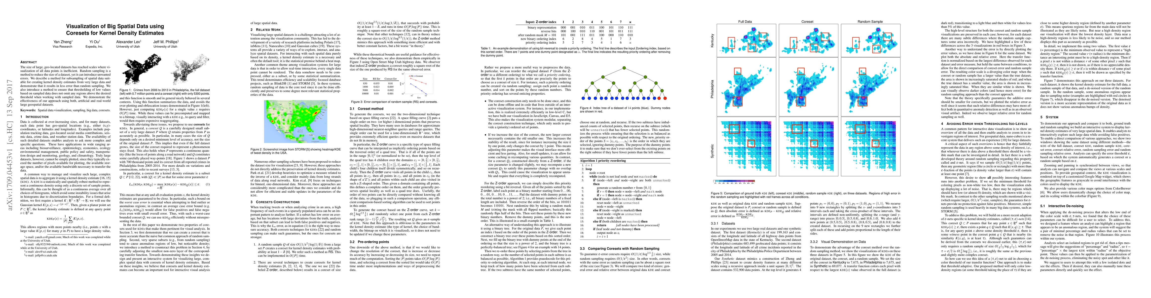
The size of large, geo-located datasets has reached scales where visualization of all data points is inefficient. Random sampling is a method to reduce the size of a dataset, yet it can introduce unwanted errors. We describe a method for subsampling of spatial data suitable for creating kernel density estimates from very large data and demonstrate that it results in less error than random sampling. We also introduce a method to ensure that thresholding of low values based on sampled data does not omit any regions above the desired threshold when working with sampled data. We demonstrate the effectiveness of our approach using both, artificial and real-world large geospatial datasets.
Generated Sep 05, 2025
The research used a method for subsampling of spatial data suitable for creating kernel density estimates from very large datasets.
The approach is important for creating kernel density estimates from large geospatial datasets and has potential impact on visualization and analysis.
The research introduces a novel method for subsampling spatial data suitable for creating kernel density estimates from very large datasets.
The approach combines coreset sampling with thresholding to ensure accurate visualization of regions above the desired threshold.
Current paper (gray), citations (green), references (blue)
Display is limited for performance on very large graphs.
Yubo Zhang, Shaofeng H. -C. Jiang, Robert Krauthgamer et al.
Title | Authors | Year | Actions |
---|
Comments (0)