Summary
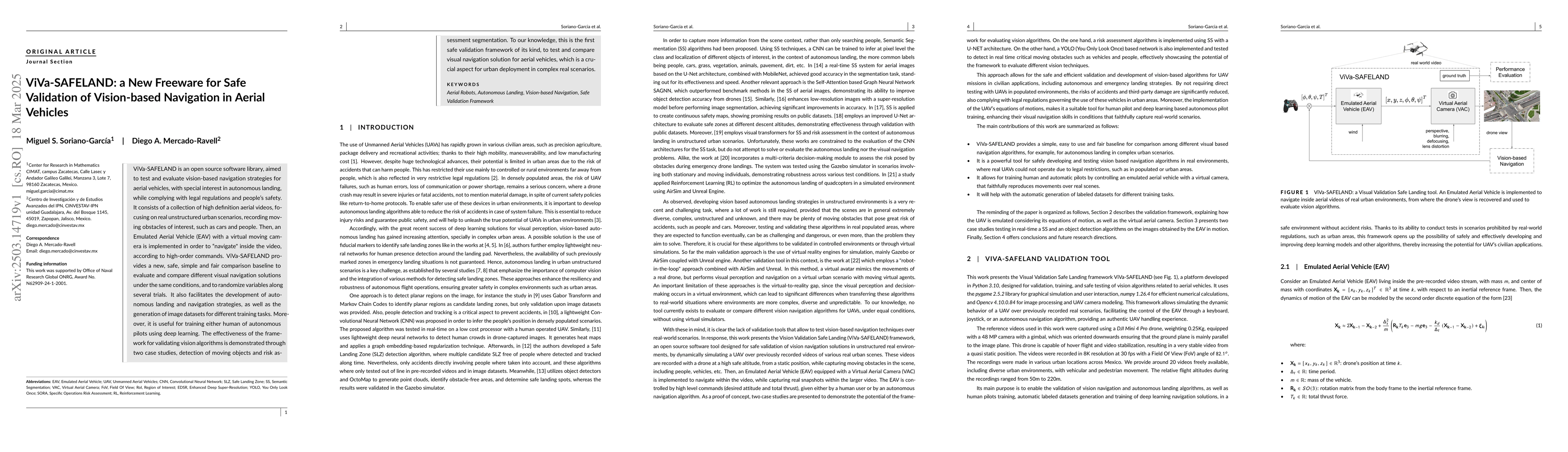
ViVa-SAFELAND is an open source software library, aimed to test and evaluate vision-based navigation strategies for aerial vehicles, with special interest in autonomous landing, while complying with legal regulations and people's safety. It consists of a collection of high definition aerial videos, focusing on real unstructured urban scenarios, recording moving obstacles of interest, such as cars and people. Then, an Emulated Aerial Vehicle (EAV) with a virtual moving camera is implemented in order to ``navigate" inside the video, according to high-order commands. ViVa-SAFELAND provides a new, safe, simple and fair comparison baseline to evaluate and compare different visual navigation solutions under the same conditions, and to randomize variables along several trials. It also facilitates the development of autonomous landing and navigation strategies, as well as the generation of image datasets for different training tasks. Moreover, it is useful for training either human of autonomous pilots using deep learning. The effectiveness of the framework for validating vision algorithms is demonstrated through two case studies, detection of moving objects and risk assessment segmentation. To our knowledge, this is the first safe validation framework of its kind, to test and compare visual navigation solution for aerial vehicles, which is a crucial aspect for urban deployment in complex real scenarios.
AI Key Findings
Generated Jun 10, 2025
Methodology
ViVa-SAFELAND is a freeware tool that emulates an aerial vehicle (EAV) navigating within high-definition aerial videos of real urban scenarios, using a virtual aerial camera (VAC) to simulate drone view and ground truth. It incorporates super-resolution techniques for enhancing low-quality images captured by the VAC as the EAV approaches the ground.
Key Results
- ViVa-SAFELAND provides a safe, simple, and fair comparison baseline for evaluating and comparing different visual navigation solutions under controlled conditions.
- The framework facilitates the development of autonomous landing and navigation strategies, as well as the generation of image datasets for training tasks.
- Two case studies demonstrated the effectiveness of the framework: semantic segmentation for risk assessment and object detection using YOLOv8 model.
- The first case study showcased a U-Net network trained to assign pixel-level risk levels, while the second case study integrated a YOLOv8 model to detect critical objects like vehicles, people, motorcycles, and bicycles.
Significance
This research is significant as it introduces the first safe validation framework for testing and comparing visual navigation solutions for aerial vehicles, crucial for urban deployment in complex real scenarios. It enables the development and improvement of deep learning models and other algorithms in a secure and efficient manner, increasing the potential for UAVs' civilian applications.
Technical Contribution
ViVa-SAFELAND's technical contributions include the implementation of an Emulated Aerial Vehicle (EAV) and Virtual Aerial Camera (VAC) for safe validation of vision-based navigation strategies, along with a super-resolution network to enhance low-quality images captured by the VAC.
Novelty
ViVa-SAFELAND is novel as it is the first safe validation framework for testing and comparing visual navigation solutions for aerial vehicles in real unstructured urban scenarios, providing a controlled environment for developing and improving deep learning models and other algorithms without compromising safety.
Limitations
- The paper does not explicitly mention any limitations of the ViVa-SAFELAND framework.
- The effectiveness of the framework is demonstrated through only two case studies, which might not fully represent its capabilities across diverse scenarios.
Future Work
- Expanding the framework's capabilities to incorporate advanced algorithms for aerial image segmentation.
- Developing fully autonomous navigation algorithms using visual feedback.
- Creating a more extensive dataset for validation and training purposes.
Paper Details
PDF Preview
Citation Network
Current paper (gray), citations (green), references (blue)
Display is limited for performance on very large graphs.
Similar Papers
Found 4 papersAerial Vision-and-Dialog Navigation
Yi Zhang, Tongzhou Jiang, Xin Eric Wang et al.
Autonomous and Adaptive Navigation for Terrestrial-Aerial Bimodal Vehicles
Fei Gao, Chao Xu, Lixian Zhang et al.
Analysis of the Effect of Time Delay for Unmanned Aerial Vehicles with Applications to Vision Based Navigation
Yahya Zweiri, Mohamad Chehadeh, Igor Boiko et al.
No citations found for this paper.
Comments (0)