ArxivLens

Publication

Published: Jun 20, 2025
Updated: Aug 04, 2025
Categories: cs.RO

Metrics

Source: ArXiv

Quick Answers

What methodology did the authors use?

The proposed approach uses a Vision-Language Model for terrain complexity classification, demonstrating superior performance in complex environments. More in Methodology →

What are the key results?

Main finding 1: The proposed approach outperforms traditional geometric perception methods in planetary navigation. — Main finding 2: The method offers enhanced flexibility, allowing task-specific and vehicle-specific adaptation. More in Key Results →

Why is this work significant?

This research is important as it addresses the need for advanced planetary navigation systems that can efficiently handle complex environments. More in Significance →

What are the main limitations?

Limitation 1: The current algorithmic implementation focuses primarily on geometric properties of the terrain, with limited attention paid to semantic aspects. — Limitation 2: Further refinement of the algorithms is necessary to ensure robustness in different real-world environments. More in Limitations →

Paper Preview

Abstract

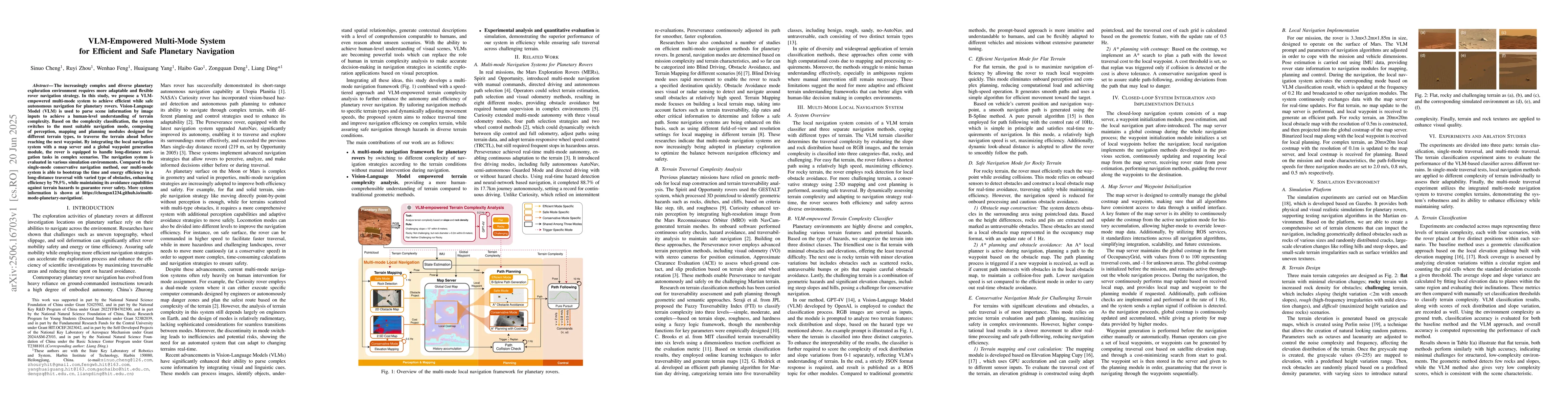
The increasingly complex and diverse planetary exploration environment requires more adaptable and flexible rover navigation strategy. In this study, we propose a VLM-empowered multi-mode system to achieve efficient while safe autonomous navigation for planetary rovers. Vision-Language Model (VLM) is used to parse scene information by image inputs to achieve a human-level understanding of terrain complexity. Based on the complexity classification, the system switches to the most suitable navigation mode, composing of perception, mapping and planning modules designed for different terrain types, to traverse the terrain ahead before reaching the next waypoint. By integrating the local navigation system with a map server and a global waypoint generation module, the rover is equipped to handle long-distance navigation tasks in complex scenarios. The navigation system is evaluated in various simulation environments. Compared to the single-mode conservative navigation method, our multi-mode system is able to bootstrap the time and energy efficiency in a long-distance traversal with varied type of obstacles, enhancing efficiency by 79.5%, while maintaining its avoidance capabilities against terrain hazards to guarantee rover safety. More system information is shown at https://chengsn1234.github.io/multi-mode-planetary-navigation/.

Key Findings, in focus

Seven facets of this paper, analysed and brought into focus by AI.

AI-generated · verify against source Generated Sep 04, 2025
In focus · one-line synthesis

This research is important as it addresses the need for advanced planetary navigation systems that can efficiently handle complex environments.

01
MethodologyHow they did it

The proposed approach uses a Vision-Language Model for terrain complexity classification, demonstrating superior performance in complex environments.

02
ResultsWhat they found
  • Main finding 1: The proposed approach outperforms traditional geometric perception methods in planetary navigation.
  • Main finding 2: The method offers enhanced flexibility, allowing task-specific and vehicle-specific adaptation.
  • Main finding 3: The system dynamically adjusts the navigation mode based on terrain features, enhancing efficiency while maintaining safety.
03
SignificanceWhy it matters

This research is important as it addresses the need for advanced planetary navigation systems that can efficiently handle complex environments.

04
Technical ContributionsWhat's new technically

The proposed approach provides a novel solution for planetary navigation, leveraging advanced machine learning techniques and semantic understanding of terrain features.

05
NoveltyWhat sets it apart

What makes this work novel or different from existing research is its emphasis on combining vision-language models with terrain complexity classification for efficient and safe planetary navigation.

06
LimitationsWhat to be cautious about
  • Limitation 1: The current algorithmic implementation focuses primarily on geometric properties of the terrain, with limited attention paid to semantic aspects.
  • Limitation 2: Further refinement of the algorithms is necessary to ensure robustness in different real-world environments.
07
Future WorkWhere it goes next
  • Suggested direction 1: Refine the algorithms for improved robustness and adaptability in various environmental conditions.
  • Suggested direction 2: Integrate additional sensory data sources to enhance the system's overall performance and accuracy.

Impact

19
References

Paper Details

Paper ID: 2506.16703
Comments: accepted by IROS 2025
Categories:
cs.RO

How to Cite This Paper

Reference manager: RIS EndNote

Citation Network

Current paper (gray), citations (green), references (blue)

Display is limited for performance on very large graphs.

Current Paper
Citations
References
Click to view


Discussion 0

This website uses cookies to ensure you get the best experience. Learn more