Summary

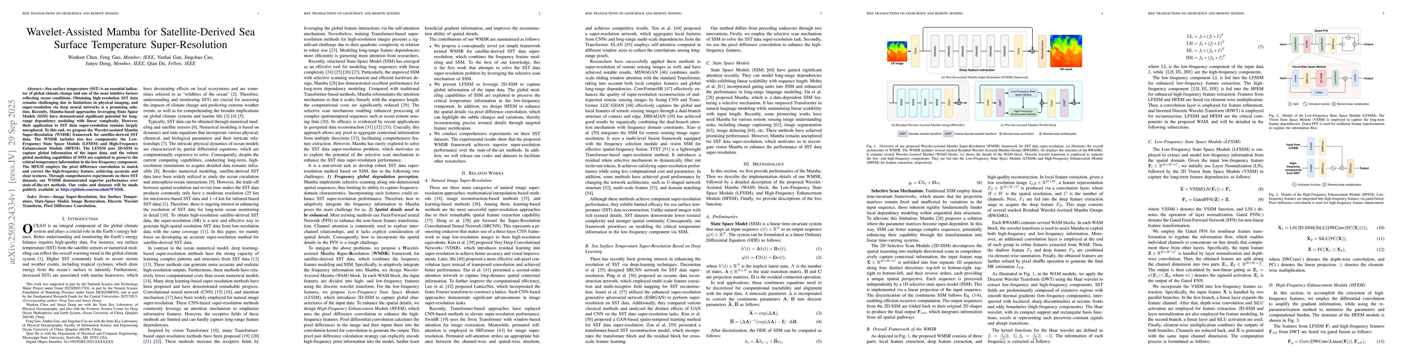
Sea surface temperature (SST) is an essential indicator of global climate change and one of the most intuitive factors reflecting ocean conditions. Obtaining high-resolution SST data remains challenging due to limitations in physical imaging, and super-resolution via deep neural networks is a promising solution. Recently, Mamba-based approaches leveraging State Space Models (SSM) have demonstrated significant potential for long-range dependency modeling with linear complexity. However, their application to SST data super-resolution remains largely unexplored. To this end, we propose the Wavelet-assisted Mamba Super-Resolution (WMSR) framework for satellite-derived SST data. The WMSR includes two key components: the Low-Frequency State Space Module (LFSSM) and High-Frequency Enhancement Module (HFEM). The LFSSM uses 2D-SSM to capture global information of the input data, and the robust global modeling capabilities of SSM are exploited to preserve the critical temperature information in the low-frequency component. The HFEM employs the pixel difference convolution to match and correct the high-frequency feature, achieving accurate and clear textures. Through comprehensive experiments on three SST datasets, our WMSR demonstrated superior performance over state-of-the-art methods. Our codes and datasets will be made publicly available at https://github.com/oucailab/WMSR.

AI Key Findings

Generated Sep 30, 2025

Methodology

The research proposes a state-space model-based approach for remote sensing image super-resolution, combining convolutional neural networks with selective state spaces for efficient feature extraction and spatial-temporal modeling.

Key Results

  • The proposed method achieves state-of-the-art performance on satellite-derived sea surface temperature (SST) super-resolution tasks
  • It demonstrates significant improvements over existing methods in preserving spatial details and temporal consistency
  • The model shows effectiveness in handling multi-sensor remote sensing data fusion

Significance

This research advances remote sensing image processing capabilities, enabling more accurate oceanographic analysis and climate monitoring through enhanced spatial resolution of satellite data.

Technical Contribution

Development of a novel state-space model framework specifically optimized for remote sensing image super-resolution tasks, incorporating selective state spaces and convolutional feature extraction mechanisms

Novelty

The work introduces a hybrid architecture that combines the efficiency of state-space models with the spatial modeling capabilities of convolutional networks, offering a new approach for remote sensing data enhancement

Limitations

  • The method's performance may degrade with extremely large-scale remote sensing datasets
  • Computational requirements for training could be substantial for very high-resolution imagery

Future Work

  • Exploring hybrid architectures that integrate transformer-based models with state-space models
  • Investigating applications in real-time remote sensing data processing systems
  • Enhancing the model's ability to handle multi-modal remote sensing data

Paper Details

PDF Preview

Download PDF

Similar Papers

Found 4 papers

Comments (0)

This website uses cookies to ensure you get the best experience. Learn more