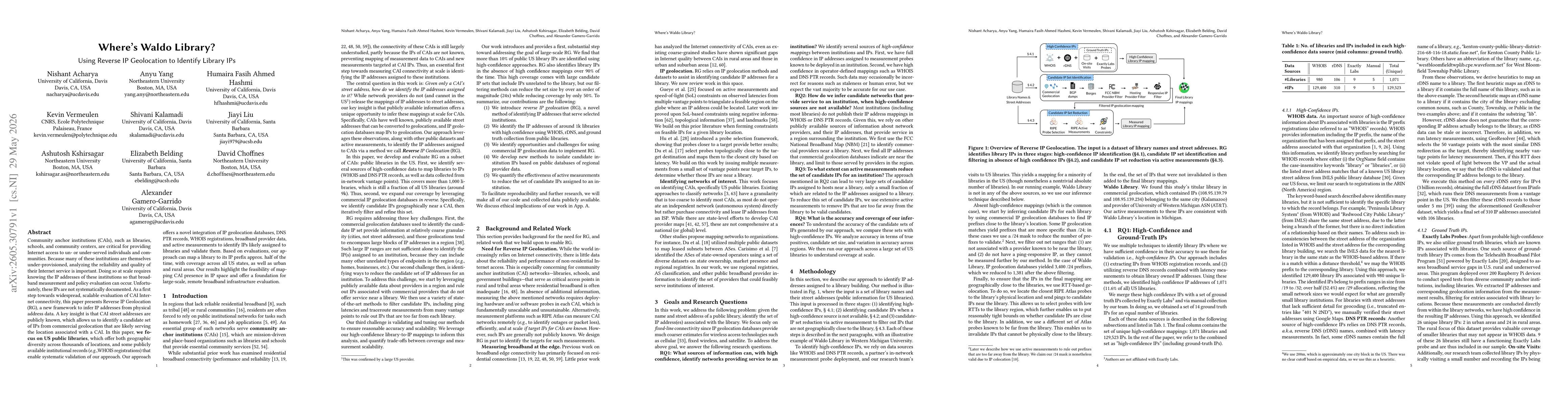
The paper develops Reverse IP Geolocation (RG), a framework that combines public address data, IP geolocation databases, DNS PTR records, WHOIS, broadband provider data, and active measurements to infer IP addresses assigned to US public libraries. It identifies high-confidence library-to-IP mappings using WHOIS and DNS data, then expands coverage by leveraging commercial geolocation databases to generate candidate IPs near each CAI location, followed by iterative filtering using latency, traceroute, and regional provider data to prune distant IPs. Validation relies on high-confidence mappings from a subset of libraries and ground-truth collection from public libraries, with scalability considerations for large-scale measurements such as RIPE Atlas campaigns.
Where's Waldo Library? Using Reverse IP Geolocation to Identify Library IPs
Publication
Metrics
Quick Answers
What methodology did the authors use?
The paper develops Reverse IP Geolocation (RG), a framework that combines public address data, IP geolocation databases, DNS PTR records, WHOIS, broadband provider data, and active measurements to infer IP addresses assigned to US public libraries. It identifies high-confidence library-to-IP mappings using WHOIS and DNS data, then expands coverage by leveraging commercial geolocation databases to generate candidate IPs near each... More in Methodology →
What are the key results?
The RG approach can map a library to its IP prefix approximately half of the time, achieving broad geographic coverage across all US states and both urban and rural areas. — High-confidence library-to-IP mappings are achievable for around 10% of public US libraries using WHOIS, DNS PTR, and ground-truth data. More in Key Results →
Why is this work significant?
Demonstrates a feasible, scalable method to map CAIs (specifically US public libraries) to IP space, enabling remote broadband infrastructure evaluation and large-scale measurement campaigns without requiring institution-level IP disclosures. This foundational step supports policy evaluation and measurement deployment at scale by linking physical CAIs to network endpoints. More in Significance →
What are the main limitations?
Coverage depends on the availability and accuracy of public datasets (WHOIS, DNS PTR, provider data) and may miss libraries with sparse public records. — Large candidate IP sets introduce noise and require substantial filtering, which may still leave some unrelated endpoints within regional IP blocks. More in Limitations →
Paper Preview
Abstract
Community anchor institutions (CAIs), such as libraries, schools, and community centers, are critical for providing Internet access to un- or under-served individuals and communities. Because many of these institutions are themselves under-provisioned, analyzing the reliability and quality of their Internet service is important. Doing so at scale requires knowing the IP addresses of these institutions so that broadband measurement and policy evaluation can occur. Unfortunately, these IPs are not systematically documented. As a first step towards widespread, scalable evaluation of CAI Internet connectivity, this paper presents Reverse IP Geolocation (RG), a new framework to infer IP addresses from physical address data. A key insight is that CAI street addresses are publicly known, which allows us to identify a candidate set of IPs from commercial geolocation that are likely serving the location associated with a CAI. In this paper, \textbf{we focus on US public libraries}, which offer both geographic diversity across thousands of locations, and some publicly available institutional records (\eg{}WHOIS registrations) that enable systematic validation of our approach. Our approach offers a novel integration of IP geolocation databases, DNS PTR records, WHOIS registrations, broadband provider data, and active measurements to identify IPs likely assigned to libraries and validate them. Based on evaluations, our approach can map a library to its IP prefix approx. half of the time, with coverage across all US states, as well as urban and rural areas. Our results highlight the feasibility of mapping CAI presence in IP space and offer a foundation for large-scale, remote broadband infrastructure evaluation.
Key Findings, in focus
Seven facets of this paper, analysed and brought into focus by AI.
Demonstrates a feasible, scalable method to map CAIs (specifically US public libraries) to IP space, enabling remote broadband infrastructure evaluation and large-scale measurement campaigns without requiring institution-level IP disclosures.
- The RG approach can map a library to its IP prefix approximately half of the time, achieving broad geographic coverage across all US states and both urban and rural areas.
- High-confidence library-to-IP mappings are achievable for around 10% of public US libraries using WHOIS, DNS PTR, and ground-truth data.
- RG can identify library IPs even in the absence of high-confidence mappings for over 90% of cases, though with larger candidate IP sets requiring filtering.
- Filtering methods reduce candidate IP sets by over 24x with only a 50% reduction in coverage, enabling scalable analysis for large CAI cohorts.
Demonstrates a feasible, scalable method to map CAIs (specifically US public libraries) to IP space, enabling remote broadband infrastructure evaluation and large-scale measurement campaigns without requiring institution-level IP disclosures. This foundational step supports policy evaluation and measurement deployment at scale by linking physical CAIs to network endpoints.
Proposes Reverse IP Geolocation (RG), a novel integration pipeline that fuses IP geolocation databases, DNS PTR data, WHOIS registrations, regional provider information, and active measurements to infer IP addresses corresponding to CAIs; provides 1) a high-confidence library-to-IP mapping approach, 2) a methodology to isolate institution-specific IPs from coarse geolocation data, 3) a framework for validating and tuning RG at scale, and 4) a pathway for leveraging commercial geolocation data in network measurement workflows.
Introduces the concept of reverse geolocating IPs to physical CAI addresses by cross-linking public address data with IP-to-location databases and active network measurements, enabling scalable identification of library IPs for remote broadband evaluation where direct IP mappings are not publicly documented.
- Coverage depends on the availability and accuracy of public datasets (WHOIS, DNS PTR, provider data) and may miss libraries with sparse public records.
- Large candidate IP sets introduce noise and require substantial filtering, which may still leave some unrelated endpoints within regional IP blocks.
- Reliance on coarse-grained geolocation (city-level) in commercial databases can hinder precise mapping to street-level IOs, potentially affecting specificity.
- Validation is primarily conducted on a subset of libraries; full scalability to all US libraries may yield varying accuracy across regions and provider ecosystems.
- Improve temporal robustness by incorporating ongoing updates to WHOIS, DNS records, and provider databases to maintain current mappings.
- Explore improved geolocation signals and alternative datasets to further reduce candidate sets without sacrificing coverage.
- Develop standardized benchmarks and open datasets to enable reproducibility and allow broader community validation of RG accuracy.
- Extend RG to additional CAI types beyond libraries (e.g., schools, community centers) and to private institutions under certain policy constraints.
Discussion 0