Wildfire Forecasting with Satellite Images and Deep Generative Model
Publication
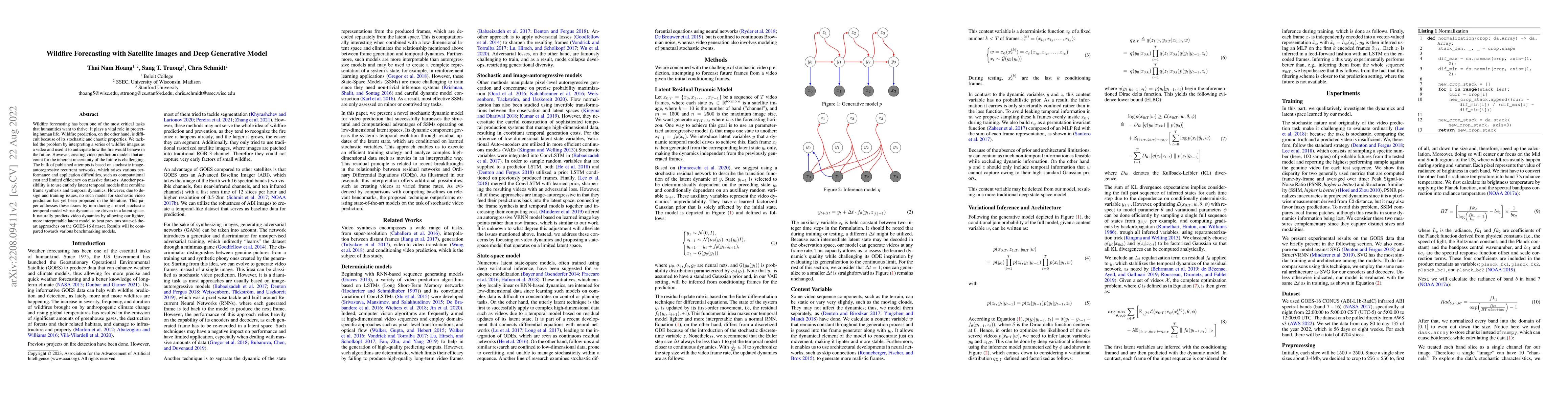
Metrics
AI Quick Summary
This paper introduces a novel stochastic temporal model driven in a latent space for wildfire forecasting using satellite images. The proposed deep generative model outperforms existing methods on the GOES-16 dataset, addressing computational costs and efficiency issues.
Paper Preview
Abstract
Wildfire forecasting has been one of the most critical tasks that humanities want to thrive. It plays a vital role in protecting human life. Wildfire prediction, on the other hand, is difficult because of its stochastic and chaotic properties. We tackled the problem by interpreting a series of wildfire images as a video and used it to anticipate how the fire would behave in the future. However, creating video prediction models that account for the inherent uncertainty of the future is challenging. The bulk of published attempts is based on stochastic image-autoregressive recurrent networks, which raises various performance and application difficulties, such as computational cost and limited efficiency on massive datasets. Another possibility is to use entirely latent temporal models that combine frame synthesis and temporal dynamics. However, due to design and training issues, no such model for stochastic video prediction has yet been proposed in the literature. This paper addresses these issues by introducing a novel stochastic temporal model whose dynamics are driven in a latent space. It naturally predicts video dynamics by allowing our lighter, more interpretable latent model to beat previous state-of-the-art approaches on the GOES-16 dataset. Results will be compared towards various benchmarking models.
AI Key Findings
Get AI-generated insights about this paper's methodology, results, significance, and more — seven facets brought into focus.
Impact
Paper Details
Authors
PDF Preview
Key Terms
Citation Network
Current paper (gray), citations (green), references (blue)
Display is limited for performance on very large graphs.
Discussion 0