A hierarchical multi‑agent framework (Supervisor‑Worker) that uses data‑type introspection for routing, sandboxed deterministic code execution, self‑correction via execution feedback, cross‑model error escalation, and a visual quality‑control loop.
A Hierarchical Multi-Agent System for Autonomous Discovery in Geoscientific Data Archives
Publication
Metrics
Quick Answers
What methodology did the authors use?
A hierarchical multi‑agent framework (Supervisor‑Worker) that uses data‑type introspection for routing, sandboxed deterministic code execution, self‑correction via execution feedback, cross‑model error escalation, and a visual quality‑control loop. More in Methodology →
What are the key results?
The system autonomously completed complex, multi‑step workflows in four diverse geoscience scenarios with minimal human intervention. — It produced statistically significant analyses (e.g., Spearman ρ = −0.466, bias +0.35 °C, RMSE 1.09 °C) while maintaining reproducibility through deterministic execution. More in Key Results →
Why is this work significant?
By automating data retrieval, analysis, and validation in large geoscience archives, the framework unlocks underutilized data, accelerates discovery, and promotes reproducible research. More in Significance →
What are the main limitations?
Reliance on external APIs and data availability limits applicability when services are unavailable. — Current agent specialization covers only a subset of data modalities, requiring manual extension for new formats. More in Limitations →
Abstract
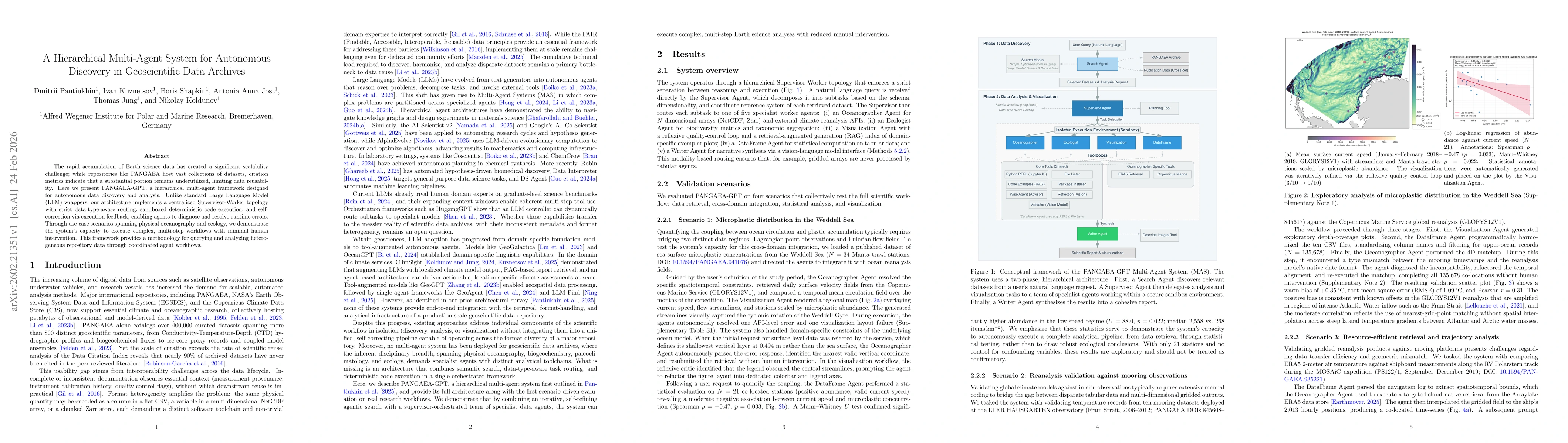
The rapid accumulation of Earth science data has created a significant scalability challenge; while repositories like PANGAEA host vast collections of datasets, citation metrics indicate that a substantial portion remains underutilized, limiting data reusability. Here we present PANGAEA-GPT, a hierarchical multi-agent framework designed for autonomous data discovery and analysis. Unlike standard Large Language Model (LLM) wrappers, our architecture implements a centralized Supervisor-Worker topology with strict data-type-aware routing, sandboxed deterministic code execution, and self-correction via execution feedback, enabling agents to diagnose and resolve runtime errors. Through use-case scenarios spanning physical oceanography and ecology, we demonstrate the system's capacity to execute complex, multi-step workflows with minimal human intervention. This framework provides a methodology for querying and analyzing heterogeneous repository data through coordinated agent workflows.
Key Findings, in focus
Seven facets of this paper, analysed and brought into focus by AI.
By automating data retrieval, analysis, and validation in large geoscience archives, the framework unlocks underutilized data, accelerates discovery, and promotes reproducible research.
- The system autonomously completed complex, multi‑step workflows in four diverse geoscience scenarios with minimal human intervention.
- It produced statistically significant analyses (e.g., Spearman ρ = −0.466, bias +0.35 °C, RMSE 1.09 °C) while maintaining reproducibility through deterministic execution.
- Self‑correction and cross‑model fallback reduced runtime failures by roughly 80 % compared to conventional LLM wrappers.
By automating data retrieval, analysis, and validation in large geoscience archives, the framework unlocks underutilized data, accelerates discovery, and promotes reproducible research.
A hierarchical, data‑type‑aware multi‑agent system with sandboxed deterministic execution, self‑correction, cross‑model error escalation, and visual quality‑control, enabling reproducible, error‑resilient geoscience workflows.
First integration of hierarchical agent orchestration with deterministic sandboxed execution and cross‑model fallback for autonomous, reproducible discovery in geoscience data archives.
- Reliance on external APIs and data availability limits applicability when services are unavailable.
- Current agent specialization covers only a subset of data modalities, requiring manual extension for new formats.
- Expand the agent library to support additional data types such as satellite imagery and high‑frequency time series.
- Incorporate adaptive, learning‑based routing and dynamic thresholding to improve robustness across evolving datasets.
Discussion 0