ArxivLens

Publication

Published: Apr 09, 2025
Categories: cs.RO

Metrics

Source: ArXiv

AI Quick Summary

A new framework for relocalization in subterranean environments uses point cloud registration with Intrinsic Shape Signatures and Iterative Closest Point to improve accuracy even in challenging conditions.

Quick Answers

What is "A Pointcloud Registration Framework for Relocalization in Subterranean Environments" about?

A new framework for relocalization in subterranean environments uses point cloud registration with Intrinsic Shape Signatures and Iterative Closest Point to improve accuracy even in challenging conditions.

What methodology did the authors use?

The research proposes a relocalization framework for autonomous robots in subterranean environments using point cloud registration, employing Intrinsic Shape Signatures (ISS) for feature point selection, Fast Point Feature Histogram (FPFH) for descriptor computation, and a two-stage transformation refinement using Normal Distribution Transform (NDT) and Iterative Closest Point (ICP) algorithms. More in Methodology →

What are the key results?

The proposed framework enhances registration accuracy in challenging conditions such as dust interference and significant initial transformations. — Experiments in simulated and real-world mine datasets demonstrated the framework's potential for improving relocalization. More in Key Results →

Why is this work significant?

This research is important for developing autonomous robots capable of navigating and performing tasks in subterranean environments, where GPS is unavailable, and traditional localization methods fail due to poor lighting, irregular surfaces, and dust. More in Significance →

What are the main limitations?

The framework's performance may not always yield the lowest RMSE or highest inlier percentage. — The study was limited to specific simulated and real-world mine environments, and further testing in diverse subterranean conditions is needed. More in Limitations →

Paper Preview

Abstract

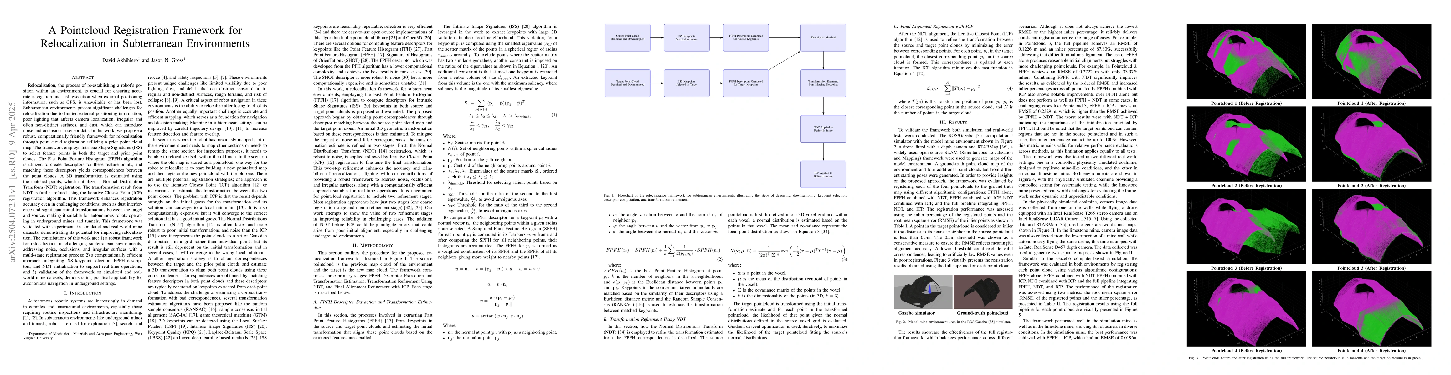
Relocalization, the process of re-establishing a robot's position within an environment, is crucial for ensuring accurate navigation and task execution when external positioning information, such as GPS, is unavailable or has been lost. Subterranean environments present significant challenges for relocalization due to limited external positioning information, poor lighting that affects camera localization, irregular and often non-distinct surfaces, and dust, which can introduce noise and occlusion in sensor data. In this work, we propose a robust, computationally friendly framework for relocalization through point cloud registration utilizing a prior point cloud map. The framework employs Intrinsic Shape Signatures (ISS) to select feature points in both the target and prior point clouds. The Fast Point Feature Histogram (FPFH) algorithm is utilized to create descriptors for these feature points, and matching these descriptors yields correspondences between the point clouds. A 3D transformation is estimated using the matched points, which initializes a Normal Distribution Transform (NDT) registration. The transformation result from NDT is further refined using the Iterative Closest Point (ICP) registration algorithm. This framework enhances registration accuracy even in challenging conditions, such as dust interference and significant initial transformations between the target and source, making it suitable for autonomous robots operating in underground mines and tunnels. This framework was validated with experiments in simulated and real-world mine datasets, demonstrating its potential for improving relocalization.

Key Findings, in focus

Seven facets of this paper, analysed and brought into focus by AI.

AI-generated · verify against source Generated Jun 10, 2025
In focus · one-line synthesis

This research is important for developing autonomous robots capable of navigating and performing tasks in subterranean environments, where GPS is unavailable, and traditional localization methods fail due to poor lighting, irregular surfaces, and dust.

01
MethodologyHow they did it

The research proposes a relocalization framework for autonomous robots in subterranean environments using point cloud registration, employing Intrinsic Shape Signatures (ISS) for feature point selection, Fast Point Feature Histogram (FPFH) for descriptor computation, and a two-stage transformation refinement using Normal Distribution Transform (NDT) and Iterative Closest Point (ICP) algorithms.

02
ResultsWhat they found
  • The proposed framework enhances registration accuracy in challenging conditions such as dust interference and significant initial transformations.
  • Experiments in simulated and real-world mine datasets demonstrated the framework's potential for improving relocalization.
  • The full registration pipeline (FPFH+NDT+ICP) consistently delivered reliable registration across various scenarios, even if it didn't always achieve the lowest RMSE or highest inlier percentage.
  • Simpler configurations like FPFH+ICP or FPFH+NDT performed sufficiently well, while the full pipeline maintained consistent performance in diverse conditions.
  • The framework decreased RMSE to roughly 0.12m with nearly 88% inliers in challenging cases, outperforming FPFH alone.
03
SignificanceWhy it matters

This research is important for developing autonomous robots capable of navigating and performing tasks in subterranean environments, where GPS is unavailable, and traditional localization methods fail due to poor lighting, irregular surfaces, and dust.

04
Technical ContributionsWhat's new technically

The main technical contribution is a robust, computationally friendly point cloud registration framework for relocalization in subterranean environments, combining ISS, FPFH, NDT, and ICP algorithms.

05
NoveltyWhat sets it apart

This work is novel in its comprehensive approach to addressing the challenges of relocalization in subterranean environments by integrating multiple algorithms into a single, reliable framework, which was validated through simulations and real-world experiments.

06
LimitationsWhat to be cautious about
  • The framework's performance may not always yield the lowest RMSE or highest inlier percentage.
  • The study was limited to specific simulated and real-world mine environments, and further testing in diverse subterranean conditions is needed.
07
Future WorkWhere it goes next
  • Expand dataset collection from various subterranean environments and conditions (e.g., dust, moisture) to refine the approach.
  • Optimize algorithms for feature extraction, point cloud registration, and transformation estimation to improve performance and reliability.
  • Integrate the framework with autonomous robotic systems to assess its performance in real-time navigation tasks and decision-making processes in underground settings.

Impact

36
References

Paper Details

Paper ID: 2504.07231
Categories:
cs.RO

How to Cite This Paper

Reference manager: RIS EndNote

Citation Network

Current paper (gray), citations (green), references (blue)

Display is limited for performance on very large graphs.

Current Paper
Citations
References
Click to view


Discussion 0

This website uses cookies to ensure you get the best experience. Learn more