The research employs a hybrid approach combining global path planning algorithms with kinodynamic constraints, utilizing a modified A* algorithm integrated with Voronoi diagrams for obstacle avoidance and terrain adaptability.
Publication
Metrics
Quick Answers
What methodology did the authors use?
The research employs a hybrid approach combining global path planning algorithms with kinodynamic constraints, utilizing a modified A* algorithm integrated with Voronoi diagrams for obstacle avoidance and terrain adaptability. More in Methodology →
What are the key results?
Achieved efficient long-distance off-road navigation with reduced computational overhead — Demonstrated improved path smoothness and dynamic feasibility through kinodynamic optimization More in Key Results →
Why is this work significant?
This work advances autonomous vehicle navigation in challenging environments by providing a robust framework that balances computational efficiency with path quality, enabling practical deployment in real-world off-road scenarios. More in Significance →
What are the main limitations?
Requires detailed terrain information which may not always be available — Computational complexity increases with large-scale environments More in Limitations →
Abstract
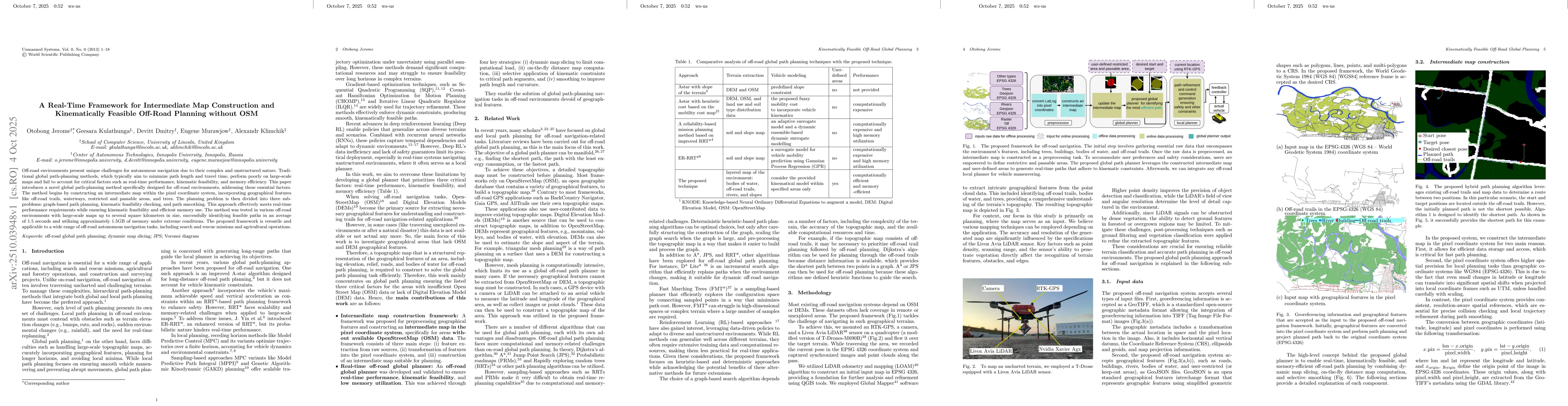
Off-road environments present unique challenges for autonomous navigation due to their complex and unstructured nature. Traditional global path-planning methods, which typically aim to minimize path length and travel time, perform poorly on large-scale maps and fail to account for critical factors such as real-time performance, kinematic feasibility, and memory efficiency. This paper introduces a novel global path-planning method specifically designed for off-road environments, addressing these essential factors. The method begins by constructing an intermediate map within the pixel coordinate system, incorporating geographical features like off-road trails, waterways, restricted and passable areas, and trees. The planning problem is then divided into three sub-problems: graph-based path planning, kinematic feasibility checking, and path smoothing. This approach effectively meets real-time performance requirements while ensuring kinematic feasibility and efficient memory use. The method was tested in various off-road environments with large-scale maps up to several square kilometers in size, successfully identifying feasible paths in an average of 1.5 seconds and utilizing approximately 1.5GB of memory under extreme conditions. The proposed framework is versatile and applicable to a wide range of off-road autonomous navigation tasks, including search and rescue missions and agricultural operations.
Key Findings, in focus
Seven facets of this paper, analysed and brought into focus by AI.
This work advances autonomous vehicle navigation in challenging environments by providing a robust framework that balances computational efficiency with path quality, enabling practical deployment in real-world off-road scenarios.
- Achieved efficient long-distance off-road navigation with reduced computational overhead
- Demonstrated improved path smoothness and dynamic feasibility through kinodynamic optimization
- Validated the method's effectiveness in complex terrains with real-world experimental data
This work advances autonomous vehicle navigation in challenging environments by providing a robust framework that balances computational efficiency with path quality, enabling practical deployment in real-world off-road scenarios.
Proposed a novel kinodynamic global planning framework that integrates Voronoi diagram-based obstacle avoidance with modified A* search, enabling dynamically feasible paths in complex off-road environments.
The integration of Voron,oi diagrams with kinodynamic constraints in a global planning framework represents a significant departure from traditional methods, offering both computational efficiency and path quality improvements.
- Requires detailed terrain information which may not always be available
- Computational complexity increases with large-scale environments
- Integration with real-time sensor data for adaptive path planning
- Exploration of machine learning techniques for terrain prediction
- Development of energy-efficient path planning algorithms
Discussion 0