Background
The field of large scale 3D earth modeling has traditionally relied on dense photogrammetry and LiDAR to recover geometry and textures. These methods deliver high fidelity but are stymied by data collection costs, processing latency, and limited geographic coverage. Recent advances in 3D generative modeling have shown promise at object scales, yet transferring these strengths to planetary extents remains non trivial due to scale, data heterogeneity, and the need for consistent conditioning signals. ABot-Earth 0.5 positions 3D Gaussian splatting as a native representation for large scale, photorealistic outdoors, enabling continuous LOD and compact geometry representations suitable for streaming.
Problem / Research Question
The work asks whether it is possible to synthesize globally coherent, interactive 3D outdoor environments directly from satellite imagery without requiring precise capture angles or multi-view overlaps, while maintaining fidelity to real world urban and natural scenes. It also seeks to address how to scale a generative 3D model to Earth scale, how to manage data heterogeneity across sources, and how to render trillions of primitives in a way that supports real time exploration on map engines with consistent LOD.
Innovation / Contribution
The ABot-Earth 0.5 system delivers several core innovations. First, a native 3DGS generative pipeline trained on diverse real world reconstructions learns to produce both geometry and textures that align with real world objects such as facades, foliage, roads, and water. Second, conditioning on satellite imagery is made robust via a cross domain adaptation strategy using a Vision Language Model based harness that tunes conditioning to the particular satellite input. Third, the system achieves Earth scale with a tile based production workflow, aligning each tile to a common ENU coordinate frame with precise georeferencing, and generating a multi level of detail hierarchy directly from the generator. Fourth, a two stage deployment strategy separates global production of trillions of Gaussian primitives from scalable post processing and rendering, enabling streaming into a map engine with a tile based scheduling system. Finally, a hybrid generation approach demonstrates the practical extensibility of the platform by compositing high fidelity landmark reconstructions into the generative backdrop.
Methodology / Approach
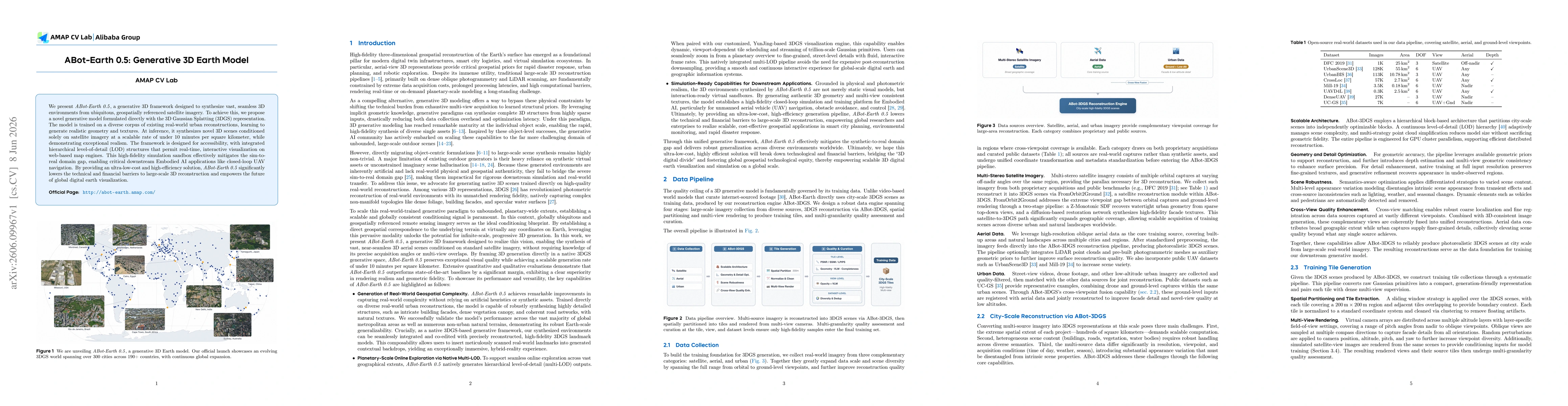
The pipeline begins with data collection across satellite, aerial, and urban imagery, feeding ABot-3DGS reconstruction which outputs city scale 3DGS tiles. A multi granularity quality assessment ensures only high fidelity tiles are retained, balancing spatial diversity and deduplicating semantically near duplicates. The model is trained on real world urban reconstructions and optionally uses LiDAR priors to boost surface fidelity. At inference, satellite imagery is mosaicked to a consistent ground sampling distance, then a 1.6 km by 1.6 km block is processed in a single inference pass on A100 GPUs, producing hundreds of billions of Gaussians per tile. The produced block is transformed into an ENU local tangent plane, re assigned to a standard map tile hierarchy, and integrated with a map engine via a 3D Tiles compatible tileset. A three tier LOD chain is generated, with zoom levels 17 to 19 produced natively and lower levels generated via an analytic decimation of Gaussian parameters, enabling seamless streaming and web based visualization.
A central challenge is cross domain conditioning, which ABot-Earth 0.5 addresses with a VLM based harness that dynamically adapts conditioning signals during inference. The result is robust 3D content conditioned on satellite images from diverse sources and capture conditions. The system also supports a hybrid workflow where high fidelity landmark reconstructions are integrated with the generative backdrop to deliver a mixed reality experience.
Experiments / Evaluation
The paper reports a substantial quantitative evaluation. The ABot-Earth 0.5 model achieves a state of the art FID score of 16.1 on a ground truth distribution derived from renderings of authentic 3DGS reconstructions, indicating strong photometric fidelity in the synthetic outputs. Comparative analyses against Google Earth and Marble show that while the system can rival traditional methods in many regions, Google Earth still holds advantages in geometric precision and texture fidelity in well surveyed areas, highlighting the practical complementarity between generative earth models and traditional reconstruction pipelines.
Human studies indicate that observers rate geometric accuracy and texture fidelity favorably for ABot-Earth 0.5, with lighting and color harmony contributing significantly to perceived realism. The authors emphasize that the generative model excels in capturing complex non manifold structures like foliage and water, and that the system can produce coherent road networks and facades across large extents. In terms of performance, the inference scales to 1 km2 chunks in under 10 minutes on satellite inputs, and a 1,000 GPU cluster can process roughly 312 500 tiles in under 10 days, enabling practical Earth scale production timelines.
Key Results
Beyond fidelity metrics, the system demonstrates broad geographic coverage with a world spanning over 300 cities across 190 plus countries, continuously expanding. The generated content is compatible with real world landmarks via a hybrid generation approach, enabling immersive experiences where synthetic surroundings are seamlessly blended with scanned reconstructions. The multi-LOD approach and the integration with the Amap Yunjing engine enable real time streaming and interactive exploration over trillion scale Gaussian primitives while maintaining visual coherence across tile boundaries.
Practical Applications
ABot-Earth 0.5 enables rapid on demand generation of 3D ambient scenes for digital twins, urban planning, disaster response simulations, and robotics training. By providing native 3DGS assets conditioned solely on satellite imagery, it lowers the cost and barriers to building global 3D map services and can underpin a range of simulation based workflows, from city planning to autonomous drone navigation. The composability with real landmarks also supports hybrid workflows where high fidelity detail can be added where most impactful, enabling targeted quality improvements without abandoning the scalability of the generative backdrop.
Limitations & Considerations
Despite strong performance, the work acknowledges room for improvement in fully seamless cross-block inference, a challenge left for future work. The reliance on satellite input quality implies a domain gap across sensors and atmospheric conditions, although the VLM harness mitigates this to a degree. The pipeline requires substantial GPU clusters and robust data management for trillions of primitives, which raises deployment and maintenance considerations for real world operators. Finally, the evaluation focuses on static content, and extending the framework to dynamic digital twins with changing landscapes remains an open area for exploration.
Discussion 0