ArxivLens
ArXiv cs.IR

An Open-Source Tool for Reproducible Freeway Network Extraction from OpenStreetMap

Drew Miller, Cathy Wu

2606.31857 Published Jun 30, 2026
View PDF

Publication

Published: Jun 30, 2026
Categories: cs.IR

Metrics

Source: ArXiv

Quick Answers

What methodology did the authors use?

The study presents an open-source tool that automates freeway network extraction from OpenStreetMap by constructing a directed roadway graph, isolating the desired mainline corridor, clipping to endpoints, computing reference stationing, processing lane configurations, and detecting ramp connections; outputs include lanes.csv and ramps.csv along with HTML/KML validation artifacts, enabling an extract-then-validate workflow with corridor-specific querying and visual validation. More in Methodology →

What are the key results?

Two prototype corridors demonstrated that the extract-first-then-validate approach reduces analyst effort to roughly one-third of manual ramp encoding. — Orange County deployment covered 359.6 miles with average processing and validation time of about 41 seconds per mile. More in Key Results →

Why is this work significant?

The tool offers a scalable, reproducible foundation for freeway network preparation by integrating automated extraction with structured validation artifacts and a user-friendly corridor-focused workflow, addressing prior limitations in freeway-specific OSM workflows. More in Significance →

What are the main limitations?

Manual validation against aerial imagery and OSN remains a bottleneck for large deployments. — Geographic generalizability may be limited in rural or less-mapped regions where OSM contributions are sparser. More in Limitations →

Paper Preview

Abstract

Freeway simulation is often difficult to deploy at scale not only because of model formulation, but because preparing road network inputs remains a manual, corridor-specific, and difficult-to-reproduce task. This paper presents an open-source tool that extracts freeway networks from OpenStreetMap (OSM) and converts them into a compact, station-referenced representation suitable for downstream freeway simulation. Unlike existing tools that primarily support arterial or general network conversion tasks, the proposed workflow is designed around the specific requirements of freeway traffic studies. The tool supports not only OSM data cleaning and conversion, but also the broader workflow required in practice: corridor-specific querying, visual inspection of extracted segments, extraction validation against OSM, and source-data validation against aerial imagery. A locally hosted frontend allows users to define corridor-specific queries, select endpoints visually, and inspect extracted segments. The extraction logic is designed to address several recurring challenges in freeway OSM data, including inconsistent route references, ambiguous path selection through interchanges, managed-lane interference, incomplete corridor capture from naive bounding-box queries, and inconsistent ramp classifications. The workflow was first tested on two prototype corridors, where the extract-first-then-validate approach proposed here required roughly one-third the analyst effort of manual ramp encoding from scratch. It was then deployed across 359.6 miles of freeway in Orange County, California, with total processing and validation averaging about 41 seconds per mile. This deployment also suggests that, in a well-mapped region, OSM is sufficiently accurate for many freeway traffic studies. Overall, the tool provides a more scalable and reproducible foundation for freeway network preparation.
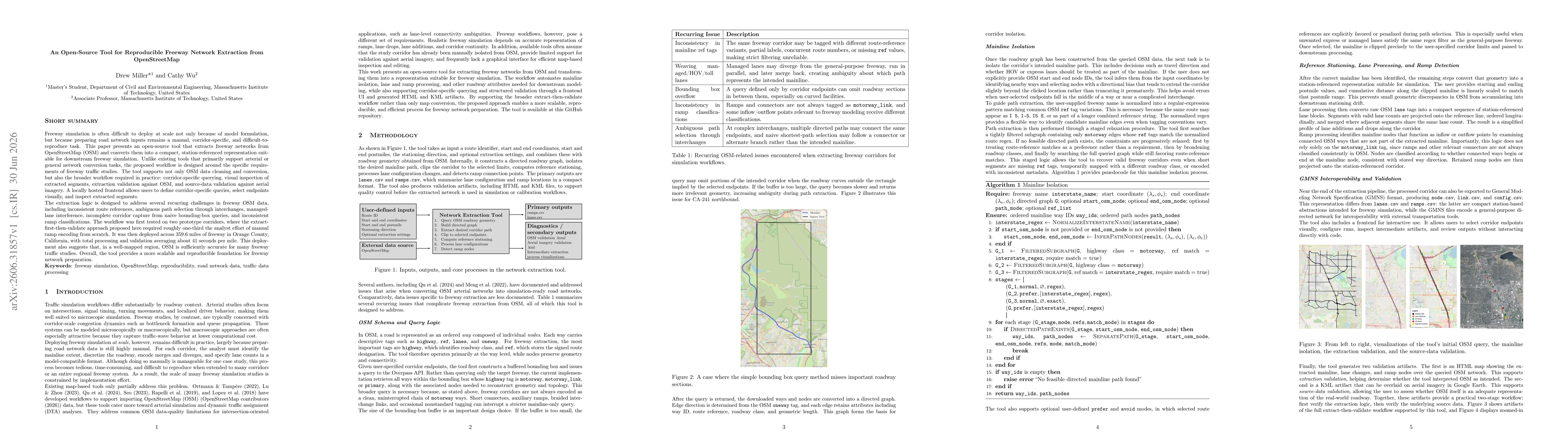
Key Findings, in focus

Seven facets of this paper, analysed and brought into focus by AI.

AI-generated · verify against source Generated Jul 02, 2026
In focus · one-line synthesis

The tool offers a scalable, reproducible foundation for freeway network preparation by integrating automated extraction with structured validation artifacts and a user-friendly corridor-focused workflow, addressing prior limitations in freeway-specific OSM workflows.

01
MethodologyHow they did it

The study presents an open-source tool that automates freeway network extraction from OpenStreetMap by constructing a directed roadway graph, isolating the desired mainline corridor, clipping to endpoints, computing reference stationing, processing lane configurations, and detecting ramp connections; outputs include lanes.csv and ramps.csv along with HTML/KML validation artifacts, enabling an extract-then-validate workflow with corridor-specific querying and visual validation.

02
ResultsWhat they found
  • Two prototype corridors demonstrated that the extract-first-then-validate approach reduces analyst effort to roughly one-third of manual ramp encoding.
  • Orange County deployment covered 359.6 miles with average processing and validation time of about 41 seconds per mile.
  • OSM data quality in a well-mapped region appeared sufficient for many freeway traffic studies, enabling scalable network preparation.
03
SignificanceWhy it matters

The tool offers a scalable, reproducible foundation for freeway network preparation by integrating automated extraction with structured validation artifacts and a user-friendly corridor-focused workflow, addressing prior limitations in freeway-specific OSM workflows.

04
Technical ContributionsWhat's new technically

An open-source, corridor-aware freeway extraction tool that queries OSM with a buffered bounding box to recover mainline paths, constructs a directed graph, clips corridors, computes reference stationing, processes lane/ramp configurations, and outputs structured artifacts plus validation visualizations.

05
NoveltyWhat sets it apart

Unlike arterial-focused tools, this work explicitly targets freeway-specific topology, including ramp connections, lane configurations, and corridor continuity, enabling extract-then-validate workflows with reproducible, station-referenced representations for freeway simulation.

06
LimitationsWhat to be cautious about
  • Manual validation against aerial imagery and OSN remains a bottleneck for large deployments.
  • Geographic generalizability may be limited in rural or less-mapped regions where OSM contributions are sparser.
  • Validation relies on human-in-the-loop review, potentially constraining fully automated pipelines.
07
Future WorkWhere it goes next
  • Automate validation through vision-language agents to compare extracted features against imagery and flag discrepancies.
  • Extend evaluation to rural and other regions to assess transferability and generalizability of the workflow.

Paper Details

Paper ID: 2606.31857
Categories:
cs.IR

How to Cite This Paper

Reference manager: RIS EndNote


Discussion 0

This website uses cookies to ensure you get the best experience. Learn more