AI Quick Summary
A novel method of coverage path planning for autonomous navigation of quadrupeds is proposed, utilizing a finite state machine to optimize path planning while scanning an unstructured environment.
Quick Answers
What is "Autonomous Navigation Of Quadrupeds Using Coverage Path Planning" about?
A novel method of coverage path planning for autonomous navigation of quadrupeds is proposed, utilizing a finite state machine to optimize path planning while scanning an unstructured environment.
What methodology did the authors use?
This paper proposes a novel coverage path planning method for quadruped robots using the morphological skeleton of a 2D navigation map generated via SLAM. It employs a finite state machine to manage navigation and scanning modes. More in Methodology →
What are the key results?
The map reader and path planner can process maps of varying sizes quickly (2.52 ms/pixel and 1.7 ms/pixel, respectively). — The robot reached 86.5% of all waypoints over five trials. More in Key Results →
Why is this work significant?
This research contributes to autonomous navigation for quadruped robots in unstructured environments, which is crucial for applications like surveillance, inspection, and search and rescue. More in Significance →
What are the main limitations?
The method suffers from drift in the 2D navigation map. — Does not account for obstacles inside large free spaces. More in Limitations →
Paper Preview
Abstract
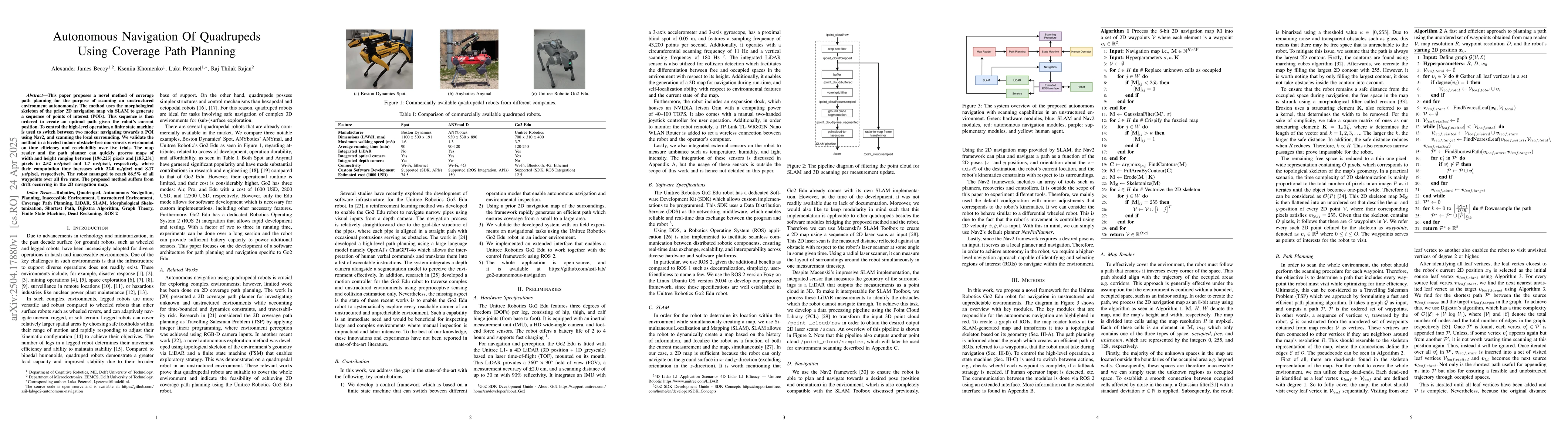
This paper proposes a novel method of coverage path planning for the purpose of scanning an unstructured environment autonomously. The method uses the morphological skeleton of the prior 2D navigation map via SLAM to generate a sequence of points of interest (POIs). This sequence is then ordered to create an optimal path given the robot's current position. To control the high-level operation, a finite state machine is used to switch between two modes: navigating towards a POI using Nav2, and scanning the local surrounding. We validate the method in a leveled indoor obstacle-free non-convex environment on time efficiency and reachability over five trials. The map reader and the path planner can quickly process maps of width and height ranging between [196,225] pixels and [185,231] pixels in 2.52 ms/pixel and 1.7 ms/pixel, respectively, where their computation time increases with 22.0 ns/pixel and 8.17 $\mu$s/pixel, respectively. The robot managed to reach 86.5\% of all waypoints over all five runs. The proposed method suffers from drift occurring in the 2D navigation map.
AI Key Findings
Generated Jun 09, 2025
Methodology — What approach did the authors take?
This paper proposes a novel coverage path planning method for quadruped robots using the morphological skeleton of a 2D navigation map generated via SLAM. It employs a finite state machine to manage navigation and scanning modes.
Key Results — What are the main findings?
- The map reader and path planner can process maps of varying sizes quickly (2.52 ms/pixel and 1.7 ms/pixel, respectively).
- The robot reached 86.5% of all waypoints over five trials.
- Computational time increases by 22.0 ns/pixel for map reader and 8.17 µs/pixel for path planner.
Significance — Why does this research matter?
This research contributes to autonomous navigation for quadruped robots in unstructured environments, which is crucial for applications like surveillance, inspection, and search and rescue.
Technical Contribution — What is the technical contribution?
The development of an open-source framework using ROS2 that enables a Unitree Robotics Go2 quadruped to autonomously navigate and cover an environment using a prior 2D navigation map.
Novelty — What is new about this work?
This work stands out by focusing on autonomous navigation using coverage path planning for quadruped robots, an area with limited existing research.
Limitations — What are the limitations of this study?
- The method suffers from drift in the 2D navigation map.
- Does not account for obstacles inside large free spaces.
Future Work — What did the authors propose for future work?
- Investigate the use of absolute sensors like GPS and Ultra-wideband anchors to mitigate map drift.
- Expand the method to 3D environments for real-time autonomous exploration in unknown terrains.
Paper Details
How to Cite This Paper
@article{becoy2025autonomous,
  title         = {Autonomous Navigation Of Quadrupeds Using Coverage Path Planning},
  author        = {Becoy, Alexander James and Khomenko, Kseniia and Peternel, Luka and others},
  year          = {2025},
  eprint        = {2504.17880},
  archivePrefix = {arXiv},
  primaryClass  = {cs.RO},
}Becoy, A., Khomenko, K., Peternel, L., & Rajan, R. (2025). Autonomous Navigation Of Quadrupeds Using Coverage Path Planning. arXiv. https://arxiv.org/abs/2504.17880Becoy, Alexander James, et al. "Autonomous Navigation Of Quadrupeds Using Coverage Path Planning." arXiv, 2025, arxiv.org/abs/2504.17880.PDF Preview
Citation Network
Current paper (gray), citations (green), references (blue)
Display is limited for performance on very large graphs.
Similar Papers
Found 4 papersAutonomous Vehicle Navigation with LIDAR using Path Planning
Sumukh B, Praveen L Uppunda, Rahul M K et al.
Contact-aware Path Planning for Autonomous Neuroendovascular Navigation
Aabha Tamhankar, Ron Alterovitz, Ajit S. Puri et al.
Radio-Coverage-Aware Path Planning for Cooperative Autonomous Vehicles
Giuseppe Baruffa, Luca Rugini, Francesco Binucci et al.
No citations found for this paper.
Comments (0)