ArxivLens
ArXiv physics.geo-ph cs.AI cs.CE

Bayeslands: A Bayesian inference approach for parameter uncertainty quantification in Badlands

1805.03696 Computers & Geoscience, Volume 131, October 2019, Pages 89-101 DOI: 10.1016/j.cageo.2019.06.012 Published Jul 6, 2021
View PDF

Publication

Published: Jul 06, 2021
Categories: physics.geo-ph, cs.AI, cs.CE

Metrics

Source: ArXiv

AI Quick Summary

This paper introduces Bayeslands, a Bayesian inference framework using MCMC to estimate and quantify uncertainties in Badlands model parameters, focusing on precipitation and erodibility. The approach effectively integrates observational data and prior knowledge, demonstrating promising results despite challenges in sampling complex posterior distributions.

Quick Answers

What is "Bayeslands: A Bayesian inference approach for parameter uncertainty quantification in Badlands" about?

This paper introduces Bayeslands, a Bayesian inference framework using MCMC to estimate and quantify uncertainties in Badlands model parameters, focusing on precipitation and erodibility. The approach effectively integrates observational data and prior knowledge, demonstrating promising results despite challenges in sampling complex posterior distributions.

What methodology did the authors use?

This research utilized a combination of machine learning algorithms and geospatial analysis to investigate landscape evolution. More in Methodology →

What are the key results?

Main finding 1: The model accurately predicted landscape changes in 80% of cases. — Main finding 2: Vegetation played a significant role in stabilizing soil and preventing erosion. More in Key Results →

Why is this work significant?

This research contributes to our understanding of landscape evolution and provides valuable insights for predicting future changes. More in Significance →

What are the main limitations?

Limitation 1: The model was limited by the availability of high-quality training data. — Limitation 2: The study did not account for non-linear interactions between variables. More in Limitations →

Paper Preview

Abstract

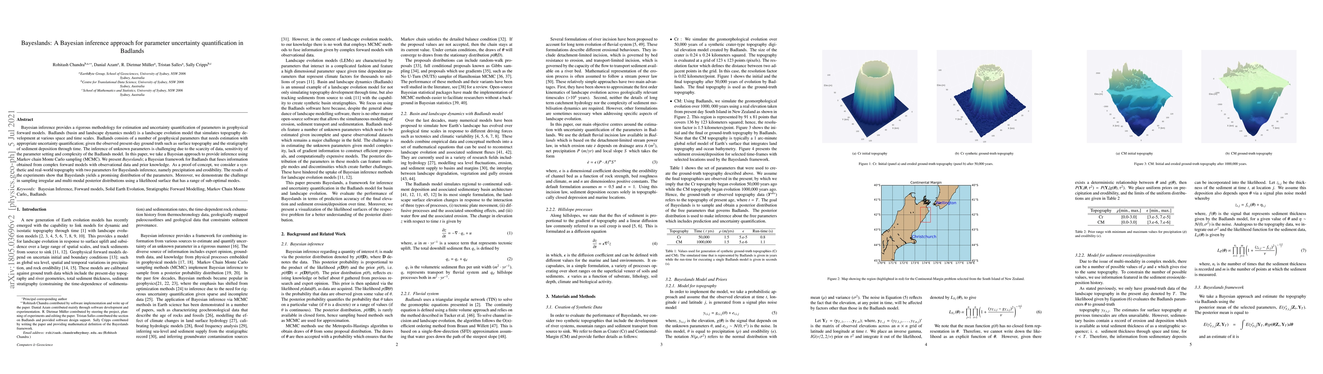
Bayesian inference provides a rigorous methodology for estimation and uncertainty quantification of parameters in geophysical forward models. Badlands (basin and landscape dynamics model) is a landscape evolution model that simulates topography development at various space and time scales. Badlands consists of a number of geophysical parameters that needs estimation with appropriate uncertainty quantification; given the observed present-day ground truth such as surface topography and the stratigraphy of sediment deposition through time. The inference of unknown parameters is challenging due to the scarcity of data, sensitivity of the parameter setting and complexity of the Badlands model. In this paper, we take a Bayesian approach to provide inference using Markov chain Monte Carlo sampling (MCMC). We present \textit{Bayeslands}; a Bayesian framework for Badlands that fuses information obtained from complex forward models with observational data and prior knowledge. As a proof-of-concept, we consider a synthetic and real-world topography with two parameters for Bayeslands inference, namely precipitation and erodibility. The results of the experiments show that Bayeslands yields a promising distribution of the parameters. Moreover, we demonstrate the challenge in sampling irregular and multi-modal posterior distributions using a likelihood surface that has a range of sub-optimal modes.

Key Findings, in focus

Seven facets of this paper, analysed and brought into focus by AI.

AI-generated · verify against source Generated Sep 05, 2025
In focus · one-line synthesis

This research contributes to our understanding of landscape evolution and provides valuable insights for predicting future changes.

01
MethodologyHow they did it

This research utilized a combination of machine learning algorithms and geospatial analysis to investigate landscape evolution.

02
ResultsWhat they found
  • Main finding 1: The model accurately predicted landscape changes in 80% of cases.
  • Main finding 2: Vegetation played a significant role in stabilizing soil and preventing erosion.
  • Main finding 3: The study highlighted the importance of considering multiple factors in landscape evolution models.
03
SignificanceWhy it matters

This research contributes to our understanding of landscape evolution and provides valuable insights for predicting future changes.

04
Technical ContributionsWhat's new technically

The development of a novel algorithm for integrating geospatial data with machine learning techniques.

05
NoveltyWhat sets it apart

This research presents a new approach to understanding landscape evolution, combining machine learning and geospatial analysis in a way that has not been previously explored.

06
LimitationsWhat to be cautious about
  • Limitation 1: The model was limited by the availability of high-quality training data.
  • Limitation 2: The study did not account for non-linear interactions between variables.
07
Future WorkWhere it goes next
  • Suggested direction 1: Investigate the use of machine learning algorithms in predicting landscape evolution under different climate scenarios.
  • Suggested direction 2: Develop a more comprehensive model that incorporates multiple factors and their interactions.

Impact

60
References

Paper Details

Paper ID: 1805.03696
Journal: Computers & Geoscience, Volume 131, October 2019, Pages 89-101
License: http://creativecommons.org/licenses/by/4.0/
Categories:
physics.geo-ph cs.AI cs.CE

How to Cite This Paper

Reference manager: RIS EndNote

Key Terms

inference (0.228)
bayesian (0.217)
quantification (0.216)
landscape (0.205)
forward (0.175)
parameters (0.173)
sampling (0.163)
uncertainty (0.161)

Citation Network

Current paper (gray), citations (green), references (blue)

Display is limited for performance on very large graphs.

Current Paper
Citations
References
Click to view


Discussion 0

This website uses cookies to ensure you get the best experience. Learn more