The research proposes an Emergency Landing (EL) system for safe UAV operations in urban environments, using a runtime monitoring architecture and semantic segmentation for landing zone selection. It adapts M1 requirements from SORA for active-M1 mitigation techniques like EL.
Publication
Metrics
AI Quick Summary
This paper investigates the Emergency Landing (EL) concept for certifying safe urban UAV operations, addressing the lack of applicable mitigation techniques in current standards. An EL implementation was developed along with a runtime monitoring architecture, showing preliminary success in detecting EL system errors.
Quick Answers
What is "Certifying Emergency Landing for Safe Urban UAV" about?
This paper investigates the Emergency Landing (EL) concept for certifying safe urban UAV operations, addressing the lack of applicable mitigation techniques in current standards. An EL implementation was developed along with a runtime monitoring architecture, showing preliminary success in detecting EL system errors.
What methodology did the authors use?
The research proposes an Emergency Landing (EL) system for safe UAV operations in urban environments, using a runtime monitoring architecture and semantic segmentation for landing zone selection. It adapts M1 requirements from SORA for active-M1 mitigation techniques like EL. More in Methodology →
What are the key results?
The paper defines safety requirements for EL to be used as a SORA mitigation, categorizing EL under M1 mitigation for reducing the number of people at risk. — An implementation proposal for EL is presented, including a Busy Road Detection (BRD) system and a safety architecture for monitoring machine learning components at runtime. More in Key Results →
Why is this work significant?
This research is important as it addresses the challenge of certifying UAV operations in densely populated areas due to the lack of acceptable mitigation means in current standards like SORA. EL is proposed as a promising research direction to solve this problem. More in Significance →
What are the main limitations?
The current approach might not cover all regions containing roads, necessitating investigation into other segmentation models, including lightweight ones. — The embedded computing power for medium-sized UAVs is often limited, which justifies the selected monitoring architecture that pre-selects candidate landing zones using standard MSDnet and processes only smaller sub-images for verification. More in Limitations →
Abstract
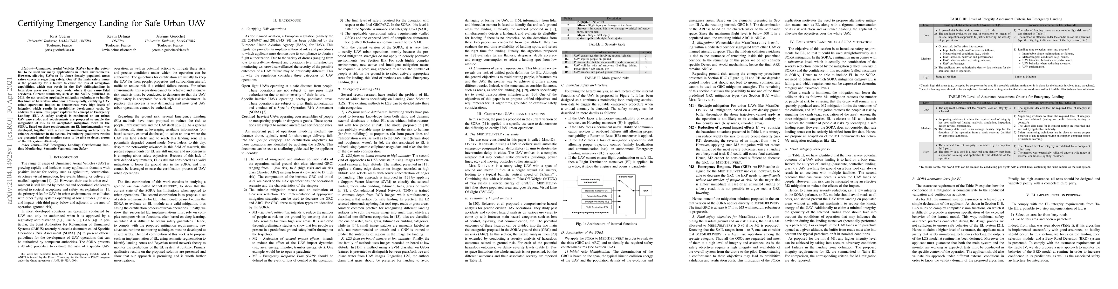
Unmanned Aerial Vehicles (UAVs) have the potential to be used for many applications in urban environments. However, allowing UAVs to fly above densely populated areas raises concerns regarding safety. One of the main safety issues is the possibility for a failure to cause the loss of navigation capabilities, which can result in the UAV falling/landing in hazardous areas such as busy roads, where it can cause fatal accidents. Current standards, such as the SORA published in 2019, do not consider applicable mitigation techniques to handle this kind of hazardous situations. Consequently, certifying UAV urban operations implies to demonstrate very high levels of integrity, which results in prohibitive development costs. To address this issue, this paper explores the concept of Emergency Landing (EL). A safety analysis is conducted on an urban UAV case study, and requirements are proposed to enable the integration of EL as an acceptable mitigation mean in the SORA. Based on these requirements, an EL implementation was developed, together with a runtime monitoring architecture to enhance confidence in the system. Preliminary qualitative results are presented and the monitor seem to be able to detect errors of the EL system effectively.
Key Findings, in focus
Seven facets of this paper, analysed and brought into focus by AI.
This research is important as it addresses the challenge of certifying UAV operations in densely populated areas due to the lack of acceptable mitigation means in current standards like SORA.
- The paper defines safety requirements for EL to be used as a SORA mitigation, categorizing EL under M1 mitigation for reducing the number of people at risk.
- An implementation proposal for EL is presented, including a Busy Road Detection (BRD) system and a safety architecture for monitoring machine learning components at runtime.
- Preliminary results demonstrate the monitor's capability to discard large road areas unseen by the model.
This research is important as it addresses the challenge of certifying UAV operations in densely populated areas due to the lack of acceptable mitigation means in current standards like SORA. EL is proposed as a promising research direction to solve this problem.
The paper proposes safety requirements for EL as a SORA mitigation, adapting M1 requirements for active-M1 techniques like EL, and presents an implementation proposal with a runtime monitoring architecture for machine learning components.
This work is novel in defining a set of requirements for EL consistent with SORA, proposing an implementation of landing zone selection based on semantic segmentation, and introducing a safety architecture for monitoring machine learning components at runtime to comply with the proposed requirements.
- The current approach might not cover all regions containing roads, necessitating investigation into other segmentation models, including lightweight ones.
- The embedded computing power for medium-sized UAVs is often limited, which justifies the selected monitoring architecture that pre-selects candidate landing zones using standard MSDnet and processes only smaller sub-images for verification.
- Complement preliminary results with a formal quantitative study to ensure compliance with identified assurance requirements.
- Investigate other segmentation models, datasets, and uncertainty estimation techniques for improved performance.
- Envision hybrid methods combining learning-based techniques with public databases to enhance emergency landing capabilities.
Impact
Paper Details
Authors
PDF Preview
Key Terms
Citation Network
Current paper (gray), citations (green), references (blue)
Display is limited for performance on very large graphs.
Discussion 0