Joint BEV perception network with parallel detection and localization heads, lightweight object-level sharing over V2V, and integration into a conventional hierarchical planner
CooperDrive: Enhancing Driving Decisions Through Cooperative Perception
Publication
Metrics
Quick Answers
What methodology did the authors use?
Joint BEV perception network with parallel detection and localization heads, lightweight object-level sharing over V2V, and integration into a conventional hierarchical planner More in Methodology →
What are the key results?
State‑of‑the‑art 3D detection on nuScenes (mAP 56.3%, NDS 64.78) surpassing baselines — Localization error reduced to <0.5 m translation and <1° heading under noisy GNSS, outperforming ICP/NDT More in Key Results →
Why is this work significant?
Demonstrates that minimal, object‑level cooperative perception can transform reactive planning into predictive, safer driving in occlusion‑prone urban scenarios while meeting real‑time communication constraints More in Significance →
What are the main limitations?
Evaluation limited to two LiDAR‑equipped vehicles in controlled scenarios — Communication tested only over V2V links, not in dense multi‑vehicle networks More in Limitations →
Abstract
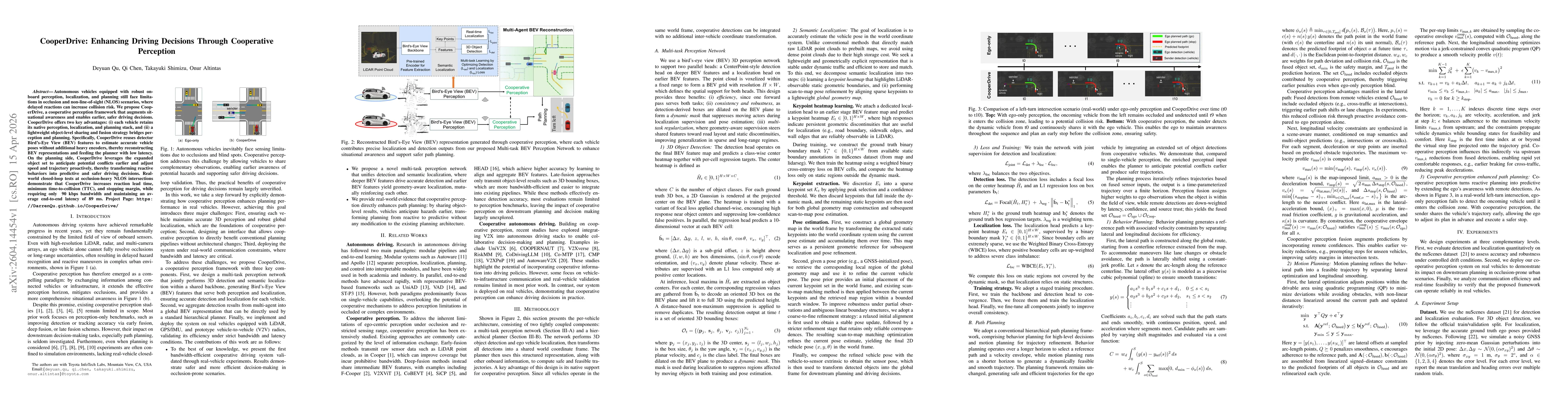
Autonomous vehicles equipped with robust onboard perception, localization, and planning still face limitations in occlusion and non-line-of-sight (NLOS) scenarios, where delayed reactions can increase collision risk. We propose CooperDrive, a cooperative perception framework that augments situational awareness and enables earlier, safer driving decisions. CooperDrive offers two key advantages: (i) each vehicle retains its native perception, localization, and planning stack, and (ii) a lightweight object-level sharing and fusion strategy bridges perception and planning. Specifically, CooperDrive reuses detector Bird's-Eye View (BEV) features to estimate accurate vehicle poses without additional heavy encoders, thereby reconstructing BEV representations and feeding the planner with low latency. On the planning side, CooperDrive leverages the expanded object set to anticipate potential conflicts earlier and adjust speed and trajectory proactively, thereby transforming reactive behaviors into predictive and safer driving decisions. Real-world closed-loop tests at occlusion-heavy NLOS intersections demonstrate that CooperDrive increases reaction lead time, minimum time-to-collision (TTC), and stopping margin, while requiring only 90 kbps bandwidth and maintaining an average end-to-end latency of 89 ms.
Key Findings, in focus
Seven facets of this paper, analysed and brought into focus by AI.
Demonstrates that minimal, object‑level cooperative perception can transform reactive planning into predictive, safer driving in occlusion‑prone urban scenarios while meeting real‑time communication constraints
- State‑of‑the‑art 3D detection on nuScenes (mAP 56.3%, NDS 64.78) surpassing baselines
- Localization error reduced to <0.5 m translation and <1° heading under noisy GNSS, outperforming ICP/NDT
- Planning metrics improved: TTCmin +223 %, DRAC ×0.25, DCZ +2.11 m, VR 18 %→2 %, with 89 ms latency and 90 kbps bandwidth
Demonstrates that minimal, object‑level cooperative perception can transform reactive planning into predictive, safer driving in occlusion‑prone urban scenarios while meeting real‑time communication constraints
A unified BEV multi‑task network that jointly learns detection and geometry‑aware localization, coupled with a lightweight object‑level V2V sharing scheme that preserves low bandwidth and latency for real‑time planning
First to combine BEV feature sharing for detection and localization with minimal object‑level V2V communication, achieving state‑of‑the‑art perception and planning performance in real‑world closed‑loop tests
- Evaluation limited to two LiDAR‑equipped vehicles in controlled scenarios
- Communication tested only over V2V links, not in dense multi‑vehicle networks
- Extend to multi‑vehicle fleets and heterogeneous sensor modalities
- Investigate adaptive communication protocols and learning‑based fusion for larger‑scale deployments
Discussion 0