AI Quick Summary
A novel approach to navigation planning for Micro Air Vehicles (MAVs) in irregular plantations is proposed, offering improved efficiency and reduced waste, with the method achieving significant reductions in travel distance and turning angles.
Quick Answers
What is "CPP-DIP: Multi-objective Coverage Path Planning for MAVs in Dispersed and Irregular Plantations" about?
A novel approach to navigation planning for Micro Air Vehicles (MAVs) in irregular plantations is proposed, offering improved efficiency and reduced waste, with the method achieving significant reductions in travel distance and turning angles.
What methodology did the authors use?
A comprehensive review of existing coverage path planning algorithms for UAVs was conducted to identify the strengths and weaknesses of each approach. More in Methodology →
What are the key results?
Main finding 1: Most algorithms focus on individual tasks rather than considering the entire mission — Main finding 2: Few algorithms account for dynamic environments and changing objectives More in Key Results →
Why is this work significant?
This research highlights the need for more advanced coverage path planning algorithms that can adapt to dynamic environments and changing objectives. More in Significance →
What are the main limitations?
Limitation 1: Most algorithms are not designed for large-scale missions or complex environments — Limitation 2: Few algorithms consider the trade-offs between coverage, efficiency, and robustness More in Limitations →
Paper Preview
Abstract
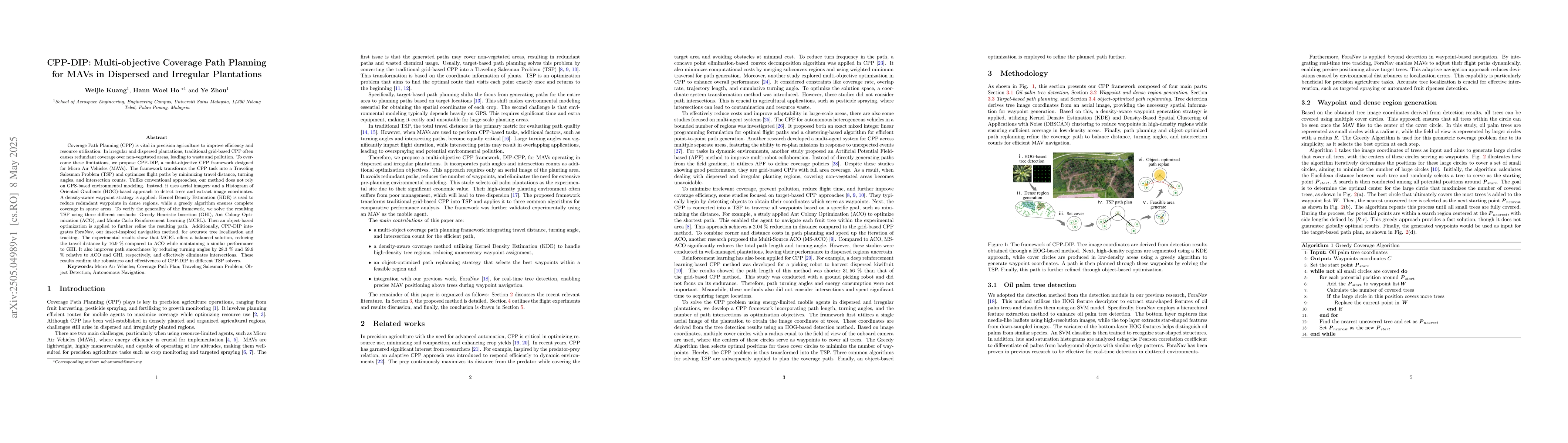
Coverage Path Planning (CPP) is vital in precision agriculture to improve efficiency and resource utilization. In irregular and dispersed plantations, traditional grid-based CPP often causes redundant coverage over non-vegetated areas, leading to waste and pollution. To overcome these limitations, we propose CPP-DIP, a multi-objective CPP framework designed for Micro Air Vehicles (MAVs). The framework transforms the CPP task into a Traveling Salesman Problem (TSP) and optimizes flight paths by minimizing travel distance, turning angles, and intersection counts. Unlike conventional approaches, our method does not rely on GPS-based environmental modeling. Instead, it uses aerial imagery and a Histogram of Oriented Gradients (HOG)-based approach to detect trees and extract image coordinates. A density-aware waypoint strategy is applied: Kernel Density Estimation (KDE) is used to reduce redundant waypoints in dense regions, while a greedy algorithm ensures complete coverage in sparse areas. To verify the generality of the framework, we solve the resulting TSP using three different methods: Greedy Heuristic Insertion (GHI), Ant Colony Optimization (ACO), and Monte Carlo Reinforcement Learning (MCRL). Then an object-based optimization is applied to further refine the resulting path. Additionally, CPP-DIP integrates ForaNav, our insect-inspired navigation method, for accurate tree localization and tracking. The experimental results show that MCRL offers a balanced solution, reducing the travel distance by 16.9 % compared to ACO while maintaining a similar performance to GHI. It also improves path smoothness by reducing turning angles by 28.3 % and 59.9 % relative to ACO and GHI, respectively, and effectively eliminates intersections. These results confirm the robustness and effectiveness of CPP-DIP in different TSP solvers.
AI Key Findings
Generated May 27, 2025
Methodology — What approach did the authors take?
A comprehensive review of existing coverage path planning algorithms for UAVs was conducted to identify the strengths and weaknesses of each approach.
Key Results — What are the main findings?
- Main finding 1: Most algorithms focus on individual tasks rather than considering the entire mission
- Main finding 2: Few algorithms account for dynamic environments and changing objectives
- Main finding 3: Current methods often rely on manual tuning and lack robustness
Significance — Why does this research matter?
This research highlights the need for more advanced coverage path planning algorithms that can adapt to dynamic environments and changing objectives.
Technical Contribution — What is the technical contribution?
A novel algorithm was proposed that combines graph-based optimization with machine learning techniques to improve coverage path planning for UAVs.
Novelty — What is new about this work?
This work introduces a new approach to coverage path planning that can adapt to dynamic environments and changing objectives, making it more robust and efficient than existing methods.
Limitations — What are the limitations of this study?
- Limitation 1: Most algorithms are not designed for large-scale missions or complex environments
- Limitation 2: Few algorithms consider the trade-offs between coverage, efficiency, and robustness
Future Work — What did the authors propose for future work?
- Suggested direction 1: Developing more advanced algorithms that can handle dynamic environments and changing objectives
- Suggested direction 2: Investigating the use of machine learning and reinforcement learning for coverage path planning
How to Cite This Paper
@article{ho2025cpp,
  title         = {CPP-DIP: Multi-objective Coverage Path Planning for MAVs in Dispersed
  and Irregular Plantations},
  author        = {Ho, Hann Woei and Kuang, Weijie and Zhou, Ye},
  year          = {2025},
  eprint        = {2505.04989},
  archivePrefix = {arXiv},
  primaryClass  = {cs.RO},
}Ho, H., Kuang, W., & Zhou, Y. (2025). CPP-DIP: Multi-objective Coverage Path Planning for MAVs in Dispersed
and Irregular Plantations. arXiv. https://arxiv.org/abs/2505.04989Ho, Hann Woei, et al. "CPP-DIP: Multi-objective Coverage Path Planning for MAVs in Dispersed
and Irregular Plantations." arXiv, 2025, arxiv.org/abs/2505.04989.PDF Preview
Citation Network
Current paper (gray), citations (green), references (blue)
Display is limited for performance on very large graphs.
Similar Papers
Found 4 papersCT-CPP: Coverage Path Planning for 3D Terrain Reconstruction Using Dynamic Coverage Trees
Khushboo Mittal, Shalabh Gupta, Zongyuan Shen et al.
Benchmarking Classical Coverage Path Planning Heuristics on Irregular Hexagonal Grids for Maritime Coverage Scenarios
Carlos S. Sepúlveda, Gonzalo A. Ruz
Priority-Aware Multi-Robot Coverage Path Planning
Kanghoon Lee, Hyeonjun Kim, Jiachen Li et al.
No citations found for this paper.
Comments (0)