The research introduces DrivIng, a large-scale multi-modal dataset for autonomous driving, combining camera, LiDAR, and high-precision localization data. It includes three continuous sequences spanning 18km under varied lighting conditions, with detailed annotations and temporal synchronization.
DrivIng: A Large-Scale Multimodal Driving Dataset with Full Digital Twin Integration
Publication
Metrics
Quick Answers
What methodology did the authors use?
The research introduces DrivIng, a large-scale multi-modal dataset for autonomous driving, combining camera, LiDAR, and high-precision localization data. It includes three continuous sequences spanning 18km under varied lighting conditions, with detailed annotations and temporal synchronization. More in Methodology →
What are the key results?
DrivIng achieves higher mAP and NDS scores compared to existing datasets like nuScenes — LiDAR-only models outperform camera-only models in night conditions More in Key Results →
Why is this work significant?
This dataset advances autonomous driving research by providing comprehensive perception data and a digital twin for simulation, enabling better real-world scenario testing and algorithm development. More in Significance →
What are the main limitations?
Limited to specific geographic and environmental conditions — Requires high computational resources for processing More in Limitations →
Abstract
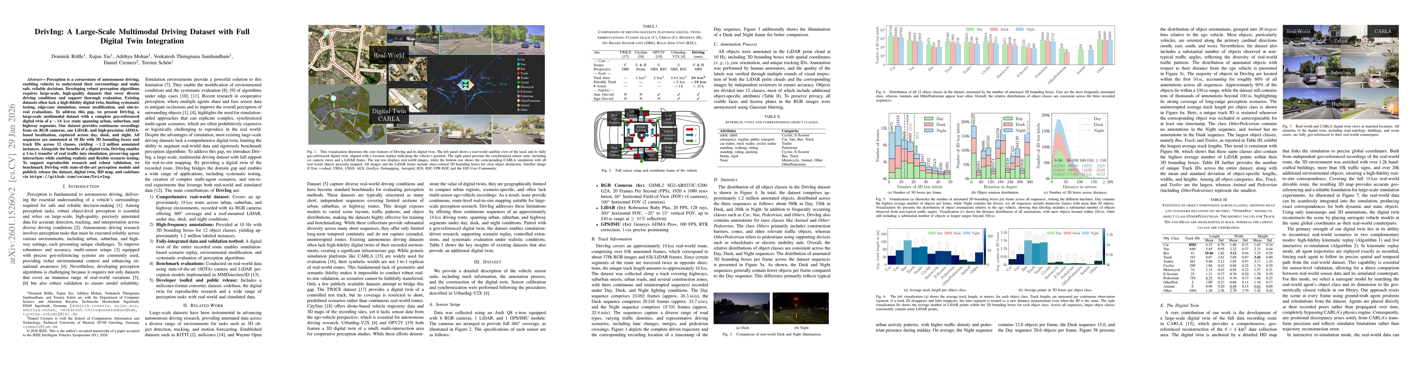
Perception is a cornerstone of autonomous driving, enabling vehicles to understand their surroundings and make safe, reliable decisions. Developing robust perception algorithms requires large-scale, high-quality datasets that cover diverse driving conditions and support thorough evaluation. Existing datasets often lack a high-fidelity digital twin, limiting systematic testing, edge-case simulation, sensor modification, and sim-to-real evaluations. To address this gap, we present DrivIng, a large-scale multimodal dataset with a complete geo-referenced digital twin of a ~18 km route spanning urban, suburban, and highway segments. Our dataset provides continuous recordings from six RGB cameras, one LiDAR, and high-precision ADMA-based localization, captured across day, dusk, and night. All sequences are annotated at 10 Hz with 3D bounding boxes and track IDs across 12 classes, yielding ~1.2 million annotated instances. Alongside the benefits of a digital twin, DrivIng enables a 1-to-1 transfer of real traffic into simulation, preserving agent interactions while enabling realistic and flexible scenario testing. To support reproducible research and robust validation, we benchmark DrivIng with state-of-the-art perception models and publicly release the dataset, digital twin, HD map, and codebase.
Key Findings, in focus
Seven facets of this paper, analysed and brought into focus by AI.
This dataset advances autonomous driving research by providing comprehensive perception data and a digital twin for simulation, enabling better real-world scenario testing and algorithm development.
- DrivIng achieves higher mAP and NDS scores compared to existing datasets like nuScenes
- LiDAR-only models outperform camera-only models in night conditions
- CenterPoint shows better performance on small objects like pedestrians and bicycles
This dataset advances autonomous driving research by providing comprehensive perception data and a digital twin for simulation, enabling better real-world scenario testing and algorithm development.
Development of a high-fidelity, geo-referenced digital twin and comprehensive dataset with 6 RGB cameras, LiDAR, and precise localization
Combines multi-modal sensor data with detailed temporal synchronization and provides benchmark results for state-of-the-art 3D object detectors
- Limited to specific geographic and environmental conditions
- Requires high computational resources for processing
- Expanding to more diverse environments
- Integrating with simulation-to-reality transfer frameworks
Discussion 0